
 Feeds & Data
Magnitude 6.4 - PHILIPPINE ISLANDS REGION
2007 August 20 13:46:17 UTC
Earthquake Details
| Magnitude | 6.4 |
|---|---|
| Date-Time |
|
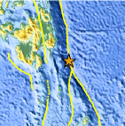
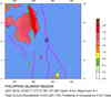
| Location | 6.166°N, 127.426°E |
| Depth | 8 km (5.0 miles) set by location program |
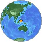
| Region | PHILIPPINE ISLANDS REGION |
| Distances | 220 km (135 miles) ESE of Davao, Mindanao, Philippines 245 km (150 miles) E of General Santos, Mindanao, Philippines 270 km (170 miles) SSE of Hinatuan, Mindanao, Philippines 1170 km (730 miles) SE of MANILA, Philippines |
| Location Uncertainty | horizontal +/- 4.9 km (3.0 miles); depth fixed by location program |
| Parameters | NST=266, Nph=266, Dmin=227.1 km, Rmss=0.99 sec, Gp= 22°, M-type=moment magnitude (Mw), Version=T |
| Source |
|
| Event ID | us2007ggaz |
- This event has been reviewed by a seismologist.
- Did you feel it? Report shaking and damage at your location. You can also view a map displaying accumulated data from your report and others.
Earthquake Summary
The following is a release by the United States Geological Survey, National Earthquake Information Center: An earthquake occurred about 225 km (140 miles) ESE of Davao, Mindanao, Philippines at 7:46 AM MDT, Aug 20, 2007 (9:46 PM local time in Philippines). The magnitude and location may be revised when additional data and further analysis results are available. There have been no reports of damage.
Felt Reports
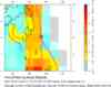
Felt (IV) in Kepulauan Sangihe and (III) in Kepulauan Talaud, Indonesia. Felt (III) at Davao, Mindanao.
 Tsunami Information
- West Coast & Alaska Tsunami Warning Center
- Pacific Tsunami Warning Center
- NOAA Tsunami Warning Center
- Recent Tsunamis
- Tsunami Information Links
The earthquake locations and magnitudes cited in these bulletins are very preliminary, and may disagree with the more accurate USGS locations and magnitudes computed using more extensive data sets.
Earthquake Maps


Scientific & Technical Information

- Preliminary Earthquake Report
- U.S. Geological Survey, National Earthquake Information Center:
World Data Center for Seismology, Denver
