
 Feeds & Data
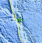
Magnitude 7.2 - VANUATU
2007 August 01 17:08:51 UTC
Earthquake Details
| Magnitude | 7.2 |
|---|---|
| Date-Time |
|
| Location | 15.736°S, 167.745°E |
| Depth | 120 km (74.6 miles) set by location program |
| Region | VANUATU |
| Distances | 70 km (45 miles) ESE of Luganville, Espiritu Santo, Vanuatu 230 km (145 miles) NNW of PORT-VILA, Efate, Vanuatu 450 km (280 miles) NNW of Isangel, Tanna, Vanuatu 1995 km (1240 miles) NE of BRISBANE, Queensland, Australia |
| Location Uncertainty | horizontal +/- 7.7 km (4.8 miles); depth fixed by location program |
| Parameters | NST=246, Nph=246, Dmin=>999 km, Rmss=1.21 sec, Gp= 25°, M-type=moment magnitude (Mw), Version=T |
| Source |
|
| Event ID | us2007fmba |
- This event has been reviewed by a seismologist.
- Did you feel it? Report shaking and damage at your location. You can also view a map displaying accumulated data from your report and others.
Earthquake Summary

The following is a release by the United States Geological Survey, National Earthquake Information Center: An earthquake occurred about 45 km (30 mi) east-southeast of Luganville, Espiritu Santo, Vanuatu at 11:08 AM MDT, Aug 1, 2007 (Aug 02 at 4:08 AM local time in Vanuatu). The magnitude and location may be revised when additional data and further analysis results are available.
Tectonic Summary
This intermediate-depth earthquake occurred within the lithosphere of the Australia plate, which is subducting to the east-northeast beneath the New Hebrides arc and the North Fiji Basin. The lithosphere of the New Hebrides arc and North Fiji Basin consists of zones of deformation and small tectonic plates that accommodate the convergence of the much larger Australia and Pacific plates. The Australia plate moves east-northeast with respect to the interior of the North Fiji Basin with a velocity of about 100 mm/y. The subducted Australia plate is seismically active to a depth of about 300 km in the region of the August 1, 2007 earthquake.
Earthquakes, such as this one, that have focal-depths between 70 and 300 km are commonly termed “intermediate-depth” earthquakes. Intermediate-depth earthquakes represent deformation within subducted plates, rather than deformation at plate boundaries. Intermediate-depth earthquakes typically cause less damage on the ground surface above their foci than is the case with similar magnitude shallow-focus earthquakes, but large intermediate-depth earthquakes may be felt at great distance from their epicenters.
 Tsunami Information
- West Coast & Alaska Tsunami Warning Center
- Pacific Tsunami Warning Center
- NOAA Tsunami Warning Center
- Recent Tsunamis
- Tsunami Information Links
The earthquake locations and magnitudes cited in these bulletins are very preliminary, and may disagree with the more accurate USGS locations and magnitudes computed using more extensive data sets.
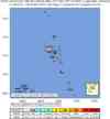
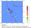
Earthquake Maps


Scientific & Technical Information

- Preliminary Earthquake Report
- U.S. Geological Survey, National Earthquake Information Center:
World Data Center for Seismology, Denver
