
Magnitude 7.1 - TAIWAN REGION
2006 December 26 12:26:21 UTC
Earthquake Details
| Magnitude | 7.1 |
|---|---|
| Date-Time |
= Coordinated Universal Time = local time at epicenter |
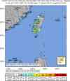
| Location | 21.825°N, 120.538°E |
| Depth | 10 km (6.2 miles) set by location program |
| Region | TAIWAN REGION |
| Distances | 90 km (55 miles) SSE of Kao-hsiung, Taiwan 120 km (75 miles) SSW of T'ai-tung, Taiwan 375 km (235 miles) SSW of T'AI-PEI, Taiwan 800 km (495 miles) N of MANILA, Philippines |
| Location Uncertainty | horizontal +/- 4.8 km (3.0 miles); depth fixed by location program |
| Parameters | Nst=222, Nph=222, Dmin=282.4 km, Rmss=0.93 sec, Gp= 32°, M-type=teleseismic moment magnitude (Mw), Version=Q |
| Source | USGS NEIC (WDCS-D) |
| Event ID | uswtai |
- This event has been reviewed by a seismologist.
Did you feel it?
Report shaking and damage at your location. You can also view a map displaying accumulated data from your report and others.
Earthquake Summary


The following is a release by the United States Geological Survey, National Earthquake Information Center: A major earthquake occurred 90 km (55 miles) SSE of Kao-hsiung, Taiwan and 795 km (495 miles) N of MANILA, Philippines at 6:26 AM MDT, Dec 26, 2006 (8:26 PM local time in Taiwan). The magnitude and location may be revised when additional data and further analysis results are available. No reports of damage or casualties have been received at this time; however, this earthquake may have caused damage due to its location and size.
Felt Reports
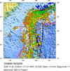
At least one person was killed and three injured at P'ing-tung. Several buildings damaged or destroyed. Felt throughout Taiwan. Also felt along the coast of southeastern China from Shantou in the south to Fuzho in the north.
Tectonic Summary
The southwestern Taiwan earthquakes of 2006 December 26, 12:26 UTC (M = 7.1) and 12:34 UTC (M = 6.9) occurred in a zone of transition along the north-south boundary between the Eurasian plate and the Philippine Sea plate. The Eurasian plate is moving east-southeast with respect to the Philippine Sea plate at a velocity of about 80 mm/y. Along the plate-boundary south of Taiwan, the Eurasian plate is oceanic lithosphere, and convergence is mostly accommodated by the subduction of the Eurasian plate beneath the Philippine Sea Plate. The subducted Eurasian plate is seismically active to depths of about 200 km offshore of southeastern Taiwan, to the east-southeast of the December 26 shocks. North along the plate boundary from southwestern Taiwan to northern Taiwan, by contrast, the Eurasian plate is buoyant continental lithosphere that resists subduction, and a significant fraction of plate convergence is accommodated by intense compressional deformation of the earth’s crust rather than by subduction of one plate beneath the other.
Preliminary focal-mechanism solutions indicate that the earthquake of 12:26 UTC occurred as the result of normal faulting and that the earthquake of 12:34 UTC occurred as the result of predominantly strike-slip faulting.
The normal-faulting focal-mechanism of the shock of 12:26 UTC suggests that this shock occurred as the result of intraplate stresses within the subducting Eurasian plate. Normal-faulting focal-mechanisms are commonly observed in the shallow parts of subducting plates; the causative stresses are generated by the bending of the subducting plates. A normal-fault focal-mechanism is not consistent with the earthquake having occurred as the result of shallow compressional deformation between two converging plates which each consist of buoyant lithosphere.
Presently available evidence does not permit a confident statement on the whether the earthquake of 12:34 UTC occurred as the result of shallow deformation caused by convergence between two plates consisting of buoyant lithosphere or instead occurred as the result of deeper deformation within a subducted and deformed Eurasian plate. The style of faulting preliminarily inferred for the shock of 12:34 UTC, right-lateral strike-slip faulting on a northeast striking fault or left-lateral faulting on a north-northwest striking fault, would be consistent with the style of faulting that has been observed at the surface in southwestern Taiwan and that helps accommodate the mutual convergence of buoyant Eurasian lithosphere and Philippine Sea lithosphere. It is possible, however, that this style of faulting could also occur as the result of intraplate stresses within the subducting Eurasian plate, beneath its boundary with the Philippine Sea plate.


 Historic Moment Tensor Solutions
- Preliminary Earthquake Report
- U.S. Geological Survey, National Earthquake Information Center
World Data Center for Seismology, Denver
