
Magnitude 7.6 - KORYAKIA, RUSSIA
2006 April 20 23:25:02 UTC
Earthquake Details
| Magnitude | 7.6 |
|---|---|
| Date-Time |
= Coordinated Universal Time = local time at epicenter |
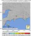
| Location | 61.075°N, 167.085°E |
| Depth | 22 km (13.7 miles) set by location program |
| Region | KORYAKIA, RUSSIA |
| Distances | 195 km (120 miles) NE of Il'pyrskiy, Russia 645 km (400 miles) N of Nikol'skoye, Komandorskiye Ostrova, Rus. 675 km (420 miles) SW of Anadyr', Russia 6330 km (3940 miles) NNE of MOSCOW, Russia |
| Location Uncertainty | horizontal +/- 4.3 km (2.7 miles); depth fixed by location program |
| Parameters | Nst=225, Nph=225, Dmin=778.3 km, Rmss=0.93 sec, Gp= 22°, M-type=teleseismic moment magnitude (Mw), Version=7 |
| Source | USGS NEIC (WDCS-D) |
| Event ID | usltbt |
- This event has been reviewed by a seismologist.
Did you feel it?
Report shaking and damage at your location. You can also view a map displaying accumulated data from your report and others.
Earthquake Summary


Felt Reports
About 40 people injured and the villages of Apuka, Khailino and Vyvenka were destroyed. Some buildings and water supply systems badly damaged in the Korf-Tilichiki area. Damage estimated at 55 million U.S. dollars.
Tectonic Summary
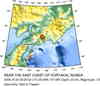
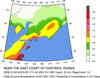
The Koryakia earthquake occurred in sparsely populated northeastern Russia, directly north-northeast of the Kamchatka Peninsula. The earthquake was in a complicated geological setting where the configuration and interaction of the tectonic plates between northeastern Asia and northwestern North America are poorly understood. Recent models of the tectonic plates in eastern Russia show that the earthquake occurred near the junction of two plates. These are (1) the Okhotsk plate, which includes the Sea of Okhotsk, the Kamchatka Peninsula and northern Japan, and (2) the extreme northwestern margin of the North American plate. Some evidence indicates that a third plate, the Bering plate, may be present and play a role in the regional tectonics, but this plate is poorly defined with uncertain boundaries.
Geologically, northeastern Russia in the vicinity of the Koryakia earthquake is composed of a sequence of volcanic island arcs that have been attached or accreted to the margin of a continent. In addition, between about 160 and 65 million years ago, sedimentary basins formed in the region and magma intruded the crust and erupted onto it as volcanoes. The boundaries between accreted island arcs are commonly large faults which, under suitable conditions, might be reactivated to cause earthquakes. So many of these old faults formed during the accretion process that it might be difficult to determine which, if any of them broke to cause the Koryakia earthquake.
Current models of plate interactions in northeastern Russia indicate that the region is being squeezed in a southeast-northwest direction, which causes shortening at a rate that might be only a few millimeters per year. This southeast-northwest direction of long-term shortening is consistent with the focal mechanism of the Koryakia earthquake, which shows that shortening produced thrust movement on faults that are oriented in a northeast-southwest direction.
Earthquake Information for Asia
 Tsunami Information
- West Coast & Alaska Tsunami Warning Center
- Pacific Tsunami Warning Center
- Recent Tsunamis
- Tsunami Information Links
The earthquake locations and magnitudes cited in these bulletins are very preliminary, and may disagree with the more accurate USGS locations and magnitudes computed using more extensive data sets.


 Historic Moment Tensor Solutions
- Preliminary Earthquake Report
- U.S. Geological Survey, National Earthquake Information Center
World Data Center for Seismology, Denver
