
Magnitude 6.6 - NEW BRITAIN REGION, PAPUA NEW GUINEA - usgmat
2005 December 11 14:20:43 UTC
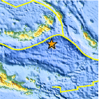
A strong earthquake occurred at 14:20:43 (UTC) on Sunday, December 11, 2005. The magnitude 6.6 event has been located in the NEW BRITAIN REGION, PAPUA NEW GUINEA. (This event has been reviewed by a seismologist.)
Earthquake Details
| Magnitude | 6.6 |
|---|---|
| Date-Time |
= Coordinated Universal Time = local time at epicenter |
| Location | 6.594°S, 152.208°E |
| Depth | 10 km (6.2 miles) set by location program |
| Region | NEW BRITAIN REGION, PAPUA NEW GUINEA |
| Distances | 250 km (155 miles) SSW of Taron, New Ireland, PNG 255 km (155 miles) ESE of Kimbe, New Britain, PNG 635 km (395 miles) ENE of PORT MORESBY, Papua New Guinea 2310 km (1440 miles) N of BRISBANE, Queensland, Australia |
| Location Uncertainty | horizontal +/- 3.6 km (2.2 miles); depth fixed by location program |
| Parameters | Nst=272, Nph=272, Dmin=637.1 km, Rmss=0.76 sec, Gp= 32°, M-type=teleseismic moment magnitude (Mw), Version=S |
| Source | USGS NEIC (WDCS-D) |
| Event ID | usgmat |


- Preliminary Earthquake Report
- U.S. Geological Survey, National Earthquake Information Center
World Data Center for Seismology, Denver
