
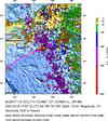
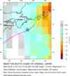
Magnitude 7.4 - NEAR THE SOUTH COAST OF HONSHU, JAPAN
2004 September 5 14:57:18 UTC
Earthquake Details
| Magnitude | 7.4 |
|---|---|
| Date-Time |
= Coordinated Universal Time = local time at epicenter |
| Location | 33.184°N, 137.071°E |
| Depth | 10 km (6.2 miles) set by location program |
| Region | NEAR THE SOUTH COAST OF HONSHU, JAPAN |
| Distances |
170 km (105 miles) SSE of Tsu, Honshu, Japan 175 km (110 miles) SSW of Hamamatsu, Honshu, Japan 205 km (130 miles) ESE of Wakayama, Honshu, Japan 365 km (230 miles) SW of TOKYO, Japan |
| Location Uncertainty | horizontal +/- 3.3 km; depth fixed by location program |
| Parameters | Nst=477, Nph=477, Dmin=385.6 km, Rmss=0.89 sec, Gp= 27.5°, M-type=teleseismic moment magnitude (Mw) |
| Source | USGS NEIC (WDCS-D) |
| Event ID | usnaav |
- This event has been reviewed by a seismologist.
Did you feel it?
Report shaking and damage at your location. You can also view a map displaying accumulated data from your report and others.


 Historic Moment Tensor Solutions
- Preliminary Earthquake Report
- U.S. Geological Survey, National Earthquake Information Center
World Data Center for Seismology, Denver
