Magnitude 5.1 - OFFSHORE BAJA CALIFORNIA, MEXICO
2004 June 15 22:28:48 UTC


Earthquake Details
| Magnitude | 5.1 (Moderate) |
|---|---|
| Date-Time |
= Coordinated Universal Time = local time at epicenter |
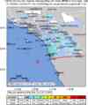
| Location | 32.329°N, 117.918°W |
| Depth | 10 km (6.2 miles) (poorly constrained) |
| Region | OFFSHORE BAJA CALIFORNIA, MEXICO |
| Distances | |
| Location Uncertainty | horizontal +/- 4.8 km (3.0 miles); depth +/- 31.6 km (19.6 miles) |
| Parameters | Nph=027, Dmin=169 km, Rmss=0.4 sec, Gp= 68°, M-type=local magnitude (ML), Version=P |
| Source | |
| Event ID | ci14065544 |
- This event has been reviewed by a seismologist.
Did you feel it?
Report shaking and damage at your location. You can also view a map displaying accumulated data from your report and others.