|
|
|
Metadata
|
|
ID
|
07042
|
|
Also Known As
|
R-6-07-MA
07042
|
|
Abstract
|
United States Geological Survey, Woods Hole, Massachusetts.
Chief Scientist: Rich Signell. Data (Navigation-GPS, SEABOSS)
of field activity 07042 (R-6-07-MA) in Middle Ground,
Vineyard Sound, Massachusetts, United States, North America,
North Atlantic from 11/20/2007 to 11/20/2007
|
|
Organization
|
United States Geological Survey, Woods Hole, Massachusetts
|
|
Project/Theme
|
Middle Ground
|
|
Chief Scientist
|
Rich Signell
|
|
Platform
|
Rafael
|
|
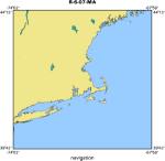
Area of Operation
|
Middle Ground, Vineyard Sound, Massachusetts, United States, North America, North Atlantic
|
|
Location map
|
|
|
Bounding Coordinates
|
41.52000
-70.85000 -70.45000
41.36000
|
|
Ports
|
LEAVE Woods Hole
ARRIVE Woods Hole
|
|
Dates
|
11/20/2007 (JD 324) to 11/20/2007 (JD 324)
|
|
Analog Materials
|
No analog holdings.
|
|
Index map

|
|
|
Information Specialist
|
|
|
Crew
|
|
Rich Signell
|
Chief Scientist
|
|
Dann Blackwood
|
|
|
Chuck Worley
|
Skipper
|
|
|
Equipment Used
|
|
|
Purpose
|
|
To obtain sediment grab samples and bathymetric depths from
|
|
Middle Ground.
|
|
|
Information to be Derived
|
|
Grain size analysis;Sea Floor Map;Bathymetric Maps;
|
|
|
Summary
|
|
~1.5 hours of video in 13 segments (2 DVDs & one 8 mm tape)
|
|
9 sediment grab samples bathymetric depths from depth sounder and
|
|
lon,lat from differential GPS along ship track.
|
|
|
Notes
|
|
|
Got Help?
|
For 07042, we would appreciate any information on -- activity type, analog materials, contract, days at sea, dive count, funding, kms of navigation, national plan, NGDC Info, owner, project number, publications, scanned materials, seismic description, station count, station description, submersible, tabulated info.
|
|