|
|
|
Metadata
|
|
ID
|
B-PC-71-AK
|
|
Also Known As
|
71GSG
|
|
Abstract
|
British Petroleum. Geophysical data of field activity
B-PC-71-AK in NE NPR-A, Colville Delta, Prudhoe Bay from
00/00/1971 to 00/00/1971
|
|
Organization
|
British Petroleum
|
|
Activity Type
|
Geophysical
|
|
Area of Operation
|
NE NPR-A, Colville Delta, Prudhoe Bay
|
|
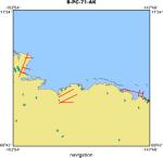
Location map
|
|
|
Bounding Coordinates
|
70.88087
-152.67283 -148.05536
70.25657
|
|
Dates
|
00/00/1971 (JD 000) to 00/00/1971 (JD 000)
|
|
Analog Materials
|
No analog holdings.
|
|
Scanned Materials
|
B-pc-71-ak.71gsg_si15372 log (pdf)
B-pc-71-ak.pre-75_2d_surveys log (pdf)
|
|
Index map

|
|
|
Information Specialist
|
|
|
Notes
|
|
Line names: G-81 to G-90
|
|
|
Source of processes data loaded to, and copied from Landmark:
|
|
|
SeisScan Geodata SEG-Y data for G-81, 82, 83, 84, 85, 86, 87, 88, 89, 90
|
|
|
Tape data available:
|
|
processed data tapes for G-81, 82, 83, 84, 85, 90
|
|
field data tapes for G-81, 82, 83, 84, 85, 86, 88, 89, 90
|
|
|
reproducible media available:
|
|
mylar films for G-81, 82, 83, 84, 85, 86, 87, 88, 89, 90
|
|
|
cartography file available: 71gsg.utm6
|
|
|
Got Help?
|
For B-PC-71-AK, we would appreciate any information on -- analog materials, chief scientist, contract, crew, days at sea, dive count, equipment used, funding, information to be derived, kms of navigation, national plan, NGDC Info, owner, platform, ports, project, project number, publications, purpose, scanned materials, seismic description, station count, station description, submersible, summary, tabulated info.
|
|


