
1998 USGS Expedition to Mongolia
Mongolia, a country of 2.5 million people living within an area four times the size of California, is a spectacular natural laboratory for studying faults and great earthquakes that occur in the interior of continents far from plate boundaries. During the 20th century, western Mongolia experienced three earthquakes of approximately M8, and another six events of about M7. Figure 1 gives the locations of these events.
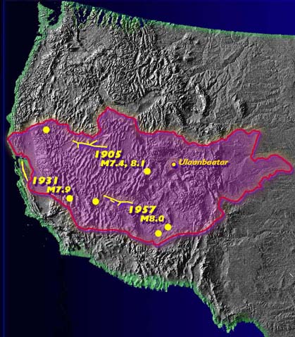
Figure 1. Outline of Mongolia superimposed on a shaded relief map of the western United States. The yellow lines on the figure show the portions of the faults that ruptured the ground surface during the three M8+ events that occurred during the 20th century. Six M7+ earthquakes also occurred during the 20th century in Mongolia and produced surface faulting as well, but are only represented as dots on this map.
The three great earthquakes were the 1905 Bulnay earthquake in northwest Mongolia, the 1931 Fu Yun earthquake (actually just across the border in China), and the 1957 Gobi-Altay event in the northern Gobi desert. The 20th century earthquake activity in Mongolia represents a larger amount of seismic energy release than has occurred in California during a comparable period. This is intriguing because the rates of crustal movements in Mongolia, which is in the interior of the Asian plate some 2600 km (~1600 miles) from the India-Asia collision boundary, are only about 1/10th the rates measured along the Pacific-North American plate boundary, which passes directly through California. This regional earthquake clustering of seismic energy release appears to be a common process in plate interiors, but the cause of it is not well understood.
Our Mongolia work suggests that large magnitude earthquakes in continental interiors reflect stress accumulation across a large volume of crust (200-300 km long by 30-50 km across) that is released and partitioned onto a complex sequence of strike-slip and thrust faults. The low fault slip rates and small amount of long term fault offset may account for the complex faulting pattern. We believe that the rupture complexity of the 1905 Bulnay earthquake sequence and the 1957 Gobi-Altay earthquake bears strong resemblance to that of the great 1811-1812 New Madrid earthquakes in the central United States. This comparison is shown in Figure 2.
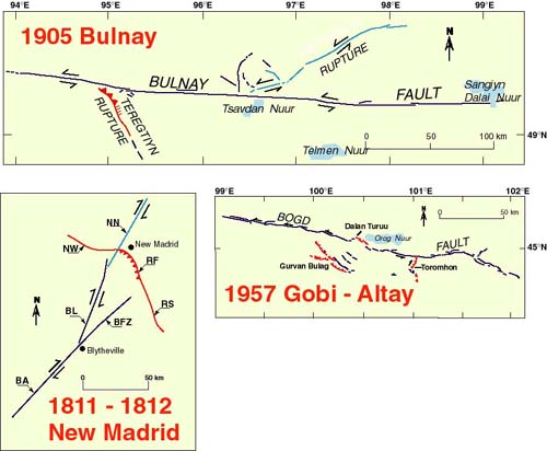
Figure 2. Maps of surface rupture from the 1905 Bulnay and 1957 Gobi-Altay earthquakes in Mongolia, and a rupture model for the 1811-1812 New Madrid earthquakes in the central U.S. Map scale is the same for all three figures. Strike-slip faulting is shown in blue and thrust faulting in red. The geologic setting and the scale and overall complexity of the various earthquake ruptures are strikingly similar.
The New Madrid seismic zone is an area of active research at the USGS, but unfortunately, the zone is largely under the Mississippi River and therefore the details of its rupture pattern and history cannot be studied directly. On the other hand, the arid, cold climate of Mongolia preserves fine features of surface fault rupture for long periods after an earthquake. Because the great Mongolian earthquakes are similar to New Madrid in terms of geologic setting and rupture complexity, the information that we can obtain on active faulting in Mongolia can be directly applied to improving our understanding of the earthquake framework in the central United States, and the seismic hazard associated with faults such as the New Madrid seismic zone.
