|
National Defense University
Fort Lesley J. McNair, Washington D.C.
Welcome to the National Defense
University. The University is located on the grounds of Fort
Lesley J. McNair in Southwest Washington, D.C., between the Anacostia
River and the Washington Channel.
Travel Directions:
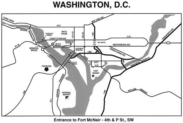
Via METRO: NDU is located about one mile from the Washington Metro’s Waterfront station on the Green Line. Leaving the station, cross Maine Avenue and walk down 4th Street (S) for three blocks until it ends and, turning left, becomes P Street SW. The Fort McNair main gate will be plainly visible. The P Street gate, located beyond the main gate about two blocks, is to be used by all visitors driving. Pedestrians can access Fort McNair through the main gate with proper ID.
- From Arlington and points South and West (via 14th St Bridge): Follow I-395 North across the Potomac River to the Maine Avenue exit on the right. Follow the exit straight ahead (through the stop sign) and turn left (E) on Maine Avenue at the traffic light. Follow Maine Avenue until it curves left and becomes M Street SW. Turn right (S) on 4th Street SW and continue two blocks until it ends and becomes P Street SW. Immediately after turning left on P Street, the Fort McNair main gate will be plainly visible on the right. Visitors must enter Fort McNair through the second gate, two blocks down from the main gate and on the right (at 2d Street).
- From Alexandria or Anacostia (via Woodrow Wilson Bridge): Follow I-295 North to the South Capitol Street exit. Proceed across the South Capitol Street Bridge, staying to the right. Bear right coming off the bridge, avoiding the underpass, and turn left on to M Street SW at the traffic light. Continue West on M Street SW to 4th Street SW. Turn left (S) on 4th Street SW and continue two blocks until it ends and becomes P Street SW. Immediately after turning left on P Street, the Fort McNair main gate will be plainly visible on the right. Visitors must enter Fort McNair through the second gate, two blocks down from the main gate on the right (at 2d Street).
- From Maryland, Prince George’s County and Eastern Montgomery County: Follow the Capitol Beltway (I-495 or I-95) to the Baltimore-Washington (B-W) Parkway exit. Proceed Southbound on the B-W Parkway. As you near Washington, the B-W Parkway will become I-295 South. Continue on I-295 to the Suitland Parkway exit. Exit at the Suitland Parkway and then immediately exit on to I-295 Northbound. After joining I-295 North, immediately exit at the South Capitol Street exit. Proceed across the South Capitol Street Bridge, staying to the right. Bear right coming off the bridge, avoiding the underpass, and turn left on to M Street SW at the traffic light. Continue West on M Street SW to 4th Street SW. Turn left (S) on to 4th Street SW and continue two blocks until it ends and becomes P Street SW. Immediately after turning left on P Street, the Ft McNair main gate will be plainly visible on the right. Visitors must enter Fort McNair through the second gate, two blocks down from the main gate and on the right (at 2d Street).
- Hours of Operation: The Main Gate is open 0600-1700 Monday through Friday (closed on Federal Holidays;, the Visitors Gate is open 24 hours; and the Pedestrian Gate near the Coast Guard Headquarters Building is open Monday through Friday, 0600-1800 (closed on Federal Holidays).
- Picture identification is required at all gates.
Fort McNair Map
|

