|
Columbia River and the Columbia Basin, Washington/Oregon, September 1994.
-- NASA Photo, courtesy "NASA Earth From Space" Website; Modified with text by USGS/CVO STS064-112-093 STS064-112-093. Columbia River and Richland, Washington, U.S.A. September 1994. The agricultural and grazing lands of the Columbia Basin in south-central Washington can be seen in this north-looking, low-oblique photograph. Underlying the 100,000 square miles (259 000 square kilometers) of the Columbia Basin are deposits of lava (mainly basalt) interbedded with sedimentary rock nearly 10,000 feet (3050 meters) thick. The dry river canyons and scablands (extensively eroded basalt surfaces) were carved by glacial meltwaters. An important agricultural and grazing area, the basin is also a major source of hydroelectric power. The Columbia River (seen entering at the northwest and exiting at the southwest corners of the photograph) rises in Columbia Lake in southeast British Columbia, Canada, enters the state of Washington, and encounters the Columbia Basin. The river alters its course to the west because of numerous lava beds, turns again to the south, where it is entrenched in a narrow valley through the central plateau region, and joins the Snake River south of Richland near Lake Wallula. -- Excerpt from: NASA Earth From Space Website, 2002 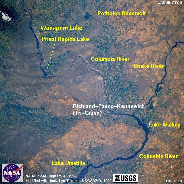
|
Return to:
[CVO Photo Archives - NASA Images Menu] ...
[CVO Photo Archives Menu] ...
[Columbia Plateau Menu] ...
[Columbia River Vicinity Menu] ...
[Washington State Volcanoes and Volcanics Menu] ...
[The Volcanoes of Lewis and Clark] ...