
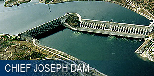
chief joseph dam is located in north central washington state, just upstream
from the town of bridgeport. you will find us where wa highway 17 crosses the
columbia river. we suggest beginning your visit to chief joseph dam at the
orientation area. there you will find interpretive displays and brochures which
will guide you on your journey. below are 3 sets of directions, some suggestions
and 2 maps to help you.
from wenatchee: drive east on us 2 for 13 miles, and then north on us
97 for 57 miles. turn right (east) on wa 17 for 8 miles until you see chief
joseph dam. turn left shortly before the columbia river bridge and begin your
visit at the orientation area.
from spokane: drive west on us 2 for 97 miles until you intersect wa
17 past coulee city. (note wa 17 joins us 2 for 2 miles before turning north.)
follow wa 17 north for 40 miles until you reach bridgeport. continue driving
across the columbia river bridge where you should turn right and begin your
visit at the orientation area.
from penticton, bc: travel south on canadian highway 97, for 35 miles
to the u.s. border. continue south on us 97 through oroville and omak for 76
miles. turn left (east) onto wa 17 for 8 miles. turn left just before the
columbia river bridge to begin your visit at the orientation area.
as you approach the dam, tune your radio to am 1610. our broadcast will
familiarize you with the history of the dam, as well as recreation opportunities
in the area. now that you have gotten to the vicinity of chief joseph dam it is
time to learn the layout. click on the map below. the orientation area display
will show you how to follow the visitor route to reach the visitor center. the
corps of engineer's project office is located are on the south shore of the
columbia river.
