
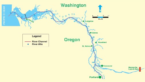
The U.S. Army Corps of Engineers has been connected to the Lower Columbia River (See map below) since the Lewis and Clark expedition of 1805. Soon after, the Corps began the difficult yet essential tasks of surveying and mapping. The development of these maps led to the more concentrated involvement which began in the 1860's, as the Corps was charged with improving navigation in the Columbia and Willamette rivers. While early efforts centered primarily on improving navigation in the river, the Corps eventually worked with local communities to protect them against periodic floods. With additional evolutions of the Corps' mission, the agency has become actively involved in scientific evaluation and environmental restoration in the Columbia River.
The Corps has performed - and continues to perform - important work in the lower river. However, with over 100 years of involvement with large and complicated infrastructure projects, there have been inevitable conflicts with the interests of various stakeholders. The type of projects, combined with legislated policy goals and administrative procedures, can make the Corps' process difficult to understand. The constraints that the Corps operates within often do not allow us to address local or regional concerns. This has, in many cases, resulted in mixed feelings towards the agency. One such issue that has strained relationships at the mouth of the Columbia River is the disposal of dredged materials and how the Corps selects disposal sites. You can read more about the issues affecting the Lower Columbia River on our Issues page.
The purpose of this website is to improve the Corps' relationship with other groups and individuals in the region by informing the public about our activities in the Lower Columbia River: to show what we are doing, where, when, and how, and to provide the science, planning, and policy documents that are the basis of our decisions. While these decisions and the projects we pursue are unlikely to please everyone, it is our goal to clear up misconceptions by making our processes and activities transparent in the hope that individuals and groups will better understand us; and that through this understanding working relationships may be created, repaired, or improved.
Today, the Corps is more involved in the Lower Columbia River than at any other time in its history. Whether it's maintaining the existing infrastructure (jetties, ports, and navigation channels), performing valuable environmental restoration work, or advancing scientific knowledge through numerous scientific evaluation projects, the Corps remains a key partner in the Lower Columbia River. The figure provides a visual representation of the three focus ares for the Corps on the LCR and how they are related.
The Corps does not operate in a vacuum, and has developed many valuable partnerships in the course of its work in the Lower Columbia River. These partners (and stakeholders) are instrumental in helping the Corps work though the planning process for water resources development projects and meet the requirements necessary for funding the work.