USGS - science for a changing world

Texas Water Science Center
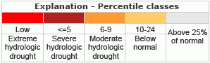
  home information/data projects publications droughtwatch floodwatch cooperators contact

DATA CENTER

USGS IN YOUR STATE

USGS Water Science Centers are located in each state.

There is a USGS Water Science Center office in each State. Washington Oregon California Idaho Nevada Montana Wyoming Utah Colorado Arizona New Mexico North Dakota South Dakota Nebraska Kansas Oklahoma Texas Minnesota Iowa Missouri Arkansas Louisiana Wisconsin Illinois Mississippi Michigan Indiana Ohio Kentucky Tennessee Alabama Pennsylvania West Virginia Georgia Florida Caribbean Alaska Hawaii New York Vermont New Hampshire Maine Massachusetts South Carolina North Carolina Rhode Island Virginia Connecticut New Jersey Maryland-Delaware-D.C.

Texas DroughtWatch

This map below (from USGS's National Drought Watch Web site) shows the 7-day average streamflow conditions in hydrologic units. Thus, the map shows conditions adjusted for this time of the year. The colors represent 7-day average streamflow percentiles for the day of the year. USGS sites having at least 30 years of record are used. The data used to produce this map are provisional and have not been reviewed or edited. They may be subject to significant change.

Quick Links:

Map of below normal 7-day average streamflow compared to historical streamflow for the day of year

Map of below normal 7-day average streamflow compared to historical streamflow for the day of year.

Map legend for below normal 7-day average streamflow condition map


 A postscript (EPS) file of this map is available.

USGS Home Water Resources Biology Geography Geology Geospatial

Accessibility FOIA Privacy Policies and Notices

Take Pride in America logo USA.gov logo U.S. Department of the Interior | U.S. Geological Survey
URL: http://tx.usgs.gov/drought/index.html
Page Contact Information: gs-w-txpublicinfo@usgs.gov
Page Last Modified: Thursday, 26-Jun-2008 08:06:01 EDT