![]() News.bytes Extra, issue 355
News.bytes Extra, issue 355
Modoc Line to add 85 miles of trail to Northeast California
Government and private partners in northeast California celebrated a linkage between the past and future last week, when they gathered along a rugged stretch of the Modoc-Lassen County line to celebrate a new Rail-Trail conversion.
Representatives from Modoc and Lassen counties joined with representatives of BLM-California's Eagle Lake and Alturas field offices, executive directors for the California Wildlife Conservation Board (WCB) and Sierra Nevada Conservancy, and directors from the non-profit Lassen Land and Trails Trust (LLTT) to celebrate transfer of an 85-mile stretch of former railroad into ownership of the Lassen Land and Trails Trust.
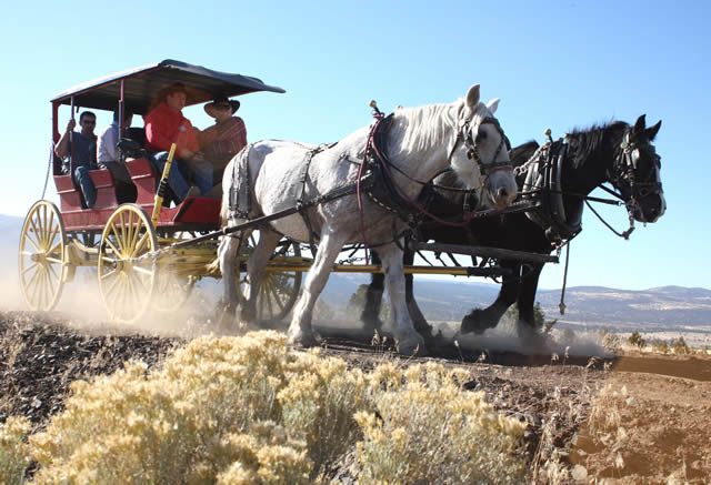
Below, they rode in a 120-year-old stagecoach and a rustic horse-drawn farm wagon along the route of the Wendel to Alturas railroad line. They stopped for a ribbon cutting ceremony marking completion of rail banking negotiations and beginning of a new recreation trail through the high desert. (The stagecoach was loaned by the City of Susanville. Local rancher Bill Waltman provided the horses and farm wagon. BLM horse wranglers Thad Waltman and Pat Cannon drove the teams teams and Victor Gragnani of Spanish Springs Ranch also helped drive one of the teams.)
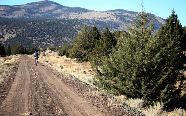
A solitary mountain biker leads the way, third photo.

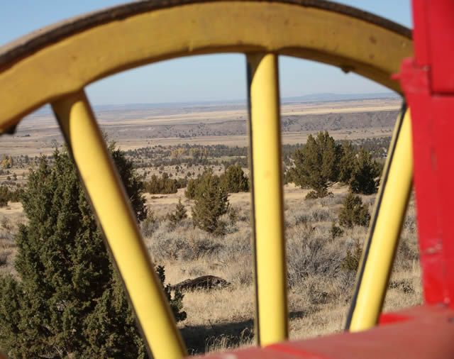
The scenery along the Modoc Line is little changed from its days as a stage route, and later, an important railroad line. Below is a view of the Likely Tablelands from the stagecoach vantage point.
The Modoc Line began in the 1800s as a narrow gauge railroad operated by the Nevada-California-Oregon Railroad. It was later converted to standard gauge, and most recently operated by the Union Pacific Railroad until its abandonment in the 1990s.
Discussions about rail banking the corridor (using the line for a recreational trail while preserving options for resumption of rail service) began in 1997, with the BLM Eagle Lake Field Office initially negotiating transfer of the railroad property. The BLM Alturas Field Office then entered the negotiations along with the Lassen Land and Trails Trust in about 2006.
The railbanking arrangement culminated with the Lassen Land and Trails Trust taking ownership. The Sierra Nevada Conservancy provided a $37,000 grant to LLTT for appraisal and other preliminary costs. The WCB granted LLTT $420,000 for the purchase of the former railroad property from Union Pacific. WCB supported the project because it will help conserve areas with important wildlife values.

Cutting the ceremonial ribbon, above, were from left, John Donnelly, executive director of the Wildlife Conservation Board; David Bradshaw and Pat Cantrall, Modoc County Board of Supervisors; Tim Burke, field manager for the BLM Alturas Field Office; Matt Sayles, executive director, Lassen Land and Trails Trust; Brian Dahle, Lassen County Board of Supervisors; and Jim Branham, executive director, Sierra Nevada Conservancy.
Speakers at the ceremony praised the partnerships that led to the rail banking arrangement. Lassen County Supervisor Dahle envisioned a day when the Modoc Line could provide a recreational trail link between Alturas and Westwood, a 125-mile distance. Such a link would connect the Modoc Line and Bizz Johnson National Recreation Trails -- both Rail Trails. Modoc County Supervisors Bradshaw and Cantrall said the Modoc Line success epitomizes the spirit of partnership prevalent in northeast California.
Lassen Land and Trails Trust will now partner with Modoc and Lassen counties and the BLM to develop a trail master plan. The plan will consider uses, non-motorized and motorized, that would be appropriate. The 85-mile trail route crosses public and private land, with about 50 miles on public land managed by the BLM.
- J. Fontana, 10/27/08
More history, from recreation planner Stan Bales, with BLM-California's Eagle Lake Field Office:
The Modoc Line began in the 1800s as a narrow gauge railroad operated by The Nevada and Oregon Railroad Company with plans to build from Reno north to Lakeview, Oregon and eventually on to the Columbia River. Due to financial struggles the narrow gage railroad company was reorganized, refinanced and and renamed three times. In 1893 the company became the Nevada, California and Oregon Railroad (NC+O), a name that held for 32 years. Locals referred to it as the Narrow, Crooked and Ornery. It took the small struggling railroad 31 years to reach Lakeview, Oregon and that is as far as the NC+O line was ever built. In 1925 the NC+O was purchased by Southern Pacific Railroad and converted to standard gauge in 1927. A connection between Alturas and Klamath Falls, Oregon was completed in 1929 and the line became known as the Modoc Line.
The Modoc Line served as Southern Pacific’s inland route east of the northern Sierra and southern Cascades for the next 71 years. In 1996 the Modoc Line was acquired by Union Pacific Railroad and the 85 miles segment from just north of Wendel to 12 miles south of Alturas, California was scheduled for abandonment. However, under Union Pacific Railroad ownership, the entire Modoc line was briefly operated as a backup line to UPRR’s other main lines when storms closed UPRR’s lines over the Sierra and through California’s Central Valley during the New Years Day flood of 1997. Tracks were finally removed on the 85 mile segment between Wendel and McArthur siding, 12 miles south of Alturas in 2003.
BLM staff at the Eagle Lake Field Office initiated the process to rail bank the 85-mile segment of the Modoc line proposed for abandonment after the abandonment notice was published in 1996. Rail banking is a process for using the line for a recreational trail while preserving options for resumption of rail service. It took 12 years for the rail banking process to be realized. BLM was involved because approximately 42 miles of the proposed abandonment crosses BLM lands and the railroad corridor would make an excellent trail for access to and through public lands. However, BLM did not initiate the rail banking effort without the support of Lassen and Modoc County supervisors, the City of Susanville and the City of Alturas and local trails groups. The BLM Alturas Field Office manager, Tim Burke, was instrumental in helping move the rail banking effort along in the later years of the process. Both Lassen and Modoc Counties were interested in acquiring the line but it ended up that Board of Directors of a local non-profit group, Lassen Land and Trails Trust, had the fortitude to acquire the line when rail banking efforts between UPRR and Lassen and Modoc Counties were derailed by certain language that the railroad insisted on that the counties could not accept. Under the able leadership of Lassen Land and Trails Trust’s Executive Director, Matt Sayles, the Trust completed acquisition negotiations, secured funding and acquired the Modoc Line in September 2008.
BLM-California News.bytes, issue 355