| Subject Areas |
|
Art and Culture
|
| |
Archaeology |
|
History and Social Studies
|
| |
U.S. History - Other |
| |
World History - Ancient World |
| |
World History - Europe |
| |
| Time Required |
| | One to two class periods
|
| |
| Skills |
| | information gathering and research skills
primary source analysis
visual analysis
critical thinking
historical interpretation
Internet research
|
| |
| Date Posted |
| | 4/17/2002 |
| |
| Feedback |
| |
Send us your thoughts about this lesson! |
| |
| Email this Lesson |
| |
Send this lesson to friends or colleagues |
| |
|

|
Mapping the Past
Introduction
This
lesson provides students with experience in working with historical maps as cultural
artifacts that reflect the views of particular times and places. Students begin
by examining European world maps from three eras -- the Middle Ages, the Age of
Discovery, and the period of New World exploration -- in order to discover how
people of those times understood their world and interacted with it. Then students
look at maps that record the early exploration of the American West, noting how
mapmakers kept alive hopes of finding a Northwest Passage and how this hope is
reflected in what Lewis and Clark marked as significant on the map produced by
their expedition. Finally, students collect present-day maps, using library and/or
Internet resources, to investigate the range of perspectives we adopt toward our
world and how our maps reflect our own cultural concerns and aspirations.
Learning Objectives
(1) To examine historical maps as cultural artifacts that
reflect the views of particular times and places; (2) To trace the evolving world
view from medieval times through the Renaissance as recorded in maps of those
eras; (3) To investigate how cultural assumptions influenced the process of mapping
the American West; (4) To discover what present-day maps can tell us about our
world view and cultural aspirations.
1
Begin by providing each student with a copy of the Map
Analysis Worksheet available through EDSITEment at the Digital
Classroom website of the National Archives and Records Administration. At
the website's homepage, click "Document Analysis Worksheets" in the blue sidebar
and click Map.
Discuss with students how they can use the worksheet to discover various kinds
of information in an historical map, including facts about the map itself (date,
creator, purpose, etc.) and facts about the past. Explain that in this lesson
students will use the worksheet to examine a variety of historical maps, first
comparing European world maps from different eras, then tracing the process of
mapping the American West. (Note: Point out to students that some questions on
the "Map Analysis Worksheet" (e.g., 6D and 6E) may not be relevant to this lesson.)
2 Divide
the class into small study groups and have each group use the "Map Analysis Worksheet"
to prepare a class report on the significance of one of the following historical
maps available through EDSITEment:
3 Have
each group display and report on its map, summarizing the findings recorded on
their "Map Analysis Worksheets." As students present their reports, call attention
to the following points: - Orientation:
The medieval maps are oriented toward the East, which appears at the top; those
from the Renaissance are oriented toward the North. How does this reflect a difference
in the way people could tell directions in these two eras (i.e., by the rising
and setting of the sun, by use of a compass)? How does it reflect a more profound
shift in their view of the world (i.e., from an orientation based in nature and
the symbolism associated with natural phenomena to one based in technology and
rational analysis)?
- Landmarks:
The medieval maps highlight biblical places, like Jerusalem and the Red Sea, as
well as seats of power, represented by castles. The maps from the Age of Discovery
highlight geographic features and record sea and river ports in great detail.
The maps of the New World begin to identify all places of settlement and to mark
national borders. Discuss this transition from a religious and feudal outlook
to a factual outlook based on seagoing exploration to an outlook reflecting political
relationships.
- Organization:
The medieval maps are centered on Jerusalem and show a world of nearly contiguous
land masses, reflecting perhaps a world view based in landholding and land travel.
The maps from the Age of Discovery retain a medieval framework, centering on Jerusalem
and placing Earth at the center of the cosmos, but they show a world in which
lands are linked (or separated) by water, reflecting the seagoing preoccupation
of the era, and a world open to further exploration at its edges, rather than
closed in by a clearly marked ocean border. The maps of the New World continue
this emphasis on the world's oceans but also impose a grid across lands and seas
alike, reflecting an increasingly scientific and rational outlook.
4 Next, have students examine a series of maps recording
European exploration of the American West, which show how cultural assumptions
sometimes guided the mapmaker's attempt to "fill in the blanks." For this part
of the lesson, have each study group use the "Map Analysis Worksheet" to draw
information from all three maps:
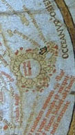
- Senex
Map of North America (1710)—a
British attempt to consolidate information about the continent which presents
known areas in great detail but leaves unknown areas almost undefined, except
for an indication of a Northwest Passage via the Missouri River. At the Exploring
the West from Monticello website homepage, click "Related Resources
on the WWW," then click "Rare Map Collection." Select "Colonial
America” and scroll down and select Map
1710 S4: North America.
- Arrowsmith's
"New Discoveries" (1795) -- a map of the western North American interior
that represents the natural geography of the region almost exclusively and
shows not only its vast expanse but also an unbroken mountain range separating
east from west. Unexplored areas are virtually blank, yet there is still a
suggestion of a Northwest Passage via the Missouri River. At the Exploring
the West
from Monticello website homepage, click "To the Western Ocean: Planning
the Lewis and Clark Expedition," then scroll down and click Aaron
Arrowsmith, A Map Exhibiting All the New Discoveries in the Interior Parts
of North America.
- The
Lewis and Clark Track (1810) -- based on the maps William Clark produced
during the expedition, this map also records mainly the natural geography
of the American West, with an emphasis on the abundance of navigable waterways
which may give the impression that there is a passage to the Pacific. At the
Lewis
& Clark: The Voyage of the Corps of Discovery website homepage, click
"The Archive," then select "Maps" and click Map
of Lewis and Clark Track.
5
Have each study group share its observations on each map
and on the relationships between them in an informal report, then discuss as a
class the sequence traced by these maps, exploring the points below:
- How do hopes or expectations influence these mapmakers?
Note, for example, how the Senex map resists extending the Rocky Mountains north
and south from their known positions to create a barrier across the continent,
and how even Arrowsmith thins the mountain range where it is unexplored while
showing it as an imposing obstacle elsewhere. Clark, who had crossed that range,
details its rigors, but his meticulous attention to waterways might be seen as
a lingering hope for transcontinental transport despite the mountains.
- How
do cultural assumptions influence the mapmakers in their choice of landmarks?
Which details of the region do they consider significant? For example, note in
this regard how Arrowsmith, in contrast to the Speed map of 1627, excludes all
but natural landmarks. To what extent is this scientific objectivity, to what
extent does it imply that this region is an uninhabited wilderness? The same question
arises even more insistently with regard to Clark's map, since he was obviously
aware that the region was already settled by Native Americans. Are cultural assumptions
at work here -- assumptions about the demands of science or the rights of nations
-- eliminating all trace of the region's people from these maps?
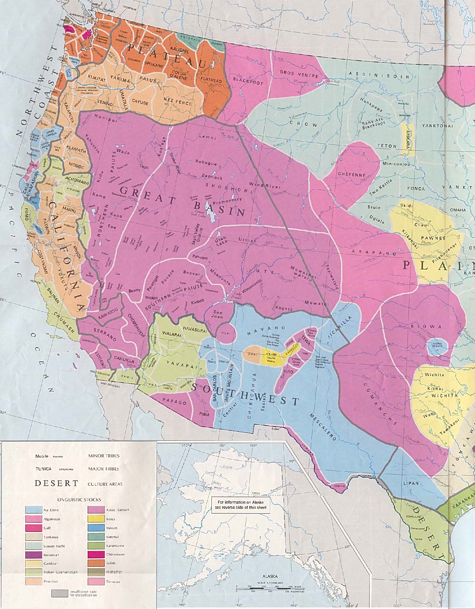
- To provide a counterview of the region, showing it
as a land not only inhabited but possessed by different tribal groups, share
with students an ethnographic map of the America West before westward expansion
at the Early
Indian Tribes, Culture Areas, and Linguistic Stocks, Western U.S.
6 Conclude
this lesson by having students individually collect different kinds of present-day
maps of the world and/or the United States -- road maps, vacation maps, political
maps, satellite-image maps, computer-generated maps, ecological maps, etc. Let
the class choose several examples from this collection for study using the "Map
Analysis Worksheet" to find out what our maps might reveal about our world view
and our assumptions about our relationship to our world.
Extending the Lesson
Historical maps can open an exciting chapter in the history
of technology and science. For background on the scientific mapmaking skills used
by Lewis and Clark, visit Exploring
the West from Monticello on EDSITEment, and click Observations
of Latitude and Longitude at All Remarkable Points on the website's homepage.
For information on Galileo's efforts to improve navigation, visit The
Galileo Project, click "Observing Terrace" on the website's homepage, and
select Longitude
at Sea.
Standards Alignment
View your state’s standards
|

