| Subject Areas |
|
History and Social Studies
|
| |
U.S. History - Native American |
| |
U.S. History - The West |
| |
| Time Required |
| | Each part of the lesson plan requires two to three class periods.
Each part is a free-standing lesson adaptable as a curriculum supplement.
|
| |
| Skills |
| | map reading
interpretation of informative writing and imaginative literature
chronological thinking
historical comprehension
historical research
comparative analysis
interpretation of visual art
imaginative writing
library and Internet research skills
|
| |
| Date Posted |
| | 4/8/2002 |
| |
| Feedback |
| |
Send us your thoughts about this lesson! |
| |
| Email this Lesson |
| |
Send this lesson to friends or colleagues |
| |
|

|
Life on the Great Plains
Introduction
In this four-part lesson, students examine
the concept of geographic region by exploring the history of
the Great Plains. In Part I, students gather information about
the location and environment of the Great Plains in order to
produce a map outlining the region in formal terms. In Part
II, students examine how the region has been mapped at different
stages in U. S. history and create informational brochures which
reflect the changes the maps mark in the functional definitions
of the Great Plains. In Part III, students compare descriptions
of the region, from the time of the Spanish conquistadors to
the early 20th century, and write their own descriptions based
on these models in order to gauge how changing perceptual definitions
of a region reshape its identity and its relationship to human
life. Finally, in Part IV, students compare images of two cultures
that made their homes on the Great Plains, Native Americans
and "sodbusters," and summarize their distinct ways of life
and the distinctive regional identity each brought to the Great
Plains by writing imaginary letters from a Native American and
a sodbuster homesick for the land they have left behind.
Learning Objectives
To explore the concept of region and
learn how culture and experience influence the perception
of regions; to investigate the relationships between physical
geography and human systems of culture and settlement; to
trace the history and character of a region as reflected in
literature and art; to examine factors that influenced westward
expansion in the United States.
PART I: Defining the Region
1
Begin by introducing the geographical concept of "region."
In general, a region is any place that has certain characteristics
that give it a measure of cohesiveness and set it apart from
other regions. By this definition, a region can cover continents
(e.g., the developing world) or a few city blocks (e.g., Wall
Street). Whatever their scale, however, regions are essentially
human constructs whose boundaries are determined by specific
criteria.
- Geographers define regions in three ways, depending
on the type of criteria used to set their boundaries. A formal definition
of a region points to human or physical properties of the place, such as a
shared language or common landform. A functional definition describes
a region in terms of human purposes, which may be evident in a transportation
network or pattern of commerce. Finally, a perceptual definition of
region refers to shared attitudes or emotions toward a place, which may be
expressed in a name like "Dixie" or "The Big Apple." The distinction between
formal, functional, and perceptual definitions of a region provides a framework
for this lesson plan.
- For additional background on the concept of region, refer to the “Places
and Regions” chapters (Standards 4, 5 and 6) in the “Standards”
section of the National
Geographic Society Xpeditions website, from which the explanations provided
here are drawn. (Click on “Standards” at the Xpeditions
homepage, then click “See the Standards” and choose Standards
4, 5 and 6.)
- Students also can learn about the concept of region
through several of the interactive exhibits in "Xpedition Hall" at the National
Geographic Society Xpeditions website. The Satellite
Spyglass exhibit dramatizes how regions can vary in scale with a series
of satellite images that zoom in from a continent-wide view of the United
States to a single block in Washington, D.C. The Culture
Goggles exhibit illustrates the influence of culture on the perception
of a region by showing visitors how the most important landmarks in Jerusalem
shift as one looks at the city from a Jewish, a Christian, and an Islamic
point of view. (To locate these exhibits, click on "Xpedition Hall" at the
Xpeditions
homepage, then use the interactive "floorplan" at the right of the screen
to select "X5: Satellite Spyglass" or "X6: Culture Goggles" in the "II: Places
and Regions" wing of the hall.)
2
Explain that in this lesson students
will use the concept of region to explore the history of the
Great Plains, an area that early maps labeled the Great American
Desert but which is known today as a showcase for American
agriculture.
- Use the "Atlas" at the National
Geographic Society Xpeditions website to obtain a reproducible outline
map of the "United States." (Click on "Atlas" at the Xpeditions
homepage, then click on "North America" in the interactive map of the world,
and click on "United States" in the interactive map of North America. Before
printing out the map, select "detailed" with borders "on" at the top of the
frame.) Give each student a copy of the map and have them mark on it the region
they think of as the Great Plains.
- Compare the students' maps and discuss
the element of interpretation that enters into the definition
of a region. Focus on areas where their definitions of the
region differ. Why did some students include an area that
other students excluded? What characteristics of that area
make it seem part of the Great Plains to them? Focus also
on areas where there is agreement. What are the characteristics
of these areas that lead most members of the class to identify
them as part of the Great Plains? List these defining characteristics
on the chalkboard. How far could one push the boundaries
of the Great Plains using these criteria?
3
Divide
the class into research teams, provide each team with a fresh
copy of the outline map of the United States, and have them
produce maps of the Great Plains based on the geography of
the region. Have each team note and/or represent on its map
the formal characteristics they use to define this
region: for example, landform, climate, average rainfall,
vegetation, land use, population density, etc. Direct students
to standard library reference works for their research. In
addition, two websites listed in the "Resources and Links"
section of the National
Geographic Society Xpeditions website may be helpful.
(Click on "Resources and Links" at the Xpeditions
homepage to reach this listing.)
4
Display the students' maps and again
discuss similarities and differences, focusing this time on
the formal characteristics that students have used to define
the Great Plains.
- How large is the region if landform
is the only defining characteristic? How are the outlines
of the region affected by adding climate as a defining characteristic?
Or population density? How important are political borders
as defining characteristics? What is gained by defining
the region broadly, as an area stretching from deep in Canada
to north Texas? What is gained by defining it more narrowly?
- If students have referred to satellite
images in their research, ask them to compare these images
to standard descriptive maps. What kinds of information
are missing from the satellite view? How are these images
helpful and/or misleading for defining a region?
- Finally, ask students to speculate
whether all the people living inside the boundaries they
have marked would say that they live in the Great Plains
region. Why or why not? How important are such cultural,
social, and political perceptions to the definition of a
region?
PART II: Mapping the Territory
1
Turn next to consider the influence that human purposes have
played in defining the Great Plains as a region. Use EDSITEment
to examine these historical maps from the New
Perspectives on THE WEST and the Exploring
the West from Monticello websites:
2 After students have
examined and compared these historical maps, ask them to consider their significance.
To what extent are these maps functional definitions of the Great Plains
region -- portraying it as an area organized by human purposes at a specific
moment in American history? To help students see the maps from this perspective,
ask them who the maps were made for and how they characterize the region. What
do they "say" about the Great Plains? For example, you might point out that:
- The 1795
map represents the Great Plains as a trackless space, a view that stems
not only from the mapmaker's lack of knowledge but also, perhaps, from the
perception that this part of North America would serve mainly as a pathway
to the Pacific. The Lewis
and Clark map, by contrast, portrays the Great Plains as a region criss-crossed
by waterways, which provide a ready means of transportation and make it seem
a promising area for settlement. This view may stem in part from Lewis and
Clark's failure to discover a water passage to the Pacific, but it reflects
also their firsthand observation of the land and its resources.
- In the maps of Indian territories,
the Great Plains is once again a nearly blank space, large
enough to hold all the displaced tribes but without any
features that might make it appealing to non-Native Americans.
The territories assigned to each tribe are merely zones,
with nothing to suggest that natural resources might make
one zone preferable to another. It is noteworthy, however,
that on the 1851
map, which was drawn up in consultation with the tribes
involved, territorial borders reflect the natural contours
of the region, its rivers and ranges, whereas on the 1836
map territories are marked out with a ruler.
- In the 1880s maps of individual
Great Plains states, the region is portrayed as "inhabited"
territory. Towns and forts dot the landscape, political
boundaries give each part of the region a name, and in addition
to rivers and streams, there are railroads connecting the
Great Plains to more settled parts of the United States.
In this view, the region appears as open land awaiting development,
and it is perhaps significant that the mapmaker has included
the Native Americans of the Great Plains almost as natural
features of the region rather than mark off the boundaries
of their individual reservations. Instead of landholders,
they seem part of the scenery.
3
Following
your discussion of the historical maps, divide the class again
into small groups and have each group produce an informational
brochure about the Great Plains based on one of the historical
maps. Their brochures should express in words and pictures
the implicit message behind each map -- its functional
view of the Great Plains -- and should reflect the circumstances
of American history under which each map was produced. A brochure
for the Lewis and Clark map, for example, might encourage
entrepreneurs to discover for themselves the riches of the
region, while a brochure based on one of the 1880s state maps
might advertise the availability of extensive tracts located
near major rail lines. When they have completed their brochures,
have students share these historical interpretations of the
Great Plains in infomercial-style class presentations.
PART III: A Sense of Place
1 To explore how human
perceptions have defined the Great Plains, use EDSITEment to provide students
with descriptions of the region from a variety of time periods and perspectives.
The examples suggested here fall into three sets—explorers, emigrants,
and settlers. It may be convenient to divide the class into three groups and
have each group compare and report on one set of descriptions.
Explorers
- Coronado,
the first European to travel through the Great Plains, included
a description of the region in his 1541
Letter to the King, which explains why he failed to
discover the fabled Cities of Gold. This letter appears
with other accounts of Coronado's expedition in the archive
for Episode
One in the Archives
of THE WEST section of New
Perspectives on THE WEST.
- Lewis
and Clark, who opened the Great Plains to American
settlement, included many descriptions of the region in
their journals, which are accessible in the Archive
section of the Lewis
and Clark: The Journey of the Corps of Discovery
website. Click on The
Journals, find the search engine, and type in "September
17, 1804" to retrieve the entry in which Meriwether Lewis
describes his first walk across the plains.
Emigrants
Settlers
- Farmers arrived on
the Great Plains in the 1870s, many drawn by railroad company advertisements
that portrayed it as a green oasis. The settlers' most picturesque descriptions
of the region appear in folk songs like "Lane Country Bachelor" and "Dakota
Land" (also known as "Nebraska Land"). Texts of these two songs are available
at the
National Geographic Society Xpeditions website in a lesson plan entitled
"The
Great Plains: A Harsh Welcome to Settlers?" upon which this lesson
plan is partly based.
- Ranchers
also settled on the Great Plains in the wake of railroad
expansion, and their perception of the region can be found
in Theodore Roosevelt's Ranch
Life and the Hunting Trail, an account of his days
in the Dakotas. This book is available in the archive for
Episode
Seven in the Archives
of THE WEST section of New
Perspectives on THE WEST; see Chapter
1 for a cattleman's view of the plains.
- Writers
who grew up on the Great Plains in the late-19th century
provide an imaginative perspective on the region. See the
stories of Hamlin Garland collected in Main-Travelled
Roads (1922) for a perspective darkened by an awareness
of the hardships of life on the Great Plains; Willa Cather's
novel, My Antonia (1918), for a view evocative of
the spiritual strength this implacable landscape could impart;
and Carl Sandburg's poem "Prairie"
(1918) for an epic view celebrating the picturesque beauties
of the region. (Sandburg's poem is available at the American
Verse Project website on EDSITEment; type "prairie"
into the website's search engine to retrieve the text.)
2
As
students read these accounts of the Great Plains, have them
take notes on the natural features mentioned and the descriptive
terms and adjectives used. In class discussion, compare notes
to determine which features are consistently mentioned across
the centuries and how they are characterized in different
time periods. Focus also on each writer's portrayal of the
relationship between people and the world of the Great Plains.
What brings people to the region in each era, and how does
this purpose influence their perception of the landscape and
climate, the animal and plant life, the native inhabitants?
How, too, does the writer's place in the historical procession
across the Great Plains influence his or her perception of
its landmarks and defining features?
3
Students
will find that few of these writers offer set descriptions
of the Great Plains, reporting instead on what happens there.
Yet each writer to some degree expresses an attitude toward
the region, provides us with a point of view that imparts
a significance to this space on the map. Have students summarize
these viewpoints by writing a description of the Great Plains
modeled on one writer from each set of readings: an explorer,
an emigrant, and a settler. Have students draw on the vocabularies
they have gathered from their reading to give three historically
relevant portraits of the region. As an alternative, have
students create an anthology of Great Plains writings, adding
examples to those listed above, and write an introduction
to each section of the anthology explaining how changing perceptions
of the Great Plains throughout U. S. history have redefined
the region.
PART IV: A Way of Life
1
To
conclude this exploration of the Great Plains, turn to visual
portrayals of life in the region. Like written descriptions,
paintings and photographs convey a point of view, influenced
by the culture and experience of the person making the image.
In this respect they offer a complementary record of the way
perceptions of the Great Plains have evolved over the centuries.
At the same time, paintings and photographs provide an important
supplement to the written record in their ability to convey
the Native American experience on the Great Plains, whether
directly through images created by Native Americans or indirectly
through documentary images created by white observers.
2
Use EDSITEment to provide students with
a selection of images that represent Native American life
on the Great Plains. For example, in the Archives
of THE WEST section of New
Perspectives on THE WEST you will find:
- Buffalo
Chase, an early 19th-century painting of mounted Plains
Indians hunting buffalo by the anthropologist-artist George
Catlin. (This image is part of the archive for Episode
One.)
- A Shoshone
elk hide portraying a mounted buffalo hunt and the dance
performed to bring the hunters good luck. (This image is
also part of the archive for Episode
One.)
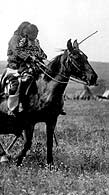
- A photograph of a Lakota
encampment in the Pine Ridge area of the Dakota plains,
taken in 1891. (This image is part of the archive for Episode
Six.)
3
Ask
students to identify common features in these three images.
They will probably point out the horse, which is the only
feature that all three images share. Have students suggest
reasons why the horse should be, in effect, a defining characteristic
of traditional Native American life on the Great Plains. Encourage
students to base their explanations on the knowledge of Great
Plains geography that they gained by mapping the region. How
did the horse help the Indians adapt to and survive in this
environment? How did it alter their perspective on the space
around them? To what extent might one see the horse as an
embodiment of the Plains tribes' relationship to their region?
4 To help clarify this
composite picture of Native American life on the Great Plains, have students
examine images of late-19th-century settlers in the region.
5
Have students contrast these images
of sodbusters with those portraying Native Americans. Point
out the sod house as a constant feature of the settlers' way
of life, comparable in this respect to the horse in the pictures
of Native American life. Ask what the sod house suggests about
the settlers' relationship to the world of the Great Plains.
How did it help them adapt to and survive in this environment?
How did it influence their perspective on the space around
them? Have students compare the sod house and the horse as
characterizing features of the Great Plains region. How do
these competing "landmarks" influence our understanding of
this place? How does the significance of the Great Plains
shift in history as the culture of the horse gives way to
that of the sod house? In what other respects do these two
sets of images show how cultural values influence people's
perceptions of a region and the life they fashion within it?
6
Remind students that they have examined
only a small sampling of images of life on the Great Plains.
Discuss briefly how they might test their interpretations
through further research. Then ask students to summarize their
interpretations of the Native American and the sodbusters'
way of life by writing two letters, one from an Indian, the
other from a settler, both homesick for the region they have
left behind. What details of the natural landscape do these
imaginary writers mention in their letters? What routines
of living on the Plains do they recall? What questions do
they ask to find out how things have changed there?
Extending the Lesson
Like the land itself, the history of the Great Plains can
seem endless. For additional perspective on the region:
- Explore the NativeWeb
website for resources on the history and present-day life of Native Americans
of the Great Plains. At the website's homepage, click on Geographic
Region Index, then select US
- Central for a list of links to websites maintained by the Cheyenne
River Sioux and other Great Plains tribes.
- Visit the ArchNet
website for resources on the mammoth hunters who roamed the Great Plains in
prehistoric times, as well as the Mandan and other early tribes of the upper
Missouri whose way of life was based on agriculture and trade. At the website's
homepage, click on Regional
View, then click on North
America in the interactive world map. Click on “American
Midwest”, then scroll down the list of "Midwest" links
for the South Dakota State Archeological
Research Center.
- Go to the New
Deal Network website for documents and images from the "Dust Bowl" era,
when drought and the Great Depression combined to drive thousands from the
Great Plains in an exodus John Steinbeck portrayed in The Grapes of Wrath
(1939). Look in the website's Document
Library for the Report
of the Great Plains Drought Area Committee , and in the Photo
Gallery for images of Dust
Bowl life.
- Research one way the competiton for resources has
influenced life on the Great Plains by visiting the Evolution
of the Conservation Movement, 1850-1920 collection at the American
Memory website. Documents here highlight in particular how seemingly enlightened
policies, aimed at preserving wildlife and natural landmarks, inevitably threatened
tribes who regarded the region's wildlife as a food source and its natural
landmarks as sacred places. Compare this conflict between competing perceptions
of the region to controversies that arise when urban preservationists identify
a neighborhood as historic and work to impose their views on its inhabitants'
way of life.
Standards Alignment
View your state’s standards
|