
 Feeds & Data
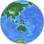
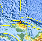
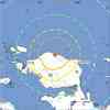
Magnitude 7.6 - NEAR THE NORTH COAST OF PAPUA, INDONESIA
2009 January 03 19:43:50 UTC
Earthquake Details
| Magnitude | 7.6 |
|---|---|
| Date-Time |
|
| Location | 0.408°S, 132.886°E |
| Depth | 17 km (10.6 miles) set by location program |
| Region | NEAR THE NORTH COAST OF PAPUA, INDONESIA |
| Distances | 145 km (90 miles) WNW of Manokwari, Papua, Indonesia 185 km (115 miles) ENE of Sorong, Papua, Indonesia 1350 km (840 miles) N of DARWIN, Northern Territory, Australia 2970 km (1840 miles) ENE of JAKARTA, Java, Indonesia |
| Location Uncertainty | horizontal +/- 6.3 km (3.9 miles); depth fixed by location program |
| Parameters | NST=240, Nph=240, Dmin=>999 km, Rmss=1.26 sec, Gp= 36°, M-type=regional moment magnitude (Mw), Version=V |
| Source |
|
| Event ID | us2009bjbn |
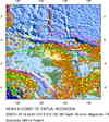
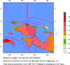
- This event has been reviewed by a seismologist.
- Did you feel it? Report shaking and damage at your location. You can also view a map displaying accumulated data from your report and others.
Earthquake Summary
Felt Reports
At least four people killed at Manokwari and one killed at Sorong. At least 250 people injured, 840 buildings damaged and power outages in West Papua. Felt (VI) at Manokwari and Sorong; (IV) at Nabire and Ransiki.
Tectonic Summary
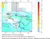
The magnitude 7.6 Papua, Indonesia earthquake of January 3, 2009, 19:43 UTC, occurred as a result of thrust faulting on a plate-boundary along the northwest coast of the island of New Guinea. Eastern Indonesia is characterized by complex tectonics in which motions of numerous small plates are accommodating large-scale convergence between the Australia, Pacific, and Eurasia plates. In broad-scale plate-tectonic models that do not subdivide continent sized plates into smaller plates, the location of today's earthquake would be on the boundary of the Pacific and Australia plates. The Pacific plate (located north and northeast of the epicenter) is moving southwest with respect to the Australia plate (located south of the epicenter) with a velocity of about 112 mm/year at the epicenter of the earthquake, and the focal-mechanism of today's earthquake is broadly consistent with Pacific plate lithosphere being subducted beneath Australia plate lithosphere. The subduction zone along the northwest coast of New Guinea is characterized by an offshore oceanic trench, the New Guinea trench, but teleseismically recorded earthquake hypocenters do not show a well-developed inclined seismic zone (a Wadati-Benioff zone) dipping south-southwest from the trench.
The earthquake of January 3, 2009, 19:43 UTC, occurred about 470 km west of the magnitude 8.2 earthquake of February 17, 1996. The 1996 earthquake produced a tsunami that was destructive on the island of Biak. At least 108 people were killed by the 1996 earthquake and associated tsunami.
Earthquake Information for Indonesia
 Tsunami Information
- NOAA West Coast & Alaska Tsunami Warning Center
- NOAA Pacific Tsunami Warning Center
- Tsunami Information Links
The earthquake locations and magnitudes cited in these NOAA tsunami bulletins are very preliminary and may be superceded by USGS locations and magnitudes computed using more extensive data sets.
Earthquake Maps

Scientific & Technical Information

Additional Information, News Reports
- Preliminary Earthquake Report
- U.S. Geological Survey, National Earthquake Information Center:
World Data Center for Seismology, Denver
