
|
projects > hydrologic monitoring in joe bay
Hydrologic Monitoring in Joe Bay
Summary
|
| The current monitoring network in Joe Bay can assist with determining the effect upstream restoration efforts have on the timing and distribution of freshwater flows into northeastern Florida Bay. |
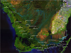
Joe Bay is the primary hydrologic connection between the freshwater Everglades and northeastern Florida Bay. Flow and salinity monitoring by the U.S. Geological Survey (USGS) has determined that Trout Creek is the largest contributor of freshwater flow to northeastern Florida Bay and is connected to Joe Bay. Sources of freshwater to Joe Bay include Taylor Slough and the C-111 Canal. Hydrologic parameters such as water level, discharge, and salinity observations in conjunction with water quality sampling have been useful in determining contributions of freshwater flow from Taylor Slough and C-111 Canal to Joe Bay. Hourly salinity data has been collected at four locations in Joe Bay since May 1999. In 2001, three index velocity stations were installed at Joe Bay 2E, Joe Bay 5C, and Joe Bay 8W . The current monitoring network in Joe Bay can assist with determining the effect upstream restoration efforts have on the timing and distribution of freshwater flows into northeastern Florida Bay. As the Comprehensive Everglades Restoration Plan (CERP) moves towards implementation, the need for baseline data for projects such as the C-111 Spreader Canal Project is critical.  | | Map showing locations of Joe Bay study area and sites. [larger version] |
| 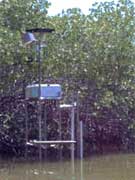 | | Joe Bay collection station |
|
Proposals
Data
Metadata
Publications
Abstracts
Digital Data Series
Fact Sheets
Posters
Reports
- 2006 Water Resources Data for the United States Water Year 2006 (Search all reports for the year. Please note individual manuscript files that follow are PDF files which require the FREE Adobe Acrobat Reader® to be read.)
- 2006 Southern Florida Basin, Big Cypress Swamp Subbasin: 02290928 Barron River at Everglades City, FL (PDF file)
- 2006 Southern Florida Basin, Big Cypress Swamp Subbasin: 02290930 Turner River Near Chokoloskee Island, FL (PDF file)
- 2006 Southern Florida Basin, Big Cypress Swamp Subbasin: 02290940 New River at Sunday Bay, FL (PDF file)
- 2006 Southern Florida Basin, Big Cypress Swamp Subbasin: 02290942 Lopez River Near the Lopez Campsite, FL (PDF file)
- 2006 Southern Florida Basin, Everglades Subbasin: 022908205 North River Upstream of Cutoff Near Flamingo, FL (PDF file)
- 2006 Southern Florida Basin, Everglades Subbasin: 022908295 Bottle Creek at Rookery Branch Near Homestead, FL (PDF file)
- 2006 Southern Florida Basin, Everglades Subbasin: 02290878 Broad River Near the Cutoff, FL (PDF file)
- 2006 Southern Florida Basin, Everglades Subbasin: 02290888 Chatham River Near the Watson Place , FL (PDF file)
- 2006 Southern Florida Basin, Everglades Subbasin: 02290918 Lostman's River Below Second Bay, FL (PDF file)
- 2006 Southern Florida Basin, Everglades Subbasin: 251003080435500 McCormick Creek at Mouth, FL (PDF file)
- 2006 Southern Florida Basin, Everglades Subbasin: 251032080432200 Seven Palm Lake Near Flamingo, FL (PDF file)
- 2006 Southern Florida Basin, Everglades Subbasin: 251105080231800 Jewfish Creek at U.S. 1, Key Largo, FL (PDF file)
- 2006 Southern Florida Basin, Everglades Subbasin: 251127080382100 Taylor River at Mouth Near Homestead, FL (PDF file)
- 2006 Southern Florida Basin, Everglades Subbasin: 251209080350100 Mud Creek at the Mouth Near Homestead, FL (PDF file)
- 2006 Southern Florida Basin, Everglades Subbasin: 251241080385300 Upstream Taylor River Near Homestead, FL (PDF file)
- 2006 Southern Florida Basin, Everglades Subbasin: 251253080320100 Trout Creek at Mouth, FL (PDF file)
- 2006 Southern Florida Basin, Everglades Subbasin: 251322080352500 Joe Bay 8W Near Key Largo, FL (PDF file)
- 2006 Southern Florida Basin, Everglades Subbasin: 251338080312600 Joe Bay 1E Near Key Largo, FL (PDF file)
- 2006 Southern Florida Basin, Everglades Subbasin: 251341080291200 Stillwater Creek Near Homestead, FL (PDF file)
- 2006 Southern Florida Basin, Everglades Subbasin: 251355080312800 Joe Bay 2E Near Key Largo, FL (PDF file)
- 2006 Southern Florida Basin, Everglades Subbasin: 251422080271900 Oregon Creek Near Key Largo, FL (PDF file)
- 2006 Southern Florida Basin, Everglades Subbasin: 251433080265000 West Highway Creek, FL (PDF file)
- 2006 Southern Florida Basin, Everglades Subbasin: 251438080333500 Joe Bay 5C Near Key Largo, FL (PDF file)
- 2006 Southern Florida Basin, Everglades Subbasin: 251440080262800 East Highway Creek Near Key Largo, FL (PDF file)
- 2006 Southern Florida Basin, Everglades Subbasin: 251457080395800 Taylor Slough Wetland at E146 Near Homestead, FL (PDF file)
- 2006 Southern Florida Basin, Everglades Subbasin: 251549080251200 Manatee Bay Creek Near Homestead, FL (PDF file)
- 2006 Southern Florida Basin, Everglades Subbasin: 251740080311200 C-111 Wetland Near Homestead, FL (PDF file)
- 2006 Southern Florida Basin, Everglades Subbasin: 251816080232200 Card Sound Canal Near Homestead, FL (PDF file)
- 2006 Southern Florida Basin, Everglades Subbasin: 252019080544800 Upstream North River Near Flamingo, FL (PDF file)
- 2006 Southern Florida Basin, Everglades Subbasin: 252230081021300 Shark River Near Gunboat Island Near Flamingo, FL (PDF file)
- 2006 Southern Florida Basin, Everglades Subbasin: 252551081050900 Harney River Near Flamingo, FL (PDF file)
- 2006 Southern Florida Basin, Everglades Subbasin: 253044080555900 Eden 3 in Everglades National Park, FL (PDF file)
- 2006 Southern Florida Basin, Everglades Subbasin: 253357080594100 Upstream Lostman's River Near Everglades River, FL (PDF file)
Water Resources Investigations Reports
Photos
|


 South Florida Coastal Real-Time Surface Water Stations