Ground Water Characterization in Marine Areas of Biscayne National Park
|
Project Investigator:
Robert B. Halley (retired)
Project Personnel: Peter Swarzenski, Chris Reich, Richard Curry, Don Hickey Project Start Date: 2000 End Date: 2004 |
| Summary |
| This study will be the first to advance the knowledge of groundwater movement in offshore settings where onshore hydraulic gradients may influence offshore flow and furthermore, where tidal pumping complicates groundwater flow. |
This project is funded by the USGS Coastal and Marine Program and the National Park Service.
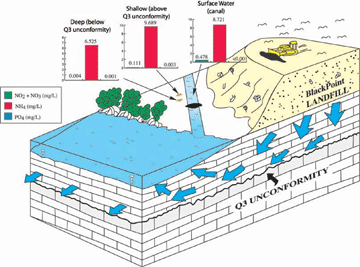
Biscayne National Park is a marine park that sits immediately adjacent to a metropolitan area consisting of over one million people. Development of the shoreline and nearby upland areas is extensive and natural upland water flow has been radically altered through a broad system of drainage canals and dredged waterways. Numerous deeply dredged ponds, lakes, and water storage sites, which collect and hold urban surface run-off, also occur on the adjacent upland areas. Infiltration and spread of non-point source pollutants into the groundwater system from surface run-off and these dredged sites is likely to be significant with the highly porous limestone substrate of the region known as the Biscayne Aquifer. This aquifer flows directly into Biscayne Bay. In addition, a large Metropolitan Dade County trash dumping facility was established during the 1970's in an area immediately adjacent to Biscayne Bay and the Park. This facility has resulted in a very large mound (mountain) of municipal waste being created, which has a very large potential for groundwater impact and subsurface flow of contaminants into the Park. Some groundwater infiltration of nutrients (Figure 1) and contaminants from the urban developments and the municipal waste facility have been documented. However, the extent to which these contaminants are flowing and resurfacing into Biscayne Bay and offshore reef area waters has not been determined. According McNeill (2000), 10 of the 17 injection wells at the Miami-Dade Water and Sewer South District plant were constructed improperly creating a relatively open pathway for upward migration of injected effluent. As a result, ammonia was detected in shallow monitoring wells within 11 years of first injection. This varies significantly from the originally calculated 343 years for upward migration of effluents. Recent declines in offshore coral reef health may be linked to groundwater pollution or due to surface water quality declines, or possibly other ecosystem stress factors. The park needs to better understand the current extent of groundwater pollution and its possible affects on park resources in order to make correct management decisions concerning the loss of park marine resources.
|
Specific Objectives to be Addressed
This project is designed to use both geochemistry and hydrogeology to identify whether or not ground water is migrating through coastal aquifers offshore into Biscayne Bay and nearby reef tract. The approach has two objectives.
Objective one is to use water quality (geochemistry) as an identifier for water mass signature. Using geochemical tracers such as isotopes of radon and radium and cations/anions (e.g., calcium, magnesium) can help identify certain water masses. Other water quality parameters are necessary in understanding potential sources of contamination to the ecosystem. Air and surface water sources are relatively easy to investigate but ground water beneath a marine system is much more difficult to access. This project will quantify water quality parameters such as nutrients (nitrogen and phosphorus species), trace elements (e.g., zinc, copper, arsenic), wastewater compounds (e.g., 17beta-estradiols, coprostanol, caffeine, surfactants), pesticides (e.g., Lindane, Endosulfan, DDT), as well as field parameters (pH, dissolved oxygen, salinity, temperature). These parameters will help characterize the ground water beneath Biscayne Bay and provide some index as to the potential threat for contaminating surface waters within BNP.
Our second objective is an academic understanding of the flow regime beneath Biscayne Bay and within Biscayne National Park. Groundwater flow is driven by changes in water level (potentiometric surface gradient) in the adjacent Biscayne Aquifer. Potentiometric surfaces for ground water have been investigated extensively for onshore regions of south Florida and to some extent for the coastline, but no information exists farther offshore. To complicate natural flow gradients, tidal pumping is known to create flow patterns in marine ground waters. Although tidal pumping has been investigated using seepage meters, it is most accurately quantified by using observation wells. Determining the pressure gradients produced between ground water and surface water by the action of tidal pumping can potentially provide data on vertical and horizontal groundwater movement.
Publications
Open File Reports
- U.S. Geological Survey Science Support Strategy for Biscayne National Park and Surrounding Areas in Southeastern Florida (OFR 2007-1288, available from the U.S. Geological Survey website)
Reports
- Groundwater Characterization and Assessment of Contaminants in Marine Areas of Biscayne National Park (Technical Report NPS/NRWRD/NRTR-2006/356)


