 |
 | |
  | |
|
|
|
|
Great Smoky Mountains National Park
Photos & Multimedia
|
|
|
|
|
| |
 |
WebCams Two webcams provide a current view of the park and information about air quality conditions. Images are updated every 15 minutes.
Look Rock (located on the western end of the park)
Purchase Knob (located on the eastern end of the park)
|
Podcasts
The Great Smoky Mountains Association, a non-profit partner of the park, offers free podcasts from the Smokies, including stories, songs, and the Newfound Gap Self-guiding Auto Tour. Visit their website for or .
|
Seasons in the Smokies
|
|
|
Autumn - Along Newfound Gap Road

|
Autumn - Bull Head
|
Autumn - Cades Cove Fields
|
|
Autumn - Cataloochee Creek

|
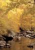
Autumn - Golden Colors Reflected in Stream
|
Autumn - Heintooga Ridge Road

|
|
Autumn - Leaf Colors at Newfound Gap

|
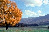
Autumn - Maple at Cable Mill

|
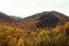
Autumn - Mountain View
|
|
|
|  | | |
|
|

Wildlife Watching
Open areas such as Cades Cove and Cataloochee are good places to view wildlife.
more... | | 
Download Park Maps
Maps of trails and campgrounds as well as general park maps are available.
more... | | 
Auto Touring
Auto Touring is a popular way to explore the park.
more... | | 
When Will It Snow?
Snow falls infrequently in the foothills, but at high elevation, snow is more common.
more... | |
|
|
|
|
|
|
|
 |
|
Did You Know?
At 480 feet, Fontana Dam, located on the southwestern boundary of the park, is the tallest concrete dam east of the Rocky Mountains. The dam impounds the Little Tennessee River forming Fontana Lake and produces hydroelectric power.
|
|
|
|
Last Updated: September 17, 2008 at 12:26 EST |

