
 Feeds & Data
Magnitude 5.4 - GREATER LOS ANGELES AREA, CALIFORNIA
2008 July 29 18:42:15 UTC
Earthquake Details
| Magnitude | 5.4 |
|---|---|
| Date-Time |
|
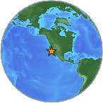
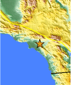
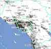
| Location | 33.953°N, 117.761°W |
| Depth | 14.7 km (9.1 miles) |
| Region | GREATER LOS ANGELES AREA, CALIFORNIA |
| Distances |
|
| Location Uncertainty | horizontal +/- 0.2 km (0.1 miles); depth +/- 0.3 km (0.2 miles) |
| Parameters | Nph=181, Dmin=9 km, Rmss=0.33 sec, Gp= 18°, M-type=moment magnitude (Mw), Version=S |
| Source | |
| Event ID | ci14383980 |
- This event has been reviewed by a seismologist.
- Did you feel it? Report shaking and damage at your location. You can also view a map displaying accumulated data from your report and others.
Earthquake Summary
Felt Reports
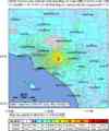
Felt (VI) at Anaheim, Brea, Covina, Dimond Bar, Fullerton, Garden Grove, La Puente, Montclair, Pamona, Placentia, San Dimas, Walnut, West Covina and Yorba Linda. Felt throughout the Los Angeles Basin area and in much of southern California. Felt as far away as Las Vegas, Nevada and Yuma, Arizona.
Tectonic Summary
--Version 02: 3:47 pm 04 August 2008--
A Mw5.4 main shock-aftershock sequence started 2 miles southwest of Chino Hills, in the Chino Hills at a depth of about 9 miles, in the east Los Angles area at 11:42am on Tuesday, July 29, 2008. The main shock was followed by a M3.8 aftershock at 11:52am. In the first two hours, 37 smaller aftershocks were also recorded in the magnitude range of 1.3 to 2.8.
A 2nd M3 aftershock of M3.6 aftershock occurred at 1:41 pm.
The sequence was felt across southern California. Strong shaking was reported to the north in the Chino Basin and to the southwest in the Los Angles basin. About 30,000 people had responded as having felt the earthquake, approximately 2 hours following the earthquake.
It is not possible to tell at this time what fault caused the earthquake. It is located half-way in between the Whittier and Chino fault. The moment tensor showed a mixture of thrust and left-lateral strike-slip faulting on a plane striking 43 deg east of north, forming a high angle to both faults. This plane has a dip of 58 deg and rake of 43 deg. The preliminary locations of the aftershocks suggest that this is the fault plane. A southwest trend of small earthquakes extending across this region into the Los Angles basin was identified in 1990 and called the Yorba Linda trend.
The auxiliary plane has a strike of 291 degrees, dip of 59 degrees, and rake of 142 degrees. This plane has the same strike as the Whittier fault, and day-lights out at the mapped fault. However, the mapped dip of the Whittier fault is 82 deg while the earthquake has a dip of 59 degrees. Also, the preliminary distribution of aftershock depths does not support the Whittier fault being the causative fault. Further research is needed to determine the causative fault.
This earthquake is similar to the Mw5.9 1 October 1987 Whittier Narrows earthquake, located approximately 18 miles to the northwest. However, the Whittier Narrows main shock was a pure east-west thrust faulting earthquake. Ten miles to the north, the Upland earthquakes that occurred in the early 1990, had left-lateral strike-slip motion.
This earthquake occurred on a fault system located to the south of the San Gabriel Mountains and south of the Sierra Madre fault zone. The north edge of the Peninsular Ranges block is deforming as it collides with the San Gabriel mountains block. The zone where we expect this deformation to happen is the Sierra Madre fault zone, instead the deformation is occurring further south, which is also seen in other mountain building regions.
About 5% of earthquake sequences in southern California are foreshock sequences. Thus, it is unlikely that this sequence will be followed immediately, within the next three days, by another, larger sequence. Nonetheless, seismologists will be watching for possible further activity on the Whittier and Chino faults, as well as the Sierra Madre fault, which are the large faults in the region.
(Source: Report by the California Integrated Seismic Network (Caltech/USGS) Egill Hauksson, Kate Hutton, and Doug Given)
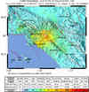
The largest acceleration was about 44% g at Walnut, about 11 km northwest of the epicenter; the peak velocity was 38 cm/sec and the duration was a few seconds. Most observations in the greater Los Angeles area were in the 10% g to 20% g acceleration range, from Ontario to downtown Los Angeles, and south to Santa Ana. Peak velocities in that area were mostly in the range 5 to 15 cm/sec. There were very few reports of damage. (Source: Center for Engineering Strong Motion Data)
Earthquake Maps

Scientific & Technical Information
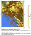
 SCSN Moment Tensor Solution
- USGS Centroid Moment Tensor Solution
- Global CMT Project Moment Tensor Solution
- USGS Body-Wave Moment Tensor Solution
- Historic Moment Tensor Solutions
- Theoretical P-Wave Travel Times
- Waveforms
- Energy and Broadband Solution
- Strong-motion records from Center for Engineering Strong Motion Data (CESMD)
