 |
  |
Metropolitan and Micropolitan Statistical Areas Wall Maps
November 2004
|
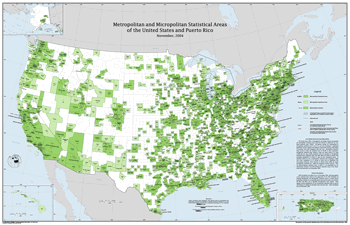
Metropolitan and Micropolitan Statistical Areas of the United States and Puerto Rico, November 2004
The "Metropolitan and Micropolitan Statistical Areas of the United States and Puerto Rico" wall map shows metropolitan and micropolitan statistical areas, metropolitan divisions, and their component counties.
|
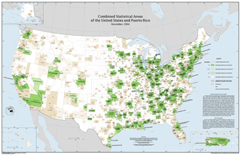
Combined Statistical Areas of the United States and Puerto Rico, November 2004
The "Combined Statistical Areas of the United States and Puerto Rico" wall map shows combined statistical areas, and identifies their component metropolitan, and micropolitan statistical areas. Metropolitan and micropolitan statistical areas which fall outside of combined statistical areas are also identified. However, the component counties of metropolitan and mircropolitan statistical areas are not identified.
| ||
|
|
| ||
Downloading InstructionsThe PDF files for each map are quite large and opening them within your browser is not recommended. Instead, right-click on the PDF links and choose the "save target as" option in Internet Explorer, or "save link as" option in Netscape Navigator. Once the files are downloaded to your computer they can easily be viewed with Adobe® Reader®, which can be downloaded for free from the Adobe® website. How to Order Printed MapsTo obtain a printed version of these maps, please contact the Census Bureau's Geography Division at 301-763-1128 and specify that you would like the November 2004 version. The printed versions measure 55.5 by 36 inches. The maps cost $18.00 each. Prices are for orders shipped within the United States. International orders will cost slightly more. |