|
 |
|
Maps & Photos
Tanks
Date: April 14, 2003
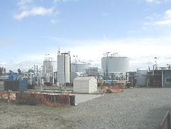
View of the groundwater treatment plant and decontamination pad from the site facing east | 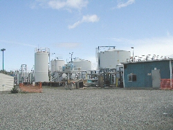
Groundwater Treatment Plant |

Equalization Tanks and Effluent Tank on Eastern Side of Treatment Pad | 
Aeration Basin |
Let there be steam
Date: September 23, 2002

Steam is shown vented to the atmosphere through the end of the main steam line in the pilot area. The steam was later injected into the ground. | 
Another view of steam venting to atmosphere |
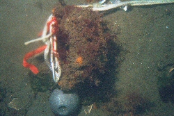
Underwater Photos
Photographer: EPA Dive Team
Date: August 2002
Close-up view of outfall pipe; the freshwater coming out of the pipe appears hazy | 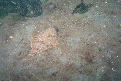
Bottom fish typical of area |

Carefully scooping sediment into jar | 
Sediment sampling (opening jar) |
Historical Photos
Photographer: Curtis, Asahel, 1874-1941
Collection: Asahel Curtis Photo Company Collection no. 482
Contributor: University of Washington Libraries. Manuscripts, Special Collections, University Archives Division
Repository: University of Washington Libraries. Manuscripts, Special Collections, University Archives Division
Date: 1909

Exterior view of Pacific Creosoting Co., Eagle Harbor, Bainbridge Island, WA | 
Section of 2-part panorama 16219,16220. Pacific Creosoting Co., Eagle Harbor, Bainbridge Island, WA | 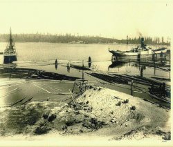
Section of 2-part panorama 16219,16220. Pacific Creosoting Co., Eagle Harbor, Bainbridge Island, WA |

Section of 2-part panorama 16217,16218. Pacific Creosoting Co., Eagle Harbor, Bainbridge Island, WA | 
Section of 2-part panorama 16217,16218. Pacific Creosoting Co., Eagle Harbor, Bainbridge Island, WA | 
Worker's cottages of Pacific Creosoting Co., Eagle Harbor, Bainbridge Island, WA |
Sheet Pile Wall Installation at Wyckoff
Date: January 2000

Long sheets of metal called "sheet pile" were driven into the ground along the shoreline of the contaminated Wyckoff property to form a barrier preventing contamination from seeping off site. Sheet piles ranged in length from 40 feet to over 100 feet. | 
Sheet pile were driven using a "vibratory" hammer pictured here. The vibratory hammer grips each pile from the top and vibrates it, loosening the soil beneath, allowing the pile to drop into place. | 
The sheet pile wall was installed just offshore in the beach. The gap between the sheet pile wall and the upland was filled with clean material excavated from the habitat site on the western portion of the site. |

View of sheet pile installation along the eastern shoreline of the site | 
In addition to installing sheet pile along the shoreline, approximately 500 feet of sheet pile was installed upland in preparation for a pilot test of thermal treatment. The pilot wall will provide valuable information both during and after the pilot test which will help determine the effectiveness of thermal treatment at the site. | 
View of newly excavated habitat beach from Eagle Harbor. |
Mitigation Beach Consturction and Bulkhead Removal
Date: 2001
A beach habitat area was created by removing an old bulkhead and contouring back the slope. Over 1200 feet of new beach was created.

The bulkhead was removed on the south side of Eagle Harbor and to the west of the former Wyckoff site | 
Another view of the former bulkhead | 
Removal of contaminated beach material |
Removed beach material was separated as clean or contaminated. Clean material was removed and placed as backfill behind the sheetpile wall. Contaminated material was stockpiled on the contaminated portion of the site for future treatment. | 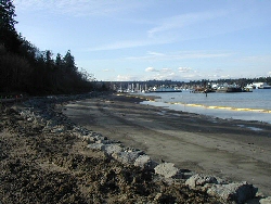
Completed mitigation beach |  |
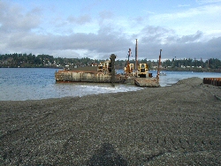
Sediment Cap Extension
Date: 2001-2002
In 2001 EPA completed a 15-acre sediment cap extending from the southern boundary of the earlier cap to the Wyckoff property. The cap is about 3 feet thick. In late 2001 and early 2002, more clean material was placed extending out several hundred feet from the Wyckoff property to form a gently sloping beach which connects the habitat beach to the west with existing intertidal areas to the east.
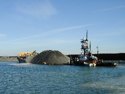
Barge brings cap material to shore | 
Sluicing of cap material from barge | 
Movement of materials from barge |
Unloading material into harbor | 
A conveyor belt system was used to deposit material into the harbor | 
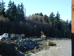
Former Log Storage/Peeler Area |
Former Log Storage/Peeler Area Cleanup
Date: 200-2002
EPA completed cleanup of the western portion of the site, known as the former Log Storage/Peeler Area. About 30,000 cubic yards of contaminated soil were removed and consolidated within the former process area for later cleanup. Excavated areas were backfilled with clean soil.

Contaminated soil removal in Former Log Storage/ Peeler Area | 
Another view of contaminated soil removal in Former Log Storage/ Peeler Area | 
Contaminated soil removal in Former Log Storage/ Peeler Area south of Mitigation Beach area |
Habitat Beach Planting
Date: November 2001
EPA and other volunteers planted over 2,000 native trees, plants, shrubs, and grass in the habitat beach area.

Work crew poses in the mitigation beach area | 
View of vegetation plantings in habitat beach area | 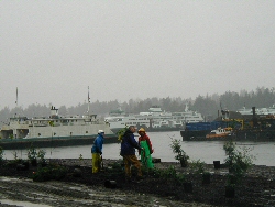
Coordination of plantings in habitat beach area |
Installation of Pilot Study Thermal Monitoring Devices
Date: 2001
EPA installed 16 injection wells and seven extraction wells in the steam injection pilot area, as well as over 500 thermal monitoring devices.

A drilling rig was located onsite was used for drilling bore holes in preparation of well and thermal device installations | 
Geoprobes were used to install the thermal monitoring devices | 
The field crew prepares the thermal monitoring device for installation |
East Beach Sample Collection
Date: Several times during and after placement of sediment cap in 2001

East Beach area | 
Geoprobe sample collection on East Beach | 
Field crew access to the East Beach area |

Seeps of product emerge from the sand in the East Beach area | 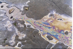
Sheen observed on East Beach | 
Footprints shown on oily sand in East Beach area |
[ Main Cleanup | Brownfields ]
[ Superfund | FOIA | Records Center ]
Point of contact: Jeanne O'dell
E-Mail: odell.jeanne@epa.gov
Phone Number: (206) 553-6919
Last Updated: 05/26/2006
|