
USGS CoreCast
USGS Podcasts Home > CoreCast Home Page
Can't see Flash? Install Flash Player.
|
29
|
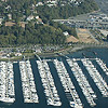
Rick Dinicola, hydrologist with the Coastal Habitats in Puget Sound (CHIPS) program, tells about the effects of urbanization in Puget Sound, Wash.—disappearing habitats, increasing contaminants, and declining fish and wildlife populations.
Type: audio/mpeg
File Size: 11927884 bytes Duration: 12:20 Released: Thu, 14 Feb 2008 11:47:21 UTC |
Transcript:
Advertisement (CoreFacts):
This episode of CoreCast is brought to you by the following sponsor.
###
[Voices: Girlfriend-Jenn LaVista; Boyfriend/Narrator-Scott Horvath]
Girlfriend
Awww, a Valentine's card from my honey!
[paper tearing/rustling effect, sappy music starts]
Girlfriend
[clears throat] "My dearest darling..." [fades out]
Boyfriend
[fades in as girlfriend fades out]
My dearest darling, how I have sat pondering ways to express my love for you. [Girlfriend sighs.]
Perhaps I could prepare you a romantic dinner by candlelight [Girlfriend: Oooh!], whisk you away on a magical journey [Girlfriend: Yeah!], or offer something small, sparkling, and beautiful to adorn your hand. [Girlfriend: All right!]
But no, none of these would be enough for the woman I love, so I instead offer you this knowledge: About 193,000 metric tons of gold have been discovered on Earth so far, and 62 percent of that is found in just four countries. And all the gold discovered thus far would fit in a cube 22 meters on a side. [Girlfriend: What?]
Let this knowledge and that gold cube linger in your mind as the gifted pledge of my love for you.
Girlfriend
Ugh...what a cheapskate!
Boyfriend/Narrator
This Valentine's Day, let natural science wisdom be your expression...of affection. Subscribe to CoreFacts, the quick, weekday science Q & A from the U-S-G-S.
CoreFacts: It's short on time, and big on science.
Girlfriend
Unbelievable.
Music credit: "Fairies", warg
###
[music fades in and out]
[sound of water lapping the shoreline of Puget Sound: in, then under and fade]
John Clemens
Hello, and welcome to the U-S-G-S CoreCast. I'm John Clemens.
Puget Sound is the large inland waterway of the Pacific Northwest. It's an icon. It's the second-largest estuary in the United States...and it's in trouble. The health of Puget Sound is declining—habitats are disappearing, contaminants are flowing in, and species are having a tough time. To help restore and preserve Puget Sound, scientists from the U-S-G-S are studying the nearshore, the place where human influences meet the creatures of Puget Sound.
Today, we'll hear from Rick Dinicola, a hydrologist and one of the three task leaders of the U-S-G-S Coastal Habitats in Puget Sound...or CHIPS, for short. I interviewed Rick at his office in the U-S-G-S Washington Water Science Center in Tacoma....
John:
Talk a bit about CHIPS...first, CHIPS...Coastal Habitats In Puget Sound....
Rick Dinicola
Coastal Habitats In Puget Sound. This is one of the first or earlier interdisciplinary projects started in the U-S-G-S out here on the West Coast. And by interdisciplinary, we mean that scientists from all four of our disciplines contribute there, rather than doing parallel research in the same study area. We truly get together and work on issues and data collection strategies that include all the scientists' expertise.
Puget Sound seemed like a good place to start. There are some issues that involve water, biology, geography, and certainly coastal and marine geology. We had a number of people doing a little bit of work on each in the basin, so we thought we'd come together and see how well we could all work together on some of the larger-scale issues in the Sound.
John
What's your project?
Rick
My project, in particular? I'm the task leader for one of three projects under CHIPS. As you mentioned, CHIPS is Coastal Habitats In Puget Sound. The purpose of the project I'm working on is to look at the effects of urbanization on nearshore habitats and nearshore ecology in Puget Sound. The CHIPS program, in general, falls under a larger umbrella of the Puget Sound Nearshore Restoration Project, led by the U-S Army Corps of Engineers. There are a number of people working to support large-scale restoration activities in Puget Sound. So, our work is some of the science that is needed to support such restoration activities. I lead the task looking the urbanization effects on the nearshore.
John
Why study Puget Sound? It looks okay to most people; when you look at the area, it looks pristine. Why study the Puget Sound?
Rick
Well, there are a number of indicators. You're right that it does look pristine, and that's one of the best reasons to study it now. In a nutshell, there are a number of people around the state who recognize that Puget Sound looks very healthy right now, but there are a number of warning signs about the health of Puget Sound, from relatively high levels of toxic contaminants in marine mammals and fish, to increased population growth in watersheds that drain to Puget Sound, to increased number of species on the endangered-species list.
I guess, in a nutshell, as we look around at the major, large estuaries around the U-S, we see Chesapeake Bay has a lot of problems, down in the Everglades there are a lot of problems, in San Francisco Bay there are a lot of problems. Essentially, we would like to understand and protect Puget Sound before it gets that bad. The restoration work going on in those three sites I mentioned are massive undertakings with a great deal of uncertainty as to whether they could really bring those ecosystems back to being productive and healthy like they once were. We recognize that there are a number of things that could be done now in Puget Sound to keep it from getting to that state.
John
So, how do you study the effects of urbanization? What is the yardstick for that kind of thing? How do you measure that, and what kinds of things do you study in order to figure out what those effects are?
Rick
Well, as you can imagine, most anything we might do in building subdivisions and cities and whatnot will eventually affect the environment, in one way or another. Some ways are relatively minor, and other ways are more important. So, we start out by making scientists refer to as our conceptual models, and we sit down and draw diagrams with arrows and boxes and thinking of all the different ways that urbanization-the process of moving in and building cities and towns and roads-can ultimately affect the nearshore ecosystem, both the fish and the chemistry coming in and the amount of freshwater coming in, and the timing of the freshwater.
Then we start looking at the data that we have in our hands to tell use which ones are really important, which ones are perhaps less important. What we came down to in our project, our most simplified conceptual model, is that there are two ways that urbanization can really affect the nearshore. One of them is what comes out of our rivers and streams; some of that is the amount of water and sediment comes out of our rivers and streams. The changes that results from that are relatively minor, but effects from the types and the amounts of chemicals that come out of our urbanized versus our non-urbanized watersheds is quite different. We have lots of information on what to expect in freshwater streams that come out of watersheds. We have less information on what happens when that goes into Puget Sound and gets greatly diluted by all that seawater.
But there is a relatively narrow strip of land along the shore where the concentrations of those chemicals may be high enough to have causes and effects. So, that's one thing that we looked at: what comes out of our watersheds. The second part of urbanization is the actual building of homes and structures right immediately along the shoreline. That includes both the armoring of the shoreline for protection from erosion, removal of the vegetation that provides shade and cover for the organisms that live in the shallow water, and a whole host of changes that go along with building homes and communities immediately along the shore.
We have two different types of urbanization that we chose to look at here. That strip of land is what we call the "nearshore," and there a few different definitions for it. Basically, it goes up to the top of the beach, the high-tide mark, or even slightly above. We include the beach itself that stays above water and the shoreline bluffs as part of the nearshore environment. It goes down to a depth where light can still penetrate. And that's important, because when light can penetrate, you get vegetation growth growing underneath there, which is important to a lot of the aquatic species. The nearshore is very important for a lot of critical species in Puget Sound, particularly for what we call forage fish. These are the small fish that aren't quite at the bottom of the food but are relatively low on the food chain that provide the primary source of food for larger fish, marine organisms, and marine birds in Puget Sound region.
The most extensive forage fish species in Puget Sound require a healthy nearshore to reproduce; that is where they spawn. The herring, which is the most abundant forage fish in Puget Sound, prefer to spawn on a plant called eelgrass that grows below the average low-tide level but within the nearshore. The other two relatively abundant species, sand lance and surf smelt, actually spawn, or lay their eggs, high up on beaches during high tides. Those eggs will hatch during a subsequent high tide a few weeks later. Those are examples of what we call "obligate use." These species absolutely require a healthy nearshore to reproduce. There are plenty of other species that use the nearshore, such as juvenile salmon. They prefer to stay in shallow water and actually hide in shallow water while they're young and growing up, so that they don't get eaten by larger fish, the predators. Most of our shellfish live in and reproduce, and are harvested from the nearshore environment. There's a whole, essentially hidden, lower part of the food chain that supports all of these organisms, and that require a clean and healthy nearshore environment to be healthy.
John
Okay, Rick, thank you very much.
Rick
Okay, thank you, John.
John
I appreciate it.
And thanks to all of you for listening to this episode of CoreCast. You can find out more about the U-S-G-S Coastal Habitats In Puget Sound program at puget-dot-U-S-G-S-dot-gov.
CoreCast is a product of the U-S Geological Survey, Department of the Interior. Until next time, I'm John Clemens...thanks for listening.
[music fades in and out]
Mentioned in this episode:
Music credit:
"100 BPM-Bassline A.mp3", frifrafro

