 |
|
|
||||
| Earth Resources Observation and Science (EROS) |
Shuttle Radar Topography Mission (SRTM) - "Finished"
| Contents: | 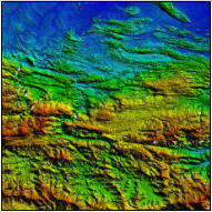 SRTM subset image |
|
back to Elevation Product List Product Description:The Shuttle Radar Topography Misssion (SRTM) is a partnership between NASA and the National Geospatial-Intelligence Agency (NGA). Flown aboard the NASA Space Shuttle Endeavour (11-22 February 2000), SRTM fulfilled its mission to map the world in three dimensions. The USGS is under agreement with NGA and NASAs Jet Propulsion Laboratory to distribute the data. SRTM utilized dual Spaceborne Imaging Radar (SIR-C) and dual X-band Synthetic Aperture Radar (X-SAR) configured as a baseline interferometer to successfully collect data over 80 per cent of the Earth's land surface, everything between 60 degrees North and 56 degrees South latitude. SRTM data is being used to generate a digital topographic map of the Earth's land surface with data points spaced every 1 arc second for the United States of latitude and longitude (approximately 30 meters). The SRTM "finished" data meet the absolute horizontal and vertical accuracies of 20 meters (circular error at 90% confidence) and 16 meters (linear error at 90% confidence), respectively, as specified for the mission. Back to TopProcess:SRTM data were processed from raw radar echoes into digital elevation models at the Jet Propulsion Laboratory (JPL) in Pasadena, CA. These original data files had samples spaced ("posted") at intervals of 1 arc-second of latitude and longitude (about 30 meters at the equator). These data were then edited by the National Geospatial Intelligence Agency (NGA, formerly the National Imagery and Mapping Agency), and distributed as part of their DTED® product set. The editing, also referred to as finishing, consisted of delineating and flattening water bodies, better defining coastlines, removing "spikes" and "wells", and filling small voids. This "finished" set is publicly available at two postings: 1 arc-second for the United States and its territories and possessions, and 3 arc-seconds for regions between 60 degrees North and 56 degrees South latitude. Back to TopAvailable Products:
SRTM data at 1 arc second (30 meter) is currently available for the United States, its territories and possessions. SRTM data at 3 arc-second (90 meters) is currently available for global coverage between 60 degrees North and 56 degrees South latitude. The product consists of seamless raster data. Instantaneous download is available for areas up to 30 square degrees latitude/longitude (in 100 mb files). The data is expressed in geographic coordinates (latitude/longitude) and is horizontally and vertically referenced to the EGM96 Geoid. The "finished" data is available in four formats: The 1 arc second (30 meter) data for the United States its territories and possesions and the 3 arc second (90 meter) data for global coverage between 60 degrees North and 56 degrees South latitude is distributed by the National Center for Earth Resources Observation & Science (EROS) on DVD. Each DVD consists of a grid area with 1 x 1 degree cells. The cell is labeled as the southwest corner. The data is derived from "Finished" data supplied by NGA. The "finished" data is available as SRTM format. The SRTM format is created from the SRTM DTED® and each cell will consist of 5 files: .bil .blw .hdr .prj .stx The data is a simple binary raster format (signed integer data, 16 bit). There is an accompanying ASCII header file that provides file size information (number of rows and columns). The data are stored in row major order (all the data for row 1, followed by all the data for row 2, etc.). Additional Information: SRTM EROS HomepageGISDATA Web mapping Portal SRTM NASA/JPL Homepage National Geospatial-Intelligence Agency (NGA) 
Back to TopPrices
Back to TopSearch & Order
|
| Accessibility FOIA Privacy Policies and Notices | |
 |
|