USGS - science for a changing world

Natural Hazards

Maps, Imagery, and Publications Hazards Newsroom Education Jobs Partnerships Library About USGS Podcasts/RSS

USGS Science: Before, During and After the Storm

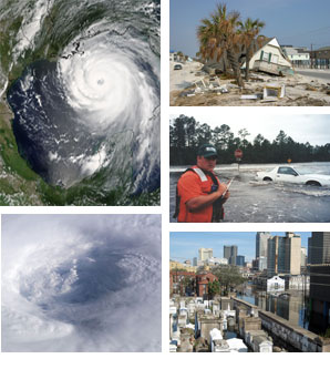
Millions of Americans live in coastal areas, especially in the Atlantic and Gulf coasts, that may be in the direct path of hurricanes this season.

Hurricanes bring destructive winds, storm surge, torrential rain, flooding, and tornadoes. A single storm can wreak havoc on coastal and inland communities on natural areas over thousands of square miles. Recent Atlantic hurricane seasons have been the costliest on record, with losses of $42 billion in 2004 and in the hundreds of billions in 2005.

A major goal of the U.S. Geological Survey is to reduce the vulnerability of the people and areas most at risk from natural hazards. Working with partners throughout all sectors of society, the USGS has initiated specific actions to prepare for the impending hurricane season. Improved monitoring of conditions on the ground from flooding and storm surge, enhanced ability to navigate in a disaster zone, and better assessments of the effect on coastlines and ecology are just a few of the benefits anticipated from these actions.

The USGS provides information, products and knowledge to help build more resilient communities, and strives to keep America safe from natural hazards.

Mark Myers
Director, USGS

collage of hurricane pictures:  scientist taking water samples, rescue operations, and command station.
Upper left - Category-4 Hurricane Katrina moving towards the coasts of Louisiana, Mississippi, and Alabama on August 28, 2005. (photo credit: NASA Terra Satellite)
Lower left - The eye of Hurricane Isabel as seen from the International Space Station on September 13, 2003 (photo credit: NASA)
Upper right - The remains of this home were washed across the road by waves during Hurricane Ivan. Only the roof and upper floor remains
Middle right - Road Overflow, 09/29/1998 Water flowing over State Highways 15 & 16 near their intersection during September 1998 Flood on Tchoutacabouffa River caused by Hurricane Georges
Lower right - New Orleans, LA, flooding from Hurricane Katrina

USGS Has Science That Weathers the Storm

The USGS conducts a wide variety of research and monitoring activities before, during and after the storm including:  geospatial information which is crucial for search and rescue operations, rapid deployment of mobile streamgages, coastal laser mapping, ecological monitoring and wetlands loss.   Learn more

Coastal Impacts
Chandeleur Island, before and after Hurricane Katrina
Satellite Imagery and other Geospatial Data
Image showing New Orleans before and after Hurricane Katrina.
Ecological Impacts
everglades
Monitoring Streamflow Conditions
Image of real-time water data for the Nation
Hurricane Related Podcasts
Image representing CoreCast.
News Releases
Image representing a news release.
Publications
Photo showing many books in a pile.

NOAA: National Hurricane Center (Atlantic)

  • Atlantic Tropical Weather Outlook
    000 ABNT20 KNHC 170551 TWOAT TROPICAL WEATHER OUTLOOK NWS TPC/NATIONAL HURRICANE CENTER MIAMI FL 200 AM EDT WED SEP 17 2008 FOR THE NORTH ATLANTIC...CARIBBEAN SEA AND THE GULF OF MEXICO... TROPICAL CYCLONE FORMATION IS NOT EXPECTED DURING THE NEXT 48 HOURS. $$ FORECASTER PASCH

  • There are no tropical cyclones at this time.
    No tropical cyclones as of Wed, 17 Sep 2008 06:08:10 GMT


NOAA: National Hurricane Center (East Pacific)

  • East Pacific Tropical Weather Outlook
    000 ABPZ20 KNHC 170550 TWOEP TROPICAL WEATHER OUTLOOK NWS TPC/NATIONAL HURRICANE CENTER MIAMI FL 1100 PM PDT TUE SEP 16 2008 FOR THE EASTERN NORTH PACIFIC...EAST OF 140 DEGREES WEST LONGITUDE.. TROPICAL CYCLONE FORMATION IS NOT EXPECTED DURING THE NEXT 48 HOURS. $$ FORECASTER PASCH

  • There are no tropical cyclones at this time.
    No tropical cyclones as of Wed, 17 Sep 2008 06:08:10 GMT


Additional Hurricane Resources


USGS Storm Team (password required)

Accessibility FOIA Privacy Policies and Notices

Take Pride in America logo USA.gov logo U.S. Department of the Interior | U.S. Geological Survey
URL: http://www.usgs.gov/hazards/hurricanes/2008/default.asp
Page Contact Information: Ask USGS
Page Last Modified: Monday, September 15, 2008