|
Water Surfaces
Download Data
 Data is available in two different formats, in addition to metadata information: Data is available in two different formats, in addition to metadata information:
We are also providing the daily median output files, which are in turn used as input files for creation of the surface layers. These files show which stations were or were not used for a given day's surface creation.
NetCDF Files:
NetCDF (Network Common Data Form) is a set of freely-distributed software libraries and machine-independent binary data formats that support the creation, access, and sharing of large array-oriented scientific data. This format replaces the bulky file structure and difficult file management of ESRI GRIDS for EDEN data. It also allows EDEN applications to run on computers without ArcGIS installations.
Each file contains 3 months (one quarter-year) of daily datasets. So, for example, the data for every day in 2002 will be stored in 4 files: 2002_q1.nc, 2002_q2.nc, 2002_q3.nc, and 2002_q4.nc. In addition, each zip file contains a readme file which contains brief information about release notes related to this data release.
| NetCDF Files
(File naming conventions: "prov"=provisional, "v1"= version 1 of surface water model
"r1"= first release of surfaces, "r2"=second release of surfaces; note: if no "r" notation is given, then it is the first release of that surface)
|
| Date |
1/1 - 3/31 |
4/1 - 6/30 |
7/1 - 9/30 |
10/1 - 12/31 |
| 2000 |
2000 Q1 (zip, 16 MB)
release 1, Oct. 2007 |
2000 Q2 (zip, 16 MB)
release 2, March 2008 |
2000 Q3 (zip, 16 MB)
release 2, March 2008 |
2000 Q4 (zip, 16 MB)
release 2, March 2008 |
| 2001 |
2001 Q1 (zip, 16 MB)
release 2, March 2008 |
2001 Q2 (zip, 16 MB)
release 2, March 2008 |
2001 Q3 (zip, 16 MB)
release 2, March 2008 |
2001 Q4 (zip, 16 MB)
release 2, March 2008 |
| 2002 |
2002 Q1 (zip, 16 MB)
release 2, March 2008 |
2002 Q2 (zip, 16 MB)
release 2, March 2008 |
2002 Q3 (zip, 16 MB)
release 2, March 2008 |
2002 Q4 (zip, 16 MB)
release 1, Oct. 2007 |
| 2003 |
2003 Q1 (zip, 16 MB)
release 1, Oct. 2007 |
2003 Q2 (zip, 16 MB)
release 1, Oct. 2007 |
2003 Q3 (zip, 16 MB)
release 1, Oct. 2007 |
2003 Q4 (zip, 16 MB)
release 2, March 2008 |
| 2004 |
2004 Q1 (zip, 16 MB)
release 2, March 2008 |
2004 Q2 (zip, 16 MB)
release 2, March 2008 |
2004 Q3 (zip, 16 MB)
release 2, March 2008 |
2004 Q4 (zip, 16 MB)
release 2, March 2008 |
| 2005 |
2005 Q1 (zip, 16 MB)
release 2, March 2008 |
2005 Q2 (zip, 16 MB)
release 2, March 2008 |
2005 Q3 (zip, 16 MB)
release 2, March 2008 |
2005 Q4 (zip, 16 MB)
release 1, Feb. 2008 |
| 2006 |
2006 Q1 (zip, 16 MB)
release 1, Feb. 2008 |
2006 Q2 (zip, 16 MB)
release 1, Feb. 2008 |
2006 Q3 (zip, 16 MB)
release 1, Feb. 2008 |
2006 Q4 (zip, 16 MB)
release 1, Sept. 2008 |
| 2007 |
2007 Q1 (zip, 16 MB)
release 1, Sept. 2008 |
2007 Q2 (zip, 16 MB)
release 1, Sept. 2008 |
2007 Q3 (zip, 16 MB)
release 1, Sept. 2008 |
2007 Q4 (zip, 16 MB)
PROVISIONAL |
| 2008 |
Real-Time Data |
Real-Time Data |
Real-Time Data |
Real-Time Data |
| Archived NetCDF Files |
| Additional Documentation for EDEN NetCDF Files:
|
|
GeoTiff
Each zip file contains 3 months (one quarter-year) of georeferenced tiff files. For each day, there are two files: a .tif and a .aux file. Both are needed in order to view the file properly.
| GeoTiff Files
(File naming conventions: "prov"=provisional, "v1"= version 1 of surface water model
"r1"= first release of surfaces, "r2"=second release of surfaces; note: if no "r" notation is given, then it is the first release of that surface)
|
| Date |
1/1 - 3/31 |
4/1 - 6/30 |
7/1 - 9/30 |
10/1 - 12/31 |
| 2000 |
2000 Q1 (zip, 55 MB)
release 1, Oct. 2007 |
2000 Q2 (zip, 56 MB)
release 2, March 2008 |
2000 Q3 (zip, 55 MB)
release 2, March 2008 |
2000 Q4 (zip, 55 MB)
release 2, March 2008 |
| 2001 |
2001 Q1 (zip, 55 MB)
release 2, March 2008 |
2001 Q2 (zip, 56 MB)
release 2, March 2008 |
2001 Q3 (zip, 55 MB)
release 2, March 2008 |
2001 Q4 (zip, 55 MB)
release 2, March 2008 |
| 2002 |
2002 Q1 (zip, 55 MB)
release 2, March 2008 |
2002 Q2 (zip, 56 MB)
release 2, March 2008 |
2002 Q3 (zip, 55 MB)
release 2, March 2008 |
2002 Q4 (zip, 55 MB)
release 1, Oct. 2007 |
| 2003 |
2003 Q1 (zip, 55 MB)
release 1, Oct. 2007 |
2003 Q2 (zip, 55 MB)
release 1, Oct. 2007 |
2003 Q3 (zip, 55 MB)
release 1, Oct. 2007 |
2003 Q4 (zip, 55 MB)
release 2, March 2008 |
| 2004 |
2004 Q1 (zip, 55 MB)
release 2, March 2008 |
2004 Q2 (zip, 55 MB)
release 2, March 2008 |
2004 Q3 (zip, 55 MB)
release 2, March 2008 |
2004 Q4 (zip, 55 MB)
release 2, March 2008 |
| 2005 |
2005 Q1 (zip, 55 MB)
release 2, March 2008 |
2005 Q2 (zip, 58 MB)
release 2, March 2008 |
2005 Q3 (zip, 55 MB)
release 2, March 2008 |
2005 Q4 (zip, 55 MB)
release 1, Feb. 2008 |
| 2006 |
2006 Q1 (zip, 55 MB)
release 1, Feb. 2008 |
2006 Q2 (zip, 56 MB)
release 1, Feb. 2008 |
2006 Q3 (zip, 55 MB)
release 1, Feb. 2008 |
2006 Q4 (zip, 56 MB)
release 1, Sept. 2008 |
| 2007 |
2007 Q1 (zip, 55 MB)
release 1, Sept. 2008 |
2007 Q2 (zip, 56 MB)
release 1, Sept. 2008 |
2007 Q3 (zip, 58 MB)
release 1, Sept. 2008 |
2007 Q4 (zip, 56 MB)
PROVISIONAL |
| 2008 |
Real-Time Data |
Real-Time Data |
Real-Time Data |
|
| Archived GeoTiff Files |
|
|
|
Daily Median Output Files
Each zip file contains 3 months (one quarter-year) of daily datasets. There are two files for each day: a "median" and a "median_reject". The "median" file is the one that was used to create the surfaces for a given day; the "median_reject" file contains a list of the gages not used for that day. A readme file is included with each zip file that includes a short description of each file.
| Daily Median Output Files
(File naming conventions: "prov"=provisional, "v1"= version 1 of surface water model
"r1"= first release of surfaces, "r2"=second release of surfaces; note: if no "r" notation is given, then it is the first release of that surface)
|
| Date |
1/1 - 3/31 |
4/1 - 6/30 |
7/1 - 9/30 |
10/1 - 12/31 |
| 2000 |
2000 Q1 (zip, .5 MB)
release 1, Oct. 2007 |
2000 Q2 (zip, .5 MB)
release 2, March 2008 |
2000 Q3 (zip, .5 MB)
release 2, March 2008 |
2000 Q4 (zip, .5 MB)
release 2, March 2008 |
| 2001 |
2001 Q1 (zip, .5 MB)
release 2, March 2008 |
2001 Q2 (zip, .5 MB)
release 2, March 2008 |
2001 Q3 (zip, .5 MB)
release 2, March 2008 |
2001 Q4 (zip, .5 MB)
release 2, March 2008 |
| 2002 |
2002 Q1 (zip, .5 MB)
release 2, March 2008 |
2002 Q2 (zip, .5 MB)
release 2, March 2008 |
2002 Q3 (zip, .5 MB)
release 2, March 2008 |
2002 Q4 (zip, .5 MB)
release 1, Oct. 2007 |
| 2003 |
2003 Q1 (zip, .5 MB)
release 1, Oct. 2007 |
2003 Q2 (zip, .5 MB)
release 1, Oct. 2007 |
2003 Q3 (zip, .5 MB)
release 1, Oct. 2007 |
2003 Q4 (zip, .5 MB)
release 2, March 2008 |
| 2004 |
2004 Q1 (zip, .5 MB)
release 2, March 2008 |
2004 Q2 (zip, .5 MB)
release 2, March 2008 |
2004 Q3 (zip, .5 MB)
release 2, March 2008 |
2004 Q4 (zip, .5 MB)
release 2, March 2008 |
| 2005 |
2005 Q1 (zip, .5 MB)
release 2, March 2008 |
2005 Q2 (zip, .5 MB)
release 2, March 2008 |
2005 Q3 (zip, .5 MB)
release 2, March 2008 |
2005 Q4 (zip, .5 MB)
release 1, Feb. 2008 |
| 2006 |
2006 Q1 (zip, .5 MB)
release 1, Feb. 2008 |
2006 Q2 (zip, .5 MB)
release 1, Feb. 2008 |
2006 Q3 (zip, .5 MB)
release 1, Feb. 2008 |
2006 Q4 (zip, .5 MB)
release 1, Sept. 2008 |
| 2007 |
2007 Q1 (zip, .5 MB)
release 1, Sept. 2008 |
2007 Q2 (zip, .5 MB)
release 1, Sept. 2008 |
2007 Q3 (zip, .5 MB)
release 1, Sept. 2008 |
2007 Q4 (zip, .5 MB)
PROVISIONAL |
| 2008 |
Real-Time Data |
Real-Time Data |
Real-Time Data |
|
| Archived Daily Median Output Files |
| Additional Documentation for Daily Median Output Files:
|
|
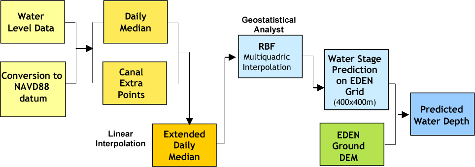
How Are Water Surfaces Created?
The water surface model follows the steps illustrated below:
- Water-level data for all the EDEN gages is retrieved from an ftp server.
- Water-level data reported in NGVD 29 are converted to NAVD 88
- Daily median water level is calculated.
- Linear interpolation is used to create boundary conditions along canals and levees.
- Radial Basis Function multiquadric interpolation of extended data (median water level from gages in marsh and interpolated values along canals) is used to generate continuous water level surfaces daily.
- The continuous water surface is predicted on the EDEN grid (400 m x 400 m).
- Water depth is estimated by subtracting the EDEN ground digital elevation model (DEM) from the predicted water surface.
The USGS retrieves water level data daily from 253 gaging stations including 225 telemetry-enhanced gages that record and transmit several water level values throughout the day, mostly hourly from recorders ranging approximately from 81°07’19W to 80°13’05W in easting and 25°13’27N to 26°40’47N in northing in south Florida. An additional 28 gages do not have telemetry and are manually read and added to the network. All transmitted data are entered and stored in the National Water Information System (NWIS), a database operated by the United States Geological Survey (USGS). There are a total of 240 gages used for water surface interpolation of the freshwater Everglades.
All gages in the EDEN network are operated and maintained by four separate agencies including Everglades National Park (ENP), South Florida Water Management District (SFWMD), Big Cypress National Preserve (BCNP), and the USGS. The NWIS database transmits all recorded data to a local USGS FTP server where it is available for surfacing.
(Text and graphic from "Spatially Continuous Interpolation of Water Stage and Water Depths Using the Everglades Depth Estimation Network (EDEN), University of Florida, IFAS,CIR1521.)
|
|
|