Caribbean Water Science Center Science Plan 1999
Water Resources in Coastal Areas
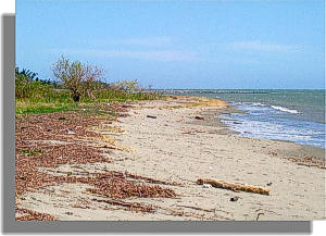 The most important aquifers in Puerto Rico and the U.S. Virgin Islands are in coastal areas. These aquifers have been negatively impacted since the early part of this century by large scale agricultural land reclamation and malaria control projects through construction of drainage and dewatering works. This has led to widespread saline-water encroachment from the coast and thinning of the freshwater lens. Within the past 30 years, this problem have been exacerbated by aquifer overdraft and increased withdrawals of water from streams which has altered the hydrodynamic equilibrium of the saline-water wedge. The most important aquifers in Puerto Rico and the U.S. Virgin Islands are in coastal areas. These aquifers have been negatively impacted since the early part of this century by large scale agricultural land reclamation and malaria control projects through construction of drainage and dewatering works. This has led to widespread saline-water encroachment from the coast and thinning of the freshwater lens. Within the past 30 years, this problem have been exacerbated by aquifer overdraft and increased withdrawals of water from streams which has altered the hydrodynamic equilibrium of the saline-water wedge. Monitoring the location of the saline-freshwater interface with wells and both surface and borehole geophysics has begun. Consequently, the location of the interface has been established in many areas, but its rate of movement cannot be known without long-term monitoring. However, only few synoptic surveys have been conducted to relate stream discharge with the location of the saline-water wedge at estuaries. Monitoring the location of the saline-freshwater interface with wells and both surface and borehole geophysics has begun. Consequently, the location of the interface has been established in many areas, but its rate of movement cannot be known without long-term monitoring. However, only few synoptic surveys have been conducted to relate stream discharge with the location of the saline-water wedge at estuaries.
 Throughout the south coast changes in irrigation practices from furrow irrigation with surface water to micro-irrigation with ground water is seriously depleting the South Coastal Plain aquifer system in Puerto Rico, an important agriculture resource. Sustainable development of this aquifer will require artificial recharge measures to prevent further saline intrusion into the aquifer. Throughout the south coast changes in irrigation practices from furrow irrigation with surface water to micro-irrigation with ground water is seriously depleting the South Coastal Plain aquifer system in Puerto Rico, an important agriculture resource. Sustainable development of this aquifer will require artificial recharge measures to prevent further saline intrusion into the aquifer.
Information Needs and Deficiencies
- The exact vertical position of the saline-freshwater interface needs to be better defined in many areas. The rate of movement of the interface needs to be determined with long-term monitoring.
- The relation of the position of the saline-water in wedge in streams needs to be defined.
- A study is needed to document the changes that have occurred in the south coastal plain aquifer system in Puerto Rico due to the changes in irrigation practices
Program Opportunities
-
Determine the exact vertical position of the saline-freshwater interface in the important aquifers in Puerto Rico. Continue long-term monitoring to determine the rate of movement of the interface in the aquifer. All coastal monitoring wells will be tied to mean sea-level datum.
- Determine the displacement of the saline-water wedge in relation to stream discharge and tides in the island’s major estuaries.
- Determine the areas suitable for artificial recharge to the south coastal plain aquifer system and conduct a pilot study to determine the effect of artificial recharge on the aquifer.
Next: Surface-Water Ground-Water Interactions
|

