Woods Hole Science Center
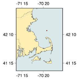
Description: A year-long series of current measurements on the eastern flank of Stellwagen Bank to document the currents at the mouth of Massachusetts Bay driven by the Maine Coastal current. Duration: USGS PIs: R. Signell, B. Butman Publications: Field Activity Reports: 94019, 94040, 94048, 95029 Explore
where measurements were made and the kinds of data
collected during this |
|
Links to the Data |
|
|---|---|
| Basic Sampling Interval | Data access via OPeNDAP |
| Hourly Averaged Data | |

 U.S. Department of the Interior |
U.S. Geological Survey
U.S. Department of the Interior |
U.S. Geological Survey
URL: stellwagen.er.usgs.gov/mbay_stell.html
Page Contact Information: WHSC Webmaster
Page Last Modified: Monday, 24-Mar-2008 11:09:54 EDT