|
||||||
|
|
|||||||
|
||||||||
|
Putting Radon to Work: Identifying Coastal Ground-Water Discharge Sites
When most people think of radon, they think of the naturally occurring, odorless, radioactive gas that can cause health problems when it reaches unsafe levels in basements. The health concerns arise because radon can accumulate in the pore spaces of soil and sediment, and the gas can make its way through cracks and fissures into the basement. For many of the same reasons that radon is a nuisance in basements, radon is also an excellent tracer of ground-water discharge to the coastal ocean. With this application in mind, a team of scientists at the U.S. Geological Survey (USGS) Woods Hole Science Center and the Woods Hole Oceanographic Institution (WHOI) set out to develop a system for mapping radon activity in coastal waters. A similar system has been developed by Professor Bill Burnett of Florida State University.
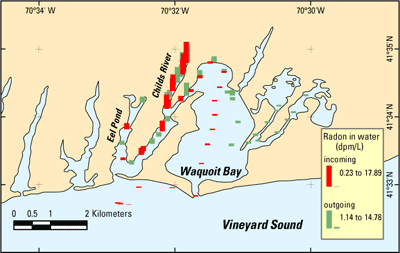
In recent years, it has become increasingly clear that submarine ground-water discharge plays an important role in delivering water and nutrients to coastal waters (see Sound Waves article "Submarine Ground-Water Discharge and Its Influence on Coastal Processes and Ecosystems"). Ground water can play an important role in delivering nutrients because the nutrient concentrations generally are far greater in ground water than in surface waters. Elevated nutrient loads, primarily in the forms of nitrate and ammonium ions, can fuel problematic algal blooms in coastal waters. Identifying the locations of coastal ground-water discharge has proved difficult, however, because the discharge is typically diffuse and below the water surface. New techniques for identifying and quantifying this discharge are clearly needed. In the same way that radon accumulates in soil, it also commonly accumulates in ground water. Radon activity is much lower, by contrast, in seawater. The large difference between ground-water and surface-water activities, together with radon's inert geochemical behavior, makes radon an excellent tracer of ground-water discharge to the coastal ocean. Although techniques for measuring radon activity have existed for many years, these old methods were time consuming and labor intensive. New technology developed in recent years allows rapid, in-place measurement of radon activity (within 30-60 minutes, depending on the activity), permitting data collection at far greater spatial resolution than was previously possible. The first field test of a new system for mapping radon activity in coastal waters as a tracer of submarine ground-water discharge was carried out recently in a set of estuaries surrounding Waquoit Bay near Woods Hole on Cape Cod, MA. Participants in the effort included John Crusius, John Bratton, Dirk Koopmans, Kevin Kroeger, Dann Blackwood, Sarah Kelsey, and VeeAnn Cross from the USGS Woods Hole Science Center, and Matt Charette, Meagan Gonneea, and Ed Hobart from WHOI. This system was developed and tested with financial support from the USGS Geology Discipline's Venture Capital Fund. The new radon-mapping system uses a high-flow bilge pump to transfer seawater to a spray chamber that strips the radon out of the water and into the gas phase. This spray chamber is connected to a series of radon analyzers, each of which measures the radon activity in air from the spray chamber during overlapping time periods. In this way, estimates of the average radon activity can be generated every 5 to 10 minutes. In addition, navigation, depth, salinity, and temperature data are generated at much higher frequency than in earlier mapping systems. All of the data can be monitored from a shipboard computer and recorded, in real time, to a data file, using special software developed for this project. These data can then be mapped by using conventional mapping software. The spatial resolution achieved is limited only by the boat speed and by the equilibration time of approximately 20 minutes required to adjust to new radon activities.
The data from the Waquoit Bay test cruise reveal extremely high radon activities in the Childs River estuary to the west, suggesting considerable discharge of ground water in that region. By contrast, radon activities in the bays immediately east of Waquoit Bay are far lower. Determining the reasons for these differences will require additional study. This radon-mapping system is a valuable new tool for locating sites of ground-water discharge. It complements the electrical-resistivity technique, which identifies fresh ground-water discharge in the subsurface on the basis of the higher electrical resistance of freshwater relative to seawater (see Sound Waves article "Integrated Science Team Deploys New Tools to Study Submarine Ground Water in North Carolina"). Together, these new technologies offer unprecedented sophistication for locating sites of ground-water discharge through rapid regional surveys. Such sites, once pinpointed, can then be studied in greater detail to characterize their geochemistry and to quantify the flux of water and nutrients from ground water at any given coastal location.
|
in this issue:
Coastal Ground Water Discharge Benthic Habitats Near Oil Platforms
Suspended Sediment, Turbidity, and Fish Feeding Behavior USGS Monterey Bay Science Prototype
USGS Biologists Receive DOI Honor Awards
Netherlands Students Assist USGS in Florida
USGS Contributes to New Book About Point Loma |
||||||||||||||||||||||||||||||||