|
|
|
Metadata
|
|
ID
|
00014
|
|
Also Known As
|
00014
MGNM00014
M-14-00-SR
|
|
Abstract
|
United States Geological Survey, Woods Hole, Massachusetts.
Chief Scientists: Bill Schwab, Bob Morton. Data (navigation)
of field activity 00014 (M-14-00-SR) in South Carolina
Central from 03/13/2000 to 03/30/2000
|
|
Organization
|
United States Geological Survey, Woods Hole, Massachusetts
|
|
Project/Theme
|
SC Coastal Erosion
|
|
Chief Scientist
|
Bill Schwab
Bob Morton
|
|
Platform
|
Megan T. Miller
|
|
Owner
|
Miller Marine
|
|
Area of Operation
|
South Carolina Central
|
|
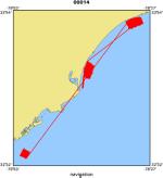
Location map
|
|
|
Bounding Coordinates
|
33.83662
-79.80273 -78.51609
32.59263
|
|
Ports
|
leave Charleston, SC
arrive Charleston, SC
|
|
Dates
|
03/13/2000 (JD 073) to 03/30/2000 (JD 090)
|
|
Days at Sea
|
|
|
Analog Materials
|
No analog holdings.
|
|
Index map

|
|
|
Information Specialist
|
|
|
Crew
|
|
Bill Schwab
|
Chief Scientist, USGS Woods Hole
|
|
Bob Morton
|
Chief Scientist, USGS St. Petersburg
|
|
Bill Danforth
|
Data Processor, USGS Woods Hole
|
|
Tom O'Brien
|
Electronics Technician, USGS Woods Hole
|
|
Chuck Worley
|
Electronics Technician, USGS Woods Hole
|
|
Shawn Dadisman
|
Data Processing, USGS St. Petersburg
|
|
Paul Byham
|
Unspecified, Submetrix Rep.
|
|
|
Equipment Used
|
|
|
Purpose
|
|
Side scan sonar-1000, Submetrix, geopulse, 3.5 khz, fathometer
|
|
|
Notes
|
|
Weather was bad. Limited data collection
|
|
|
Navigation
|
|
|
Project Number
|
|
|
Funding
|
|
|
Publications
|
|
Cruise Report exists at Woods Hole
|
|
|
Got Help?
|
For 00014, we would appreciate any information on -- activity type, analog materials, contract, dive count, information to be derived, national plan, NGDC Info, scanned materials, seismic description, station count, station description, submersible, summary, tabulated info.
|
|