|
|
|
Metadata
|
|
ID
|
88009
|
|
Also Known As
|
88009
NECH88-1-LM
N-1-88-LM
|
|
Abstract
|
United States Geological Survey, Woods Hole, Massachusetts.
Chief Scientists: Dave Folger, Dave Foster. Data (navigation)
of field activity 88009 (N-1-88-LM) in Lake Michigan from
07/25/1988 to 08/13/1988
|
|
Organization
|
United States Geological Survey, Woods Hole, Massachusetts
|
|
Project/Theme
|
Great Lakes
|
|
Chief Scientist
|
Dave Folger
Dave Foster
|
|
Platform
|
Neecho
|
|
Area of Operation
|
Lake Michigan
|
|
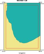
Location map
|
|
|
Bounding Coordinates
|
42.50000
-87.84000 -86.83000
41.50000
|
|
Dates
|
07/25/1988 (JD 207) to 08/13/1988 (JD 226)
|
|
Analog Materials
|
No analog holdings.
|
|
Index map

|
|
|
Crew
|
|
Dave Folger
|
Chief Scientist, USGS Woods Hole
|
|
Dave Foster
|
Chief Scientist, USGS Woods Hole
|
|
Tom O'Brien
|
Unspecified, USGS Woods Hole
|
|
Barry Irwin
|
Unspecified, USGS Woods Hole
|
|
Chris Polloni
|
Unspecified, USGS Woods Hole
|
|
Ken Parolski
|
Unspecified, USGS Woods Hole
|
|
Dave Nichols
|
Unspecified, USGS Woods Hole
|
|
Dave Mason
|
Unspecified, USGS Woods Hole
|
|
T. Tyson
|
Unspecified, USGS Woods Hole
|
|
Dick Tagg
|
USGS Western Region
|
|
|
Equipment Used
|
|
|
Purpose
|
|
|
Got Help?
|
For 88009, we would appreciate any information on -- activity type, analog materials, contract, days at sea, dive count, funding, information specialist, information to be derived, kms of navigation, national plan, NGDC Info, notes, owner, ports, project number, publications, scanned materials, seismic description, station count, station description, submersible, summary, tabulated info.
|
|


