|
|
|
 |
|
Research Project:
A NEW APPROACH TO SEDIMENT TMDL WATERSHEDS IN THE SOUTHERN PIEDMONT
Location: Watershed Physical Processes Research Unit
Project Number: 6408-13000-018-37
Project Type:
Reimbursable
Start Date: Mar 01, 2008
End Date: Feb 28, 2011
Objective:
The overall objective is to develop a new approach for sediment TMDLs in the southern Piedmont. Specific objectives are: (1) Use geomorphic assessments and historic sediment-transport data to determine relative channel stability and target sediment load and yield for the Piedmont eco-region; and (2) Use the AnnAGNPS watershed and CONCEPTS channel evolution computer models to determine potential load reduction scenarios for the North Fork of the Broad River, GA.
Approach:
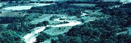
Impairment of southern Piedmont streams is caused by suspended sediments emanating from agricultural sources and streambank erosion from legacy sediment deposited on the floodplain. Location and relative magnitude of these sources need to be known for TMDL implementation plans. Using the North Fork of the Broad River, GA as a case study, a four-tiered approach to sediment TMDLs will be developed in cooperation with the University of Georgia. Robust historical time-series of flow and sediment-transport rates from hydrologically consistent drainage areas will be used to determine the range of annual sediment-transport loadings and target or ¿reference¿ sediment yields for stable streams for the Piedmont eco-region. Sediment fingerprinting, using naturally occurring, stable radio-nuclides and other elements will be used to identify the primary sources of sediment and the relative contribution of legacy sediment and current sources of erosion using a mixing-model approach. Storm samples of suspended sediment will be collected by automatic samplers and analyzed for their concentration of naturally occurring, stable radio-nuclides and other elements to identify the relative contributions from each erosion source. Geomorphic assessments of channel conditions will identify the magnitude and extent of streambank instability. Data on stream channel geometry and streambed and streambank materials will be collected at selected sites to determine the resistance of the channel to erosion. Inputs to the watershed model AnnAGNPS, such as weather, topography, soils, land-use, and land management, will be compiled to describe watershed attributes. These data will be used to validate the AnnAGNPS and CONCEPTS models on observed runoff and sediment loads, and relative contributions from uplands and streambanks. The validated models will then be used to develop various mitigation scenarios for potential sediment load reductions.
|
|
|
|
|
|
Last Modified: 11/08/2008
|
|