
USGS/Cascades Volcano Observatory, Vancouver, Washington
Washington State Volcanoes and Volcanics
Maps and Graphics, etc.
-
 [Interactive Imagemap] ...
[Map,150K,GIF] ...
[Interactive Imagemap] ...
[Map,150K,GIF] ...
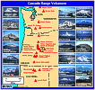
Cascade Range Volcanoes
-- Graphic by: Lyn Topinka, 1996
-
 [Map,20K,InlineGIF]
Major West Coast Volcanoes - Washington, Oregon, and California
-
 [Map,27K,InlineGIF]
Potentially Active Volcanoes of the Western United States
-- Modified from: Brantley, 1994, Volcanoes of the United States:
USGS General Interest Publication
-
 [Graphic,70K,InlineGIF]
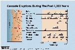
Cascades Eruptions During the Past 4000 Years
-
 [Map,82K,InlineGIF]
Geologic Map of Washington State
-- Topinka, 2002
-
 [Map,18K,InlineGIF]
Washington State and the Columbia River.
-- includes major volcanoes
-- Topinka, 1999
-
 [Map,20K,InlineGIF]
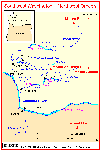
Southwest Washington - Northwest Oregon
-- includes Mounts Rainier, St. Helens, Adams, and Hood
-- Modified from: Doukas, 1990, USGS Bulletin 1859
-
 [Map,35K,InlineGIF]
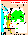
Pacific Northwest Volcanics showing the Cascade Range and
Columbia Plateau
-- Modified from: Swanson et.al., 1989,
American Geophysical Union Field Trip Guidebook T106
-
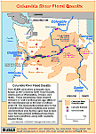 [Map,31K,InlineGIF]
Columbia River Flood Basalts
-- Topinka, 2002
-
 [Map,40K,InlineGIF]
University of Washington's Pacific Northwest Seismic Network
-- Modified from: University of Washington Geophysics Program, 1998,
includes seismic station location map and link to PNSN
-
 [Map,30K,InlineGIF]
Oregon and Southern Washington -
University of Washington's Pacific Northwest Seismograph Network
-- Modified from: University of Washington Geophysics Program, 1999,
includes seismic station location map and link to PNSN
Return to:
[Washington State Volcanoes and Volcanics Menu]
[MORE Cascade Range Maps and Graphics]
[Mount Adams Maps and Graphics]
[Mount Baker Maps and Graphics]
[Columbia Plateau Maps and Graphics]
[Glacier Peak Maps and Graphics]
[Mount Rainier Maps and Graphics]
[Mount St. Helens Maps and Graphics]

Use of CVO Material and Copyright Information
URL for CVO HomePage is:
<http://vulcan.wr.usgs.gov/home.html>
URL for this page is:
<http://vulcan.wr.usgs.gov/Volcanoes/Washington/Graphics/framework.html>
If you have questions or comments please contact:
<GS-CVO-WEB@usgs.gov>
09/02/08, Lyn Topinka