|
|||||
| Ground-water conditions in southern Florida |
|
|||||
| Ground-water conditions in southern Florida |
This report has been reformatted for presentation on the World Wide Web. The official text of WRIR 01-4275 (6.3 MB download) is available in PDF format. The Adobe PDF Reader program is available, at no cost, from Adobe.

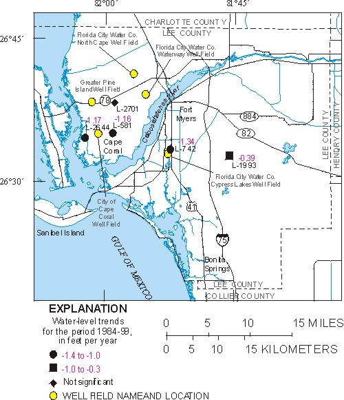
Figure 22. General and statistically significant trends in water level at selected wells in the mid-Hawthorn aquifer.
Return to Table of Contents
Return to Mid-Hawthorn Aquifer Water-Level and Chloride Concentration Trend and Correlation Results
Figure 21.-- Map showing network coverage defined by R2 analysis using index wells in the sandstone aquifer (120K)
Figure 23.-- Graphs showing chloride concentration trends at wells L-735, L-2820, L-2702, L-1109 and L-2640 in the mid-Hawthorn aquifer (91K)
Funding for the USGS to design and maintain this site has been provided through a cooperative agreement with the South Florida Water Management District (SFWMD). Water-level conditions are monitored by the USGS with support from Federal, State, and local cooperators.
| Real-time conditions (de-trended data) |
End-of-month conditions (de-trended data) |
FISC-WRS, home page |
| Accessibility FOIA Privacy Policies and Notices | |
Page Last Modified: Thursday, 27-May-2004 16:03:20 EDT |
|