FISC - Water Resources

ABOUT FISC
DATA CENTER
SCIENCE WEBSITES
OFFICE LOCATIONS
FISC - Headquarters Orlando - 407-803-5500 |
FISC - Water Resources The mission of the Water Discipline, which supports the overall mission of the U.S. Department of the Interior and the U.S. Geological Survey, is to provide the hydrologic information and understanding needed for the best use and management of the Nation's water resources for the benefit of the people of the United States. The USGS provides current ("real-time") stream stage and streamflow (548 sites), water-quality (144 sites), and ground-water levels for 206 sites in Florida. USGS Florida Science HighlightsVolusia Blue Spring—A Hydrological Treasure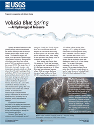
Fact Sheet 2008-3035. Springs are natural openings in the ground through which water beneath the surface discharges into hydrologic features such as lakes, rivers, or the ocean. The beautiful springs and spring rivers are among Florida’s most valued natural resources; their gemlike refreshing waters have been a focal point of life from prehistoric times to the present (2008). The steady flow of freshwater at a nearly constant water temperature attracted animals now long absent from Florida’s landscape.
Water Use in Florida, 2005 and Trends 1950–2005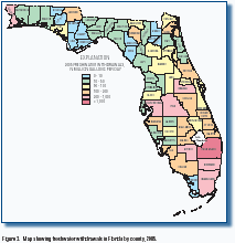
Fact Sheet 2008–3080. Richard L. Marella. Water is among Florida’s most valued resources. The State has more than 1,700 streams and rivers, 7,800 freshwater lakes, 700 springs, 11 million acres of wetlands, and underlying aquifers yielding quantities of freshwater necessary for both human and environmental needs (Fernald and Purdum, 1998). Although renewable, these water resources are finite, and continued growth in population, tourism, and agriculture will place increased demands on these water supplies.
Of Current Interest
Recent Publications
View Our Most Recent PublicationsFlorida Weather |

![]() U.S. Department of the Interior |
U.S. Geological Survey
U.S. Department of the Interior |
U.S. Geological Survey
URL: http://fl.water.usgs.gov/
Page Contact Information: FISC Webmaster
Page Last Modified: 08:26:21 Thu 30 Oct 2008