
USGS/Cascades Volcano Observatory, Vancouver, Washington
Yellowstone Caldera, Wyoming
Maps and Graphics, etc.
-
 [Map,27K,InlineGIF]
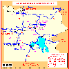
Potentially Active Volcanoes of the Western United States
-- Modified from: Brantley, 1994, Volcanoes of the United States:
USGS General Interest Publication
-
 [Map,22K,InlineGIF]
Yellowstone National Park Vicinity
-- Modified from: Yellowstone National Park, 1998
-
 [Map,19K,inlineGIF]
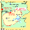
Yellowstone National Park
showing caldera rim and location of 1959 and 1975 quakes
-- Modified from:
Dzurisin, Christiansen, and Pierce, 1995, USGS Open-File Report 95-59
-
 [Map,42K,InlineGIF]
Yellowstone Continuous GPS Network, 1999
-- Modified from: Dzurisin, Yellowstone GPS Network Project, 1999
-
 [Graphic,19K,InlineGIF]
Special Yellowstone GPS monument designed for backcountry sites
-- From: Yellowstone Continuous GPS Network Project, 1999
Return to:
[Yellowstone Caldera Menu] ...
[Wyoming Volcanoes and Volcanics Menu] ...

Use of CVO Material and Copyright Information
URL for CVO HomePage is:
<http://vulcan.wr.usgs.gov/home.html>
URL for this page is:
<http://vulcan.wr.usgs.gov/Volcanoes/Yellowstone/Graphics/framework.html>
If you have questions or comments please contact:
<GS-CVO-WEB@usgs.gov>
09/02/08, Lyn Topinka