
USGS/Cascades Volcano Observatory, Vancouver, Washington
Mount Rainier, Washington
Maps and Graphics, etc.
-
 [Interactive Imagemap] ...
[Map,150K,GIF]
[Interactive Imagemap] ...
[Map,150K,GIF]
Cascade Range Volcanoes
-- Graphic by: Lyn Topinka, 1996
-
 [Map,20K,InlineGIF]
Major West Coast Volcanoes - Washington, Oregon, and California
-
 [Map,27K,InlineGIF]
Potentially Active Volcanoes of the Western United States
-- Modified from: Brantley, 1994, Volcanoes of the United States:
USGS General Interest Publication
-
 [Graphic,70K,InlineGIF]
Cascades Eruptions During the Past 4000 Years
-
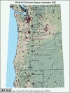
Seismic Monitoring at Cascade Volcanic Centers - The Big Picture
Informational text and shaded relief map
showing locations of all PNSN/NCSN seismic stations operating in the Pacific Northwest as of November, 2003. Map includes the 13 major Cascade volcanic centers.
-- Excerpt from: Moran, 2005, USGS Scientific Investigations Report 2004-5211
-
 [Map,18K,InlineGIF]
Washington State and the Columbia River.
-- includes major volcanoes
-
 [Map,40K,InlineGIF]
University of Washington's Pacific Northwest Seismic Network
-- Modified from: University of Washington Geophysics Program, 1998,
includes seismic station location map and link to PNSN
-
 [Map,30K,InlineGIF]
Oregon and Southern Washington -
University of Washington's Pacific Northwest Seismograph Network
-- Modified from: University of Washington Geophysics Program, 1999,
includes seismic station location map and link to PNSN
-
 [Map,25K,InlineGIF]
Location of Mount Rainier National Park
-- Modified from: Crandell and Mullineaux, 1967,
USGS Bulletin 1238
-
 [Map,29K,InlineGIF]
Mount Rainier Vicinity with Select Place Names
-
 [Map,27K,InlineGIF]
Major Glaciers of Mount Rainier
-- Modified from: Driedger, 1992, USGS Open-File Report 92-474
-
 [Map,33K,InLineGIF]
Major Drainages around Mount Rainier
-- Modified from:
Scott, et.al., 1992, USGS Open-File Report 90-385
-
 [Map,20K,InlineGIF]
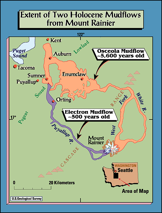
Extent of the Osceola and Electron Mudflows
-- Modified from: Crandell, et.al., 1979
-
 [Map,23K,GIF]
Map showing areas inundated by mudflows from Mount Rainier in the
last 5,600 years
-- Modified from: Sisson, 1995, USGS Open-File Report 95-642
-
 [HTML/PDF] ...
Report and Map Menu
[HTML/PDF] ...
Report and Map Menu
Volcano Hazards from Mount Rainier, Washington, Revised 1998
-- Hoblitt, et.al., 1998, USGS Open-File Report 98-428
-
[Map,270K,PDF]
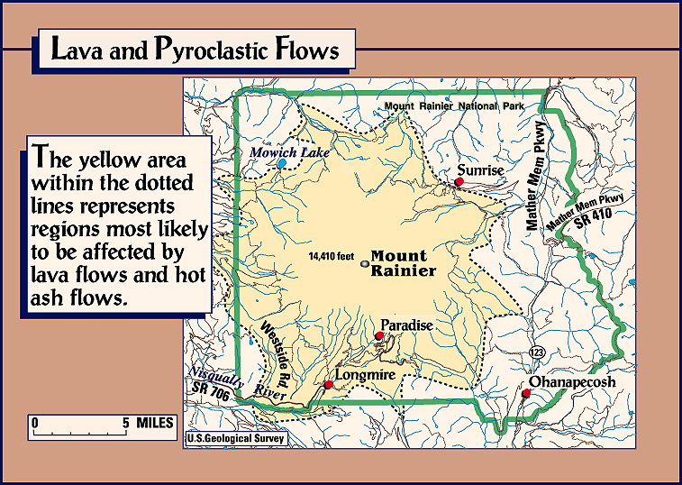
-- Hazards zones for lahars, lava flows, and pyroclastic flows from
Mount Rainier
-- PDF Format
-- From: Scott, et.al., 1998, USGS Fact Sheet 065-97, based on
Hoblitt, et.al., 1998, USGS Open-File Report 98-428
-
 [Map,183K,JPG]
"Poster-Style" Map of the Osceola and Electron Mudflows at Mount Rainier
-
 [Map,313K,JPG]
"Poster-Style" Map of Lava and Pyroclastic Flow Hazards at Mount Rainier
-
 [Map,363K,JPG]
"Poster-Style" Map of Lahar Hazards at Mount Rainier
-
 [Map,209K,JPG]
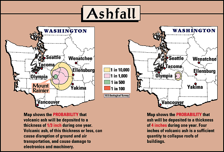
"Poster-Style" Map of Ashfall Hazards at Mount Rainier
-
 [Graphic,10K,InlineGIF]
Profile of shield volcano vs. composite volcano.
-- Modified from: Tilling, Heliker, and Wright, 1987,
includes Mount Rainier
-
 [Image,161K,GIF]
Mount Rainier from the NE showing post-5,600-year-old lava cone
and crater, buried edge of collapse crater (hachured lines)
now partly filled by the snowclad summit crater, which yielded the
sector collapse that formed the Osceola Mudflow. The flow diverged
across Steamboak Prow, the apex of partly barren triangle of rock
at the right side of the photograph, into the main fork of the
White River (center), now the site of the Emmons Glacier, and
northward into the West Fork White River (to right of photo).
Dark rubble on surface of the lower part of the Emmons Glacier is
from the 1963 debris avalanche originating from Little Tahoma Peak.
-- Modified from: Sisson, 1995, USGS Open-File Report 95-642, and
Scott, et.al., 1992, USGS Open-File Report 90-385
-
 [Graphic,15K,GIF]
Holocene tephras from Mount Rainier
-- From: Swanson et.al., 1989, AGU Field Trip Guidebook T106,
taken from Mullineaux, 1974
-
Seismic Monitoring at Cascade Volcanic Centers - The Big Picture
Informational text and shaded relief map
showing locations of all PNSN/NCSN seismic stations operating in the Pacific Northwest as of November, 2003. Map includes the 13 major Cascade volcanic centers.
-- Excerpt from: Moran, 2005, USGS Scientific Investigations Report 2004-5211
-
[Map,30K,InlineGIF]
Oregon and Southern Washington -
University of Washington's Pacific Northwest Seismograph Network
-- Modified from: University of Washington Geophysics Program, 1999,
includes seismic station location map and link to PNSN
-
 [Map,13K,InlineGIF]
University of Washington's Pacific Northwest Seismograph Network -
Mount Rainier Vicinity
-- Modified from: University of Washington Geophysics Program,
1997
-
 [Graphic,19K,InlineGIF]
Mount Rainier Seismicity, 2007
-- Modified from: University of Washington Geophysics Program
-
 [Graphic,19K,InlineGIF]
Mount Rainier Seismicity, 2006
-- Modified from: University of Washington Geophysics Program
-
 [Graphic,19K,InlineGIF]
Mount Rainier Seismicity, 2005
-- Modified from: University of Washington Geophysics Program
-
 [Graphic,20K,InlineGIF]
Mount Rainier Seismicity, 2004
-- Modified from: University of Washington Geophysics Program
-
 [Graphic,20K,InlineGIF]
Mount Rainier Seismicity, 2003
-- Modified from: University of Washington Geophysics Program
-
 [Graphic,20K,InlineGIF]
Mount Rainier Seismicity, 2002
-- Modified from: University of Washington Geophysics Program
-
 [Graphic,20K,InlineGIF]
Mount Rainier Seismicity, 2001
-- Modified from: University of Washington Geophysics Program
-
 [Graphic,20K,InlineGIF]
Mount Rainier Seismicity, 2000
-- Modified from: University of Washington Geophysics Program
-
 [Graphic,22K,InlineGIF]
Mount Rainier Seismicity, 1999
-- Modified from: University of Washington Geophysics Program
-
 [Graphic,15K,InlineGIF]
Mount Rainier Seismicity, 1998
-- Modified from: University of Washington Geophysics Program
-
 [Image,80K,InlineJPG]
Annotated NASA Image:
Mount Rainier, Washington, September 1994.
-- NASA Photo, courtesy NASA Earth From Space;
Modified with text by USGS/CVO.
Return to:
[Mount Rainier Menu] ...
[Mount Rainier Eruptive History Menu] ...
[MORE Cascade Range Maps and Graphics]
[MORE Washington State Maps and Graphics]
[MORE Annotated NASA Images]

Use of CVO Material and Copyright Information
URL for CVO HomePage is:
<http://vulcan.wr.usgs.gov/home.html>
URL for this page is:
<http://vulcan.wr.usgs.gov/Volcanoes/Rainier/Graphics/framework.html>
If you have questions or comments please contact:
<GS-CVO-WEB@usgs.gov>
09/02/08, Lyn Topinka
 [Map,23K,GIF]
 [Map,183K,JPG]
 [Map,313K,JPG]
 [Map,363K,JPG]
 [Map,209K,JPG]
 [Image,161K,GIF]
 [Graphic,15K,GIF]