
USGS/Cascades Volcano Observatory, Vancouver, Washington
Cascade Range Volcanoes and Volcanics
Maps and Graphics, etc.
-
 [InteractiveImagemap,200K,InlineGIF]
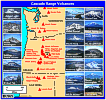
Cascade Range Volcanoes
-- Graphic by: Lyn Topinka, 1996, redone 2001
-
 [Map,16K,InlineGIF] ...
[Map,9K,GIF]
[Map,16K,InlineGIF] ...
[Map,9K,GIF]
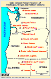
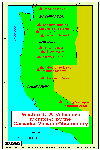
Major Cascade Range Volcanoes of Washington, Oregon, and Northern California
-- Modified from: Tilling, et.al., 1990
-
 [Map,27K,InlineGIF]
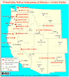
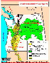
Potentially Active Volcanoes of the Western United States
-- Modified from: Brantley, 1994, Volcanoes of the United States:
USGS General Interest Publication
-
 [Map,20K,InlineGIF]
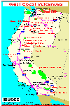
Major West Coast Volcanoes - Washington, Oregon, and California
-
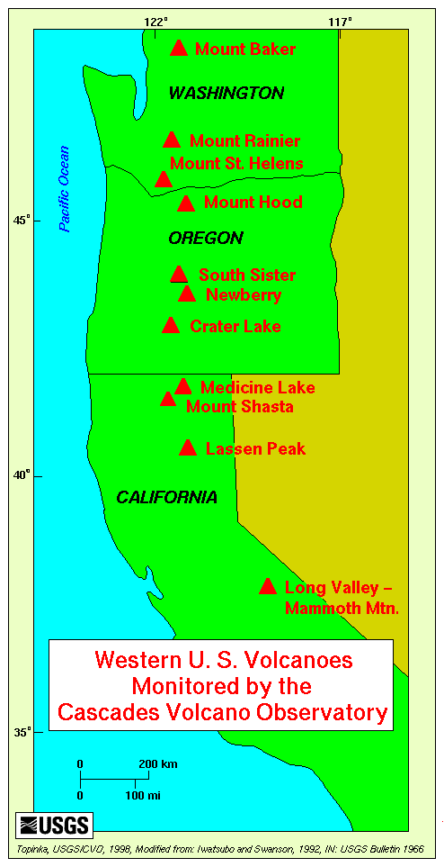
 [Map,21K,GIF]
Map of Western United States,
showing locations of volcanoes monitored by CVO
-- Mount Baker to Long Valley
-- Modified from: Iwatsubo and Swanson, 1992,
IN: USGS Bulletin 1966
-
 [Map,35K,InlineGIF]
Pacific Northwest Volcanics showing the Cascade Range and
Columbia Plateau
-- Modified from: Swanson et.al., 1989,
American Geophysical Union Field Trip Guidebook T106
-
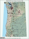
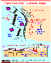
Seismic Monitoring at Cascade Volcanic Centers - The Big Picture
Informational text and shaded relief map
showing locations of all PNSN/NCSN seismic stations operating in the Pacific Northwest as of November, 2003. Map includes the 13 major Cascade volcanic centers.
-- Excerpt from: Moran, 2005, USGS Scientific Investigations Report 2004-5211
-
 [Map,40K,InlineGIF]
University of Washington's Pacific Northwest Seismic Network
-- Modified from: University of Washington Geophysics Program, 1998,
includes seismic station location map and link to PNSN
-
 [Map,30K,InlineGIF]
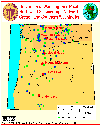
Oregon and Southern Washington -
University of Washington's Pacific Northwest Seismograph Network
-- Modified from: University of Washington Geophysics Program, 1999,
includes seismic station location map and link to PNSN
-
 [Map,27K,InlineGIF]
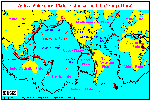
Active Volcanoes, Plate Tectonics, and the "Ring of Fire"
-- Modified from: Tilling, Heliker, and Wright, 1987, and
Hamilton, 1976 ...
[25K,GIF,black/white version]
-
 [Map,20K,InlineGIF]
Plate Tectonics and the Cascade Range
-- Modified from: Tilling, 1985
-
 [Map,20K,InlineGIF]
Juan de Fuca Subduction - Juan de Fuca Ridge - Cascade Range
-- Modified from: Brantley, 1994
-
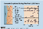 [Graphic,70K,InlineGIF]
[PDF Version] ...
[SmallerGraphic,23K,GIF] ...
Cascades Eruptions During the Past 4000 Years
-- Modified from: USGS Open-File Report 94-585
-
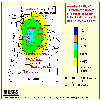 [Map,14K,InlineGIF]
Annual probablility of 10 centimeters or more of tephra accumulation in
Washington and Oregon from major Cascade volcanoes
-- Modified from:
Scott, et.al., 1995, USGS Open-File Report 95-492
-
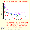 [Graphic,18K,InlineGIF]
Plot of thickness vs. distance from vent for several tephras from
Cascade Range volcanoes.
-- Modified from:
Hoblitt, et.al., 1987, USGS Open-File Report 87-297
Return to:
[Cascade Range Volcanoes Menu]
[California Maps and Graphics Menu]
[Columbia Plateau Maps and Graphics Menu]
[Oregon Maps and Graphics Menu]
[Washington State Maps and Graphics Menu]

Use of CVO Material and Copyright Information
URL for CVO HomePage is:
<http://vulcan.wr.usgs.gov/home.html>
URL for this page is:
<http://vulcan.wr.usgs.gov/Volcanoes/Cascades/Graphics/framework.html>
If you have questions or comments please contact:
<GS-CVO-WEB@usgs.gov>
09/02/08, Lyn Topinka
 [Map,21K,GIF]