Pacific Islands Water Science Center
 |
Recent Hydrologic Conditions, Lahaina District, Maui, HawaiiLast updated July 21, 2008
| |||||||||||||||||||||||||||||||||||||||||||||||||||||||||||||||||||||||||||||||||||||||||||||||||||||||||||||||||||||||||||||||||||||||||||||||||||||||||||||||||||||||||||||||||||||||||||||||||||||||||||||||||||||||||||||||||||||||||||||||||||||||||||||||||||||||||||||||||||||||||||||||||||||||||||||||||||||||||||||||||||||||||||||||||||||||||||||||||||||||
Wells |
Reporting agency |
Most recent month reported |
| Honokahua, Napili, Kanaha, Wai Puka | County of Maui Department of Water Supply | June 2008 |
| P-1 to P-6, Hahakea, Honokowai | Hawaii Water Service Company, Inc. | June 2008 |
| Kapalua | Maui Land and Pineapple Company, Inc. | June 2008 |
| Mahanalua Nui | Launiupoko Water Company, LLC | May 2008 |
| Puamana | Puamana Community Association | May 2008 |
| Olowalu Elua | Olowalu Elua Assoc., LLP | May 2008 |
The 12-month moving mean of reported pumping in the Honolua aquifer system as of June 2008 was 2.49 Mgal/d, a decrease of 0.05 Mgal/d relative to the 12-month moving mean from one year previous.
The 12-month moving mean of reported pumping in the Honokowai aquifer system as of June 2008 was 3.57 Mgal/d, an increase of 0.44 Mgal/d relative to the 12-month moving mean from one year previous.
The 12-month moving mean of reported pumping in the Launiupoko aquifer system as of June 2008 was 0.63 Mgal/d, an increase of 0.02 Mgal/d relative to the 12-month moving mean from one year previous.
The 12-month moving mean of reported pumping in the Olowalu aquifer system as of June 2008 was 0.05 Mgal/d, an increase of 0.02 Mgal/d relative to the 12-month moving mean from one year previous.
No pumping has been reported for the Ukumehame aquifer system for the year prior to June 2008.
References:
Commission on Water Resource Management, 1990, Water Resources Protection Plan: prepared by George A.L. Yuen and Associates, Inc., for Department of Land and Natural Resources, State of Hawaii, 262 p.

Honolua aquifer system total reported pumpage and 12-month moving mean of total pumpage, 1984 to present.

Honokowai aquifer system total reported pumpage and 12-month moving mean of total pumpage, 1984 to present.

Launiupoko aquifer system total reported pumpage and 12-month moving mean of total pumpage, 1984 to present.

Olowalu aquifer system total reported pumpage and 12-month moving mean of total pumpage, 1984 to present.

Ukumehame aquifer system total reported pumpage and 12-month moving mean of total pumpage, 1984 to present.
Table 1. Reported pumpage, in million gallons per day, for aquifer systems in the Lahaina District, Maui, Hawaii, July 2007-June 2008.
| Month | Honolua | Honokowai | Launiupoko | Olowalu | Ukumehame | Lahaina District total |
| July-07 | 3.04 |
4.11 |
0.61 |
0.09 |
0.00 |
7.84 |
| August-07 | 2.86 |
4.07 |
0.73 |
0.07 |
0.00 |
7.73 |
| September-07 | 2.60 |
5.13 |
0.66 |
0.05 |
0.00 |
8.44 |
| October-07 | 2.41 |
3.74 |
0.63 |
0.05 |
0.00 |
6.84 |
| November-07 | 2.09 |
3.15 |
0.49 |
0.05 |
0.00 |
5.78 |
| December-07 | 2.27 |
2.72 |
0.69 |
0.04 |
0.00 |
5.72 |
| January-08 | 2.34 |
2.98 |
0.53 |
0.04 |
0.00 |
5.89 |
| February-08 | 2.16 |
3.00 |
0.47 |
0.05 |
0.00 |
5.69 |
| March-08 | 2.58 |
3.55 |
0.69 |
0.05 |
0.00 |
6.88 |
| April-08 | 2.38 |
3.07 |
0.69 |
0.05 |
0.00 |
6.19 |
| May-08 | 2.74 |
3.33 |
0.72 |
0.06 |
0.00 |
6.86 |
| June-08 | 2.39 |
4.03 |
0.67 |
0.00 |
0.00 |
7.09 |
12-month moving mean June 2008 |
2.49 |
3.57 |
0.63 |
0.05 |
0.00 |
|
| State sustainable yield value | 8 |
8 |
8 |
3 |
3 |
|
| Change in 12-month moving mean from 1 year previous | -0.05 |
0.44 |
0.02 |
0.02 |
0.00 |
Note: 12-month moving mean is the mean of the monthly pumpage values for a given month and the previous 11 months; Totals in bold are incomplete when pumping data from the State of Hawaii Commission on Water Resource Management does not include all known wells in the aquifer system.
Data collected by the U. S. Geological Survey in cooperation with the State of Hawaii Commission on Water Resource Management. Data after September 30, 2006 are provisional and subject to revision.

Water levels in the Lahaina District have been monitored for various periods of time since 1935. Currently, the USGS measures water levels in one well in the Lahaina District, at Alaeloa (well 5840-01). The Alaeloa well is located in the Honolua aquifer system. The well was drilled for the State of Hawaii in 1964 and continuous monitoring was done from 1975 to 1993 and from July 2001 to the present. From 1993 to July, 2001, only occasional measurements were made. The well is open to the aquifer between altitudes of -7 and -17 ft.
Fresh ground water in the Lahaina District occurs mainly in freshwater-lens systems and dike-impounded systems (Yamanaga and Huxel, 1969; Souza, 1981). A freshwater-lens system includes a lens-shaped freshwater body, an intermediate transition zone of brackish water, and underlying saltwater. The thickness of the transition zone is dependent on the extent of mixing between freshwater and saltwater. Within the study area, freshwater-lens systems are found in dike-free volcanic rocks of high permeability and sedimentary deposits. West Maui lacks a significant coastal confining unit; therefore, water levels in the freshwater-lens system generally are less than 7 ft above sea level. In the Lahaina District, simultaneous water levels were reported for 11 wells from February 1979 and 1980 and ranged from 2.0 to 6.5 ft above mean sea level (Souza, 1981). Available data indicate that water levels in the Alaeloa well, which penetrates the freshwater lens system, respond mainly to changes in ocean level at the coast.
Additional information about ground water in the Lahaina District can be found in:
"Ground-water status report, Lahaina District, Maui, Hawaii": U.S. Geological Survey Open-File Report 81-549 by W.R. Souza, 1981.
"Preliminary report on the water resources of the Lahaina District, Maui: State of Hawaii", Department of Land and Natural Resources, Division of Water and Land Development, Circular C51, 47 p. by George Yamanaga and C.J. Huxel, 1969.
click image to show ocean level record, double click image to remove ocean level record
Recent water-level record compared with historical data

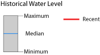
The daily maximum and minimum data show how recent conditions compare to the range of daily water levels measured in the historical record. The entire period of record is used to estimate daily maximum, minimum, and median water levels. The spikes appear because data prior to 1994 were reported at 5-day intervals.
Chloride data provided by the County of Maui Department of Water Supply.

Changes in chloride concentration of pumped water over time can be a function of the pumping rate of a particular well, pumping at nearby wells, depth of the well, and recharge to the aquifer. Therefore, the evaluation of aquifer conditions based on chloride-concentration trends from the pumped wells has limitations. In the Lahaina District, chloride concentrations in many of the pumped wells appear to increase directly in response to increased pumping at those wells.
For some of the MDWS wells in the Lahaina District, chloride concentration of the pumped water has been above the USEPA secondary maximum contaminant level of 250 mg/L at increased pumping rates. Chloride concentrations have been as high as 875 mg/L in the Kanaha wells. Chloride concentrations have occasionally exceeded 250 mg/L in Honokahua, Napili, and Wai Puka wells.
Chloride concentrations are currently only available for MDWS and ML&P wells.
Chloride concentrations of pumped water during April 2008 were generally the same at all of the well fields with the exception of Kanaha.
Kapalua chloride concentrations have remained below 30 mg/l.
Honokahua 573 chloride concentration in Apr 2008 was 17 mg/L, whereas in Apr-Jun 2007 chloride concentrations were 16 to 18 mg/l. Honokahua 572 chloride concentrations were not measured during Apr-Jun 2008.
Napili 569 chloride concentration during Apr 2008 was 168 mg/l, whereas in Apr-Jun 2007 chloride concentrations were 153 to 159 mg/L. Napili 570 chloride concentration during Apr 2008 was 89 mg/L, whereas in Apr-Jun 2007 chloride concentration was 39 mg/l. Napili 571 chloride concentration during Apr-Jun 2008 was not measured, whereas in Apr-Jun 2007 chloride concentrations were 78 to 85 mg/L.
Kanaha 575 chloride concentration during Apr 2008 was 328 mg/L, whereas in Apr-Jun 2007 chloride concentrations were 177 to 263 mg/L. Kanaha 576 chloride concentration during Apr 2008 was 235 mg/L, whereas in Apr-Jun 2007 chloride concentrations were 216 to 250 mg/L.
Wai Puka 559 chloride concentration during Apr 2008 was 84
mg/L, whereas in Apr-Jun 2007 chloride concentrations were 58 to 74 mg/L.
Wai Puka 560 chloride concentrations during Apr 2008 were 83
mg/L, whereas in Apr-Jun 2007 chloride concentrations were 76 to 108 mg/L.

Chloride concentrations and combined monthly pumpage for Kapalua well field, 1985 to present.
Chloride concentrations and combined monthly pumpage for Honokahua pumps 572 and 573, 1985 to present.
Chloride concentrations and monthly pumpage for Napili pumps 569, 570, and 571, 1985 to present.
Chloride concentrations and combined monthly pumpage for Kanaha wells 575 and 576, 1985 to present.
Chloride concentrations and combined monthly pumpage for Wai Puka wells
559 and 560, 1985 to present.
Mahinahina deep monitor well data collected by the State of Hawaii Commission on Water Resource Management.
 Introduction
 The Mahinahina deep monitor well, drilled to an altitude of -599 ft, penetrates through the transition zone. Because the amount of water that can be developed from a freshwater lens for potable use is constrained by the salinity of the water, the altitude of the top of the transition zone (where chloride concentration is 2 percent that of seawater) and the thickness of the transition zone are important. Fluid conductivity data have been collected from the Mahinahina deep monitor well since 2001. The movement of the transition zone in a freshwater-lens system is typically in response to water-level changes caused by variations in pumping and recharge. Because the well is uncased below sea level, it is possible that the salinity of the water measured at any depth in the well is affected by borehole flow. Thus, salinity for a given depth may not reflect the actual salinity of water in the aquifer at that depth. Nevertheless, measuring salinity with depth over time provides a general pattern of transition-zone thickness and relative movement.
The profile plot indicates no significant rise in the mid-point of the transition zone since 2001. A plot of the position of two salinity values (2-percent and 50-percent seawater salinity) in the transition zone also shows no significant rise of the transition zone through time. The Mahinahina deep monitor well is currently not being monitored by the State of Hawaii Commission on Water Resource Management.
Fluid conductivity profiles for the Mahinahina deep monitor well, August 2001 and June 2007.
Altitude of the top (2-percent seawater salinity) and mid-point (50-percent seawater salinity) of the transition zone, Mahinahina deep monitor well, 2001 to present.
Streamflow data collected by the U. S. Geological Survey in cooperation with the State of Hawaii Commission on Water Resource Management. Data after September 30, 2006 are provisional and subject to revision. Diversion data provided by the State of Hawaii Commission on Water Resource Management.

Streams in the Lahaina District flow from the wet interior of the West Maui mountains where the water has cut deep valleys into the low-permeability volcanic dike compartments which impound ground-water to high altitudes. Ground water leaking from these breached dike compartments provides flow in the streams (base flow) even during prolonged periods of little or no rainfall. Downstream of the USGS gaging stations, many of the streams are diverted and the water is transported by tunnels and ditches for use in agriculture and domestic needs. The stream diversion structures are designed to capture all of the the low flow, and therefore, the streams are frequently dry in some sections downstream of the diversions.
Currently, four streams in west Maui are gaged by the USGS (Waihee River, Iao, Kahakuloa, and Honokohau Streams) with Honokohau being the most relevant to the hydrology of the Lahaina District. Streamflow has been measured in Honokohau Stream (USGS gaging station 16620000) from 1913 to the present (now a real-time gage) and the median flow during that period was about 15.5 Mgal/d (Flow Statistics for USGS Stream-Gaging Stations Operated in Hawaii from 1909-2005). historical streamflow data is available from several other streams and diversion ditches in the Lahaina District (link to historical data on NWISWeb).
Streamflow in Honokohau Stream during April-June 2008 was 55 percent of the median for those months, and for the past year streamflow was 108 percent of median annual flow.
The completeness of the reported diversion data varies depending on what data has been reported to the State of Hawaii Commission on Water Resource Management by the various water users (see table 1 below). The most recent diversion data reported is current through March 2008.
Further information about streams and diversions in the District can be found in:
"Availability and Distribution of Base Flow in Lower Honokohau Stream, Island of Maui": U.S. Geological Survey Water-Resources Investigations Report 03-4060, 37 p. by Richard Fontaine, 2003
"Preliminary report on the water resources of the Lahaina District, Maui: State of Hawaii": Department of Land and Natural Resources, Division of Water and Land Development, Circular C51, 47 p. by George Yamanaga and C.J. Huxel, 1969.
"Agricultural water use and development plan": State of Hawaii, Department of Agriculture, 256 p. by Water Resource Associates, Revised 2004.
"Sugar water, Hawaii's plantation ditches": University of Hawaii Press, Honolulu, Hawaii, by Carol Wilcox, 1996.


Monthly mean discharge data show how recent conditions compare to the range of monthly discharge measured in the historical record. The entire period of record is used to estimate the historical maximum and minimum discharge as well as several percentiles.
[nr, not reported; ML&P, Maui Land and Pineapple Company, Inc.; LIC, Launiupoko Irrigation Company, LLC; DWS, County of Maui Department of Water Supply; OWC, Olowalu Water Company, LLC; no reported diversions from Honokahua, Kahana, or Honokowai Streams]
Jul-07 |
Aug-07 |
Sep-07 |
Oct-07 |
Nov-07 |
Dec-07 |
Jan-08 |
Feb-08 |
Mar-08 |
Apr-08 |
May-08 |
Jun-08 |
|
| Mean daily flow at Honokohau Stream gaging station (16614000) [upstream of all diversions] | 24.37 |
15.39 |
24.20 |
21.16 |
15.98 |
47.54 |
31.17 |
37.10 |
17.40 |
14.48 |
12.95 |
11.52 |
| Mean
daily diversion from Honokohau Stream
(ML&P) |
11.40 |
10.06 |
9.11 |
9.81 |
12.96 |
20.53 |
15.85 |
13.90 |
12.69 |
10.40 |
9.53 |
nr |
| Mean daily diversion from Kahoma Stream | ||||||||||||
Kahoma Stream (LIC) |
7.21 |
5.28 |
5.98 |
4.01 |
4.37 |
7.39 |
7.17 |
2.43 |
4.52 |
6.27 |
3.94 |
nr |
Kanaha Stream (DWS) |
nr
|
nr
|
nr
|
nr
|
nr
|
nr
|
nr
|
nr
|
nr
|
nr
|
nr
|
nr
|
| Total | 7.21 |
5.28 |
5.98 |
4.01 |
4.37 |
7.39 |
7.17 |
2.43 |
4.52 |
6.27 |
3.94 |
nr |
| Mean daily diversion from Kauaula Stream (LIC) | 5.84 |
5.22 |
5.46 |
5.90 |
5.40 |
5.06 |
6.50 |
5.70 |
5.73 |
5.15 |
4.57 |
3.70 |
| Mean daily diversion from Launiupoko Stream (LIC) | 0.47 |
0.41 |
0.47 |
0.30 |
0.16 |
0.41 |
0.53 |
0.47 |
0.58 |
0.47 |
0.36 |
0.34 |
| Mean daily diversion from Olowalu Stream (OWC) | 3.85 |
6.29 |
7.14 |
3.69 |
3.45 |
4.02 |
4.68 |
4.87 |
4.51 |
4.45 |
3.76 |
1.90 |
| Mean daily diversion from Ukumehame Stream | nr
|
nr
|
nr
|
nr
|
nr
|
nr
|
nr
|
nr
|
nr
|
nr
|
nr
|
nr
|
| Total reported diversions from all streams | 28.77 |
27.25 |
28.16 |
23.70 |
26.34 |
37.41 |
34.73 |
27.36 |
28.03 |
26.74 |
22.18 |
5.94 |


![]() U.S. Department of the Interior | U.S. Geological Survey
U.S. Department of the Interior | U.S. Geological Survey
URL: http://hi.water.usgs.gov/lahaina/lahaina_tab.htm
Page Contact Information:
Page Last Modified: Monday, 01-Sep-2008 00:22:17 EDT (sbg)

 Introduction


