|
>HOME
>NEWSROOM
>DATA
>PUBLICATIONS
>PROJECTS
>ABOUT US
|
|
|
Daily Streamflow Conditions
|
|
Click map to view current
streamflow conditions.
|
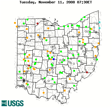
The colored dots on this map depict streamflow conditions as a
percentile, which is computed from the period of record for the current day of the year.
Only stations with at least 30 years of record are used.
The gray circles indicate other stations that were not ranked in percentiles either because they have fewer than 30 years of record or because they report parameters other than
streamflow. Some stations, for example, measure stage only.
|
|
|
|
|
Links
|
|
NWISWeb
-- obtain real-time and historic streamflow, groundwater, and
water-quality data.
Cooperators
Contact
Us

Ohio
Water Resources Council
|
|
|
|
|
|
|
Links for educators and students
|
|
|
|
Regional Workshops and Seminars
|
|
|
|
Guest Lecture Series
|
-
"The Historical, Climatic and Socioeconomic Context for U.S.
Megadrought"
Dr. Julio L. Betancourt USGS, Desert Laboratory, Tucson, Arizona, Monday, April 26, 2004
-
Previous Guest Lecturers (MS Word file)
|
|
|
Alphabetical Index of Links
|
|
|
|
|
|
|
|
|
|
*VOLUNTEER*
USGS Volunteer for a Changing World
The Government Volunteer
Website
|


