|
|
|
Metadata
|
|
ID
|
81002
|
|
Also Known As
|
81002
OCNS091
O-91-81-NE
|
|
Abstract
|
United States Geological Survey, Woods Hole, Massachusetts.
Chief Scientist: Brad Butman. Data (navigation) of field
activity 81002 (O-91-81-NE) in Gulf of Maine EEZ from
01/16/1981 to 01/22/1981
|
|
Organization
|
United States Geological Survey, Woods Hole, Massachusetts
|
|
Project/Theme
|
North Atlantic Environmental Assessment
|
|
Chief Scientist
|
Brad Butman
|
|
Platform
|
Oceanus
|
|
Area of Operation
|
Gulf of Maine EEZ
|
|
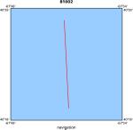
Location map
|
|
|
Bounding Coordinates
|
41.50000
-71.00000 -67.00000
40.00000
|
|
Dates
|
01/16/1981 (JD 016) to 01/22/1981 (JD 022)
|
|
Analog Materials
|
No analog holdings.
|
|
Index map

|
|
|
Crew
|
|
Brad Butman
|
Chief Scientist, USGS Woods Hole
|
|
Paul C. Howland
|
Ship Captain, WHOI
|
|
Mike Bothner
|
Unspecified, USGS Woods Hole
|
|
Dave Folger
|
Unspecified, USGS Woods Hole
|
|
John Larson
|
Unspecified, USGS Woods Hole
|
|
Frank Musialowski
|
Unspecified, USGS Woods Hole
|
|
Marlene Noble
|
Unspecified, USGS Woods Hole
|
|
Carol Parmenter
|
Unspecified, USGS Woods Hole
|
|
Rick Rendigs
|
Unspecified, USGS Woods Hole
|
|
Polly Shoukimas
|
Unspecified, USGS Woods Hole
|
|
Bill Strahle
|
Unspecified, USGS Woods Hole
|
|
Andy Eliason
|
Unspecified, Eliason Data Services
|
|
Rose Petrecca
|
Unspecified, WHOI
|
|
|
Equipment Used
|
|
|
Purpose
|
|
|
Got Help?
|
For 81002, we would appreciate any information on -- activity type, analog materials, contract, days at sea, dive count, funding, information specialist, information to be derived, kms of navigation, national plan, NGDC Info, notes, owner, ports, project number, publications, scanned materials, seismic description, station count, station description, submersible, summary, tabulated info.
|
|