Project: |
FEWS NET |
||
| Leader: | James
Rowland, rowland@usgs.gov
|
||
| Overview: | FEWS NET was designed to monitor (and forecast when possible)
incidence of drought and flooding in Africa in order to identify problems
in the food supply system that could potentially lead to famine or other
food-insecure conditions. The purpose of FEWS NET is to collect, analyze,
and distribute information to decision makers regarding potential or current
famine/flood situations, allowing them to authorize timely measures to prevent
food-insecure conditions. FEWS NET supports data collection and analysis
in 17 African countries. Since 1987, USGS/EDC has provided timely access
to satellite data/products in order to identify potential and current problems
related to crop conditions and/or flood risk throughout Africa. |
  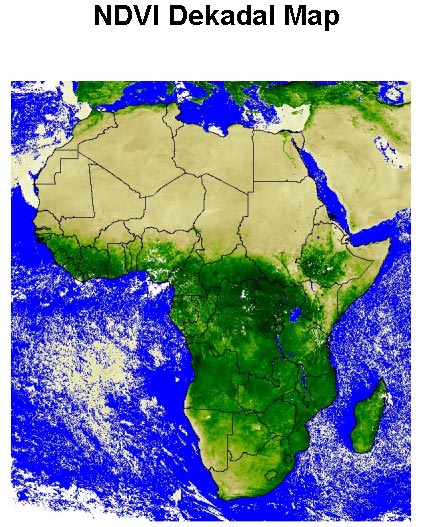 NDVI Dekadal image  Rainfall Dekadal image |
|
| USGS Mission Tie In: |
This project provides numerous benefits to several Science
Disciplines at the USGS: USGS Data and Image Processing Support - remote sensing, image processing and interpretation, and GIS analyses. Provides access to relevant satellite data (e.g., AVHRR-derived normalized difference vegetation index (NDVI); and Meteosat-derived rainfall estimates). Agro-meteorological Product Development, such as rainfall estimate algorithm enhancement, and crop-specific water requirement satisfaction index (WRSI) modeling and yield reduction assessment. Spatial Data Modeling and Forecasting - Stream Flow Model. Develops stream flow estimates for flood risk monitoring, as well as scenarios for flood preparedness, in GIS environments. Data Archive and Dissemination - repository of FEWS NET Africa-wide data archive, and Africa Data Dissemination Service (ADDS) server. |
||
| Discipline: | Geography
primarily, with Water
as partner. |
||
| Locations: | FEWS NET supports data collection and analysis in 17 African
countries: Burkina Faso, Chad, Mali, Mauritania, and Niger; Eritrea, Ethiopia,
Kenya, Rwanda, Somalia, Southern Sudan, and Tanzania; Malawi, Mozambique,
Uganda, Zambia, and Zimbabwe. FEWS NET has now expanded to a global project
with USAID this technology to Afghanistan, Southeast Asia and Central America. |
||
| Web Sites: |
EROS Data Center |
||
| Partners: | U.S. Agency for International Development (USAID) Chemonics International NASA/Goddard Space Flight Center (GSFC) NOAA/Climate Prediction Center (CPC) UN Food and Agriculture Organization (FAO/Rome) AGRHYMET Regional Center (Niamey, Niger) SADC/Regional Remote Sensing Project (Harare, Zimbabwe) SADC/Water Sector Coordinating Unit (Lesotho) Drought Monitoring Center, Nairobi (DMCN)(Kenya) Regional Centre for Mapping of Resources for Development (RCMRD) (Nairobi, Kenya) Mozambique institutions: ARA-Sul, CENACARTA, University Eduardo Mondlane Other: Kenya Meteorological Department (KMD), Nairobi; Drought Monitoring Centre (DMC), Harare; South Africa Weather Service, Pretoria. |
||

![]() U.S. Department of the Interior |
U.S. Geological Survey
U.S. Department of the Interior |
U.S. Geological Survey
URL: http://international.usgs.gov/projects/prjfewsnet.htm
Page Contact Information:
Page Contact Information: IP Web Team
Page Last Modified: Wednesday, 25-Jun-2008 14:55:06 EDT