National Water Information System: Web Interface

  USGS Water Resources    


News: Recent changes

USGS Real-Time Water Data for Montana


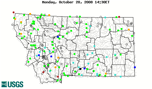
Daily Streamflow Conditions

Select a site to retrieve data and station information.
Stream gage levels in Montana, relative to 30 year average. 06154100: Flow=15cfs,Stage=0.72ft,Floodstage=21.0ft,2008-10-04 00:15,Low,Milk River near Harlem MT 12325500: Flow=50cfs,Stage=1.20ft,2008-10-03 23:30,>90,Flint Creek near Southern Cross MT 12306500: Flow=48cfs,Stage=3.37ft,Floodstage=9.0ft,2008-10-04 00:45,<10,MOYIE RIVER AT EASTPORT ID 06185500: Flow=4570cfs,Stage=2.69ft,Floodstage=19.0ft,2008-10-04 01:00,<10,Missouri River near Culbertson MT 06054500: Flow=2540cfs,Stage=3.70ft,Floodstage=10.5ft,2008-10-03 22:30,<10,Missouri River at Toston MT 06016000: Flow=93cfs,Stage=0.58ft,2008-10-03 22:15,<10,Beaverhead River at Barretts MT 06061500: Flow=13cfs,Stage=0.44ft,2008-10-04 01:30,<10,Prickly Pear Creek near Clancy MT 06324970: Flow=8.5cfs,Stage=2.38ft,Floodstage=13.0ft,2008-10-04 01:30,76-90,LITTLE POWDER RIVER AB DRY CREEK, NEAR WESTON, WY 06154550: Flow=11cfs,Stage=2.86ft,2008-10-04 00:45,76-90,Peoples Cr bl Kuhr Coulee nr Dodson MT 06154410: Flow=2.5cfs,Stage=0.64ft,2008-10-03 23:00,76-90,Little Peoples Creek near Hays MT 06090800: Flow=6110cfs,Stage=2.43ft,Floodstage=13.5ft,2008-10-04 01:30,76-90,Missouri River at Fort Benton MT 06088500: Flow=156cfs,Stage=3.83ft,Floodstage=7.0ft,2008-10-04 01:45,76-90,Muddy Creek at Vaughn MT 06019500: Flow=152cfs,Stage=3.00ft,2008-10-04 01:45,76-90,Ruby River above reservoir near Alder, MT 12355000: Flow=186cfs,Stage=4.48ft,Floodstage=10.5ft,2008-10-04 01:45,10-24,Flathead River at Flathead British Columbia 12304500: Flow=115cfs,Stage=3.00ft,Floodstage=8.0ft,2008-10-03 22:15,10-24,Yaak River near Troy MT 12301933: Flow=4670cfs,Stage=18.13ft,Floodstage=27.5ft,2008-10-04 00:00,10-24,Kootenai River bl Libby Dam nr Libby MT 06334500: Flow=1.0cfs,Stage=2.17ft,Floodstage=12.0ft,2008-10-04 00:30,10-24,LITTLE MISSOURI R AT CAMP CROOK,SD 06200000: Flow=107cfs,Stage=2.37ft,Floodstage=7.0ft,2008-10-04 00:15,10-24,Boulder River at Big Timber MT 06181000: Flow=7.7cfs,Stage=1.07ft,Floodstage=15.5ft,2008-10-03 23:45,10-24,Poplar River near Poplar MT 06178500: Flow=2.1cfs,Stage=5.20ft,Floodstage=10.0ft,2008-10-03 22:45,10-24,East Poplar River at International Bndry 06133000: Flow=0.184cfs,Stage=0.624ft,Floodstage=7.0ft,2008-10-04 01:00,10-24,Milk River at Western Crossing of Int Bndry 06108000: Flow=18cfs,Stage=1.18ft,Floodstage=9.0ft,2008-10-03 22:15,10-24,Teton River near Dutton MT 06052500: Flow=506cfs,Stage=3.93ft,Floodstage=8.0ft,2008-10-03 22:30,10-24,Gallatin River at Logan MT 06041000: Flow=1300cfs,Stage=2.13ft,2008-10-04 01:45,10-24,Madison River bl Ennis Lake nr McAllister MT 06038500: Flow=740cfs,Stage=1.52ft,2008-10-04 00:00,10-24,Madison River bl Hebgen Lake nr Grayling MT 05017500: Flow=198cfs,Stage=1.99ft,2008-10-04 01:15,10-24,St. Mary River near Babb MT 13039500: Flow=24cfs,Stage=4.77ft,2008-10-03 22:45,25-75,HENRYS FORK NR LAKE ID 12390700: Flow=56cfs,Stage=0.80ft,2008-10-03 23:15,25-75,Prospect Creek at Thompson Falls MT 12389500: Flow=152cfs,Stage=2.55ft,Floodstage=7.5ft,2008-10-03 22:15,25-75,Thompson River near Thompson Falls MT 12389000: Flow=10700cfs,Stage=4.74ft,Floodstage=16.0ft,2008-10-04 00:45,25-75,Clark Fork near Plains MT 12372000: Flow=7560cfs,Stage=5.52ft,Floodstage=18.0ft,2008-10-04 00:25,25-75,Flathead River near Polson MT 12370000: Flow=589cfs,Stage=2.56ft,Floodstage=6.5ft,2008-10-03 23:45,25-75,Swan River near Bigfork, MT 12363000: Flow=3550cfs,Stage=3.38ft,Floodstage=14.0ft,2008-10-04 01:15,25-75,Flathead River at Columbia Falls MT 12362500: Flow=2070cfs,Stage=5.40ft,2008-10-04 01:30,25-75,S F Flathead River nr Columbia Falls MT 12359800: Flow=503cfs,Stage=5.14ft,2008-10-04 01:45,25-75,S F Flathead R ab Twin C nr Hungry Horse MT 12358500: Flow=712cfs,Stage=1.93ft,Floodstage=10.0ft,2008-10-04 01:45,25-75,M F Flathead River near West Glacier MT 12355500: Flow=842cfs,Stage=2.02ft,Floodstage=13.0ft,2008-10-04 01:45,25-75,N F Flathead River nr Columbia Falls MT 12354500: Flow=3190cfs,Stage=5.59ft,Floodstage=19.0ft,2008-10-03 23:00,25-75,Clark Fork at St. Regis MT 12353000: Flow=2460cfs,Stage=1.77ft,Floodstage=11.0ft,2008-10-04 01:00,25-75,Clark Fork below Missoula MT 12344000: Flow=270cfs,Stage=1.56ft,Floodstage=7.5ft,2008-10-03 22:45,25-75,Bitterroot River near Darby MT 12342500: Flow=122cfs,Stage=1.47ft,2008-10-04 01:45,25-75,West Fork Bitterroot River nr Conner MT 12340500: Flow=1510cfs,Stage=2.88ft,Floodstage=10.0ft,2008-10-04 01:00,25-75,Clark Fork above Missoula MT 12340000: Flow=634cfs,Stage=2.22ft,Floodstage=10.0ft,2008-10-04 01:45,25-75,Blackfoot River near Bonner MT 12335500: Flow=8.6cfs,Stage=1.52ft,2008-10-03 22:30,25-75,Nevada Cr ab reservoir, nr Helmville, MT 12334510: Flow=278cfs,Stage=4.05ft,Floodstage=8.0ft,2008-10-03 22:15,25-75,Rock Creek near Clinton MT 12332000: Flow=45cfs,Stage=1.51ft,2008-10-04 00:00,25-75,Middle Fork Rock Cr nr Philipsburg MT 12329500: Flow=96cfs,Stage=2.45ft,2008-10-04 01:15,25-75,Flint Creek at Maxville MT 12324590: Flow=44cfs,Stage=1.11ft,2008-10-03 22:15,25-75,Little Blackfoot River near Garrison MT 12305000: Flow=5230cfs,Stage=10.86ft,2008-10-04 00:15,25-75,KOOTENAI RIVER AT LEONIA ID 12302055: Flow=101cfs,Stage=2.98ft,Floodstage=7.5ft,2008-10-04 00:15,25-75,Fisher River near Libby MT 12301300: Flow=85cfs,Stage=2.18ft,2008-10-03 23:45,25-75,Tobacco River near Eureka MT 06329500: Flow=7390cfs,Stage=5.16ft,Floodstage=19.0ft,2008-10-04 01:00,25-75,Yellowstone River near Sidney MT 06326500: Flow=120cfs,Stage=1.37ft,Floodstage=9.0ft,2008-10-04 01:15,25-75,Powder River near Locate MT 06324500: Flow=125cfs,Stage=2.29ft,2008-10-04 01:45,25-75,Powder River at Moorhead MT 06309000: Flow=7220cfs,Stage=3.60ft,Floodstage=13.0ft,2008-10-04 01:00,25-75,Yellowstone River at Miles City MT 06308500: Flow=118cfs,Stage=2.14ft,Floodstage=11.0ft,2008-10-04 01:15,25-75,Tongue River at Miles City MT 06307500: Flow=204cfs,Stage=11.26ft,2008-10-04 01:30,25-75,Tongue River at Tongue R Dam nr Decker MT 06306300: Flow=208cfs,Stage=2.77ft,2008-10-04 01:45,25-75,Tongue River at State Line nr Decker MT 06295000: Flow=7230cfs,Stage=2.36ft,Floodstage=10.0ft,2008-10-04 01:00,25-75,Yellowstone River at Forsyth MT 06294500: Flow=2740cfs,Stage=2.01ft,2008-10-04 00:15,25-75,Bighorn River ab Tullock Cr nr Bighorn MT 06294000: Flow=126cfs,Stage=2.49ft,Floodstage=8.0ft,2008-10-03 23:30,25-75,Little Bighorn River near Hardin MT 06291500: Flow=25cfs,Stage=2.38ft,2008-10-04 00:15,25-75,Lodge Grass Cr ab Willow Cr diversion, nr Wyola MT 06290000: Flow=15cfs,Stage=1.58ft,2008-10-04 00:15,25-75,Pass Creek near Wyola MT 06289000: Flow=100cfs,Stage=1.73ft,2008-10-04 00:15,25-75,Little Bighorn River at State Line nr Wyola MT 06287000: Flow=2740cfs,Stage=61.74ft,2008-10-04 00:45,25-75,Bighorn River near St. Xavier, MT 06216000: Flow=25cfs,Stage=3.14ft,2008-10-04 00:15,25-75,Pryor Creek at Pryor MT 06214500: Flow=3440cfs,Stage=2.97ft,Floodstage=13.0ft,2008-10-04 01:15,25-75,Yellowstone River at Billings MT 06211500: Flow=32cfs,Stage=2.81ft,2008-10-03 23:00,25-75,Willow Creek near Boyd MT 06211000: Flow=49cfs,Stage=2.14ft,2008-10-04 00:15,25-75,Red Lodge Cr ab Cooney Re nr Boyd MT 06209500: Flow=87cfs,Stage=5.29ft,Floodstage=7.5ft,2008-10-03 23:15,25-75,Rock Creek near Red Lodge MT 06208500: Flow=466cfs,Stage=1.95ft,2008-10-03 22:30,25-75,Clarks Fork Yellowstone River at Edgar MT 06207500: Flow=191cfs,Stage=0.82ft,Floodstage=7.5ft,2008-10-03 22:45,25-75,Clarks Fork Yellowstone River nr Belfry MT 06205000: Flow=451cfs,Stage=2.13ft,Floodstage=6.5ft,2008-10-03 22:30,25-75,Stillwater River near Absarokee MT 06204050: Flow=116cfs,Stage=1.02ft,2008-10-03 22:30,25-75,West Rosebud Creek near Roscoe MT 06192500: Flow=1970cfs,Stage=3.28ft,Floodstage=8.5ft,2008-10-04 01:45,25-75,Yellowstone River near Livingston MT 06191500: Flow=1520cfs,Stage=1.95ft,Floodstage=11.0ft,2008-10-03 22:15,25-75,Yellowstone River at Corwin Springs MT 06191000: Flow=132cfs,Stage=2.14ft,2008-10-04 01:45,25-75,Gardner River near Mammoth YNP 06188000: Flow=155cfs,Stage=1.29ft,Floodstage=15.0ft,2008-10-04 01:15,25-75,Lamar River nr Tower Ranger Station YNP 06178000: Flow=1.9cfs,Stage=2.38ft,Floodstage=6.0ft,2008-10-03 23:30,25-75,Poplar River at International Boundary 06177000: Flow=4590cfs,Stage=1.01ft,Floodstage=13.0ft,2008-10-04 01:00,25-75,Missouri River near Wolf Point MT 06174500: Flow=115cfs,Stage=1.85ft,Floodstage=20.0ft,2008-10-04 01:00,25-75,Milk River at Nashua MT 06169500: Flow=0.29cfs,Stage=2.24ft,2008-10-04 01:30,25-75,Rock Cr bl Horse Cr nr Int Bndry 06154400: Flow=0.86cfs,Stage=3.30ft,2008-10-04 01:45,25-75,Peoples Creek near Hays MT 06149500: Flow=0.104cfs,Stage=1.127ft,2008-10-04 02:30,25-75,Battle Creek at International Boundary 06140500: Flow=65cfs,Stage=1.73ft,Floodstage=10.0ft,2008-10-03 23:30,25-75,Milk River at Havre MT 06135000: Flow=51cfs,Stage=1.60ft,2008-10-04 01:15,25-75,Milk River at Eastern Crossing of Int Bndry 06133500: Flow=13cfs,Stage=1.67ft,2008-10-04 01:15,25-75,N F Milk River ab St. Mary canal nr Browning MT 06130500: Flow=74cfs,Stage=1.91ft,Floodstage=8.0ft,2008-10-04 01:45,25-75,Musselshell River at Mosby MT 06127500: Flow=90cfs,Stage=2.95ft,2008-10-04 00:15,25-75,Musselshell River at Musselshell MT 06126500: Flow=54cfs,Stage=1.08ft,Floodstage=10.0ft,2008-10-04 01:15,25-75,Musselshell River near Roundup MT 06120500: Flow=44cfs,Stage=2.95ft,Floodstage=7.0ft,2008-10-04 00:45,25-75,Musselshell River at Harlowton MT 06115200: Flow=6390cfs,Stage=14.17ft,Floodstage=25.0ft,2008-10-04 01:15,25-75,Missouri River near Landusky MT 06109500: Flow=5500cfs,Stage=3.16ft,Floodstage=17.0ft,2008-10-04 01:15,25-75,Missouri River at Virgelle MT 06101500: Flow=686cfs,Stage=3.68ft,Floodstage=9.0ft,2008-10-04 01:15,25-75,Marias River near Chester MT 06099500: Flow=273cfs,Stage=3.10ft,Floodstage=9.0ft,2008-10-04 01:30,25-75,Marias River near Shelby MT 06090300: Flow=5420cfs,Stage=3.20ft,2008-10-04 01:45,25-75,Missouri River near Great Falls MT 06089000: Flow=387cfs,Stage=2.34ft,Floodstage=6.0ft,2008-10-04 00:15,25-75,Sun River near Vaughn MT 06078200: Flow=4180cfs,Stage=3.63ft,Floodstage=13.5ft,2008-10-03 23:30,25-75,Missouri River near Ulm MT 06073500: Flow=55cfs,Stage=2.83ft,Floodstage=6.5ft,2008-10-04 01:15,25-75,Dearborn River near Craig MT 06066500: Flow=4070cfs,Stage=3.55ft,2008-10-04 01:00,25-75,Missouri River bl Holter Dam nr Wolf Cr MT 06065500: Flow=3670cfs,Stage=3.81ft,2008-10-04 00:45,25-75,Missouri River bl Hauser Dam near Helena MT 06062500: Flow=1.3cfs,Stage=1.33ft,2008-10-04 01:30,25-75,Tenmile Creek near Rimini MT 06043500: Flow=434cfs,Stage=1.55ft,Floodstage=6.0ft,2008-10-03 22:45,25-75,Gallatin River near Gallatin Gateway MT 06037500: Flow=399cfs,Stage=1.79ft,2008-10-04 01:30,25-75,Madison River near West Yellowstone MT 06033000: Flow=28cfs,Stage=5.07ft,2008-10-03 22:15,25-75,Boulder River near Boulder MT 06026500: Flow=847cfs,Stage=3.88ft,Floodstage=10.0ft,2008-10-03 22:45,25-75,Jefferson River near Twin Bridges MT 06025500: Flow=334cfs,Stage=1.52ft,Floodstage=6.0ft,2008-10-04 01:15,25-75,Big Hole River near Melrose MT 06020600: Flow=112cfs,Stage=2.69ft,2008-10-04 00:45,25-75,Ruby River below reservoir near Alder, MT 05020500: Flow=290cfs,Stage=3.93ft,Floodstage=7.5ft,2008-10-04 01:00,25-75,St. Mary River at International Boundary 05018000: Flow=1.3cfs,Stage=2.16ft,2008-10-04 01:15,25-75,St. Mary Canal at intake near Babb MT 05014500: Flow=50cfs,Stage=1.83ft,2008-10-04 01:30,25-75,Swiftcurrent Creek at Many Glacier MT 13039000: Stage=15.36ft,2008-10-03 22:45:00,Not ranked,HENRYS LAKE NR LAKE ID 12392155: Stage=9.12ft,2008-10-04 00:45,Not ranked,Rating being developed or revised,LIGHTNING CREEK AT CLARK FORK ID 12388700: Flow=7710cfs,Stage=8.59ft,2008-10-04 01:30,Not ranked,Flathead River at Perma MT 12381400: Flow=18cfs,Stage=1.21ft,2008-10-04 00:00,Not ranked,South Fork Jocko River near Arlee MT 12369000: Stage=13.07ft,2008-10-04 01:30:00,Not ranked,Flathead River near Bigfork MT 12367800: Flow=3.9cfs,Stage=0.45ft,2008-10-03 23:30,Not ranked,Ashley Creek at Kalispell MT 12366080: Flow=85cfs,Stage=1.87ft,Floodstage=8.5ft,2008-10-04 01:45,Not ranked,Whitefish River nr mouth at Kalispell, MT 12365700: Flow=112cfs,Stage=2.91ft,2008-10-03 23:15,Not ranked,Stillwater River at Lawrence Park, at Kalispell 12362000: Stage=3532.67ft,2008-10-04 01:00:00,Not ranked,Hungry Horse Reservoir nr Hungry Horse MT 12354000: Flow=88cfs,Stage=2.24ft,Floodstage=8.0ft,2008-10-04 00:30,Not ranked,St. Regis River near St. Regis, MT 12352500: Flow=923cfs,Stage=3.20ft,Floodstage=11.0ft,2008-10-03 22:45,Not ranked,Bitterroot River near Missoula MT 12351200: Flow=782cfs,Stage=5.89ft,2008-10-04 01:45,Not ranked,Bitterroot River near Florence MT 12350250: 2008-10-03 23:30,Not ranked,Seasonal site,Bitterroot River at Bell Crossing nr Victor MT 12338300: Flow=183cfs,Stage=2.75ft,2008-10-04 01:00,Not ranked,NF Blackfoot R ab Dry Gulch nr Ovando MT 12337800: Flow=54cfs,Stage=2.37ft,2008-10-04 02:00,Not ranked,Nevada Creek at mouth nr Helmville, MT 12335100: Flow=184cfs,Stage=3.84ft,2008-10-03 22:30,Not ranked,Blackfoot R ab Nevada Cr nr Helmville MT 12334550: Flow=879cfs,Stage=4.66ft,2008-10-04 01:30,Not ranked,Clark Fork at Turah Bridge nr Bonner MT 12331800: Flow=568cfs,Stage=3.45ft,2008-10-04 01:15,Not ranked,Clark Fork near Drummond MT 12331500: Flow=165cfs,Stage=2.67ft,2008-10-04 01:30,Not ranked,Flint Creek near Drummond MT 12330000: Flow=26cfs,Stage=1.38ft,2008-10-03 11:00,Not ranked,Boulder Creek at Maxville MT 12324680: Flow=336cfs,Stage=4.56ft,2008-10-04 01:00,Not ranked,Clark Fork at Goldcreek MT 12324200: Flow=193cfs,Stage=2.83ft,Floodstage=6.0ft,2008-10-03 22:00,Not ranked,Clark Fork at Deer Lodge MT 12323850: Flow=73cfs,Stage=2.24ft,2008-10-04 01:30,Not ranked,Lost Creek near Galen, MT 12323840: Flow=0.20cfs,Stage=2.03ft,2008-10-04 01:00,Not ranked,Lost Creek near Anaconda MT 12323800: Flow=77cfs,Stage=1.98ft,2008-10-04 01:30,Not ranked,Clark Fork near Galen MT 12323770: Flow=52cfs,Stage=3.02ft,2008-10-03 22:45,Not ranked,Warm Springs Creek at Warm Springs MT 12323760: Flow=79cfs,Stage=2.50ft,2008-10-04 01:30,Not ranked,Warm Springs Creek near Anaconda MT 12323750: Flow=30cfs,Stage=2.28ft,2008-10-04 01:30,Not ranked,Silver Bow Creek at Warm Springs MT 12323720: Flow=8.0cfs,Stage=4.23ft,2008-10-04 01:30,Not ranked,Willow Creek at Opportunity, MT 12323710: Flow=2.0cfs,Stage=1.92ft,2008-10-04 01:00,Not ranked,Willow Creek nr Anaconda, MT 12323700: Flow=2.0cfs,Stage=1.80ft,2008-10-04 01:30,Not ranked,Mill Creek at Opportunity, MT 12323670: Flow=12cfs,Stage=2.21ft,2008-10-04 01:00,Not ranked,Mill Creek nr Anaconda, MT 12323600: Flow=25cfs,Stage=2.29ft,2008-10-04 01:45,Not ranked,Silver Bow Creek at Opportunity MT 12323250: Flow=16cfs,Stage=1.65ft,2008-10-04 01:45,Not ranked,Silver Bow Cr bl Blacktail Cr at Butte MT 12323240: Flow=9.5cfs,Stage=0.91ft,2008-10-04 01:45,Not ranked,Blacktail Creek at Butte MT 06336600: 2008-10-03 23:30,Not ranked,Seasonal site,BEAVER CREEK NR TROTTERS, ND 06329610: Stage=63.78ft,2008-10-03 23:00:00,Not ranked,YELLOWSTONE R NO. 2 NR CARTWRIGHT, ND 06327500: Flow=7460cfs,Stage=43.38ft,2008-10-04 01:00,Not ranked,Yellowstone River at Glendive MT 06308400: Flow=0.00cfs,Stage=0.42ft,2008-10-04 01:45,Not ranked,Pumpkin Creek near Miles City MT 06307990: Flow=214cfs,Stage=2.46ft,2008-10-04 01:30,Not ranked,Tongue R ab T & Y Div Dam nr Miles City, MT 06307740: Flow=1.4cfs,Stage=1.37ft,2008-10-04 01:00,Not ranked,Otter Creek at Ashland MT 06307616: Flow=230cfs,Stage=1.50ft,2008-10-04 01:30,Not ranked,Tongue R at Birney Day School Br nr Birney MT 06307600: Flow=0.13cfs,Stage=1.10ft,2008-10-04 01:00,Not ranked,Hanging Woman Creek near Birney MT 06306250: Flow=32cfs,Stage=1.78ft,2008-10-04 02:00,Not ranked,PRAIRIE DOG CREEK NEAR ACME, WY 06295113: Flow=3.7cfs,Stage=2.64ft,2008-10-03 22:30,Not ranked,Rosebud C at Reservation Bndry nr Kirby MT 06289820: Flow=9.0cfs,Stage=5.34ft,2008-10-04 01:00,Not ranked,EAST PASS CREEK NEAR DAYTON, WY 06289600: Flow=7.2cfs,Stage=1.62ft,2008-10-04 01:00,Not ranked,WEST PASS CREEK NEAR PARKMAN, WY 06286400: Stage=3639.76ft,2008-10-04 00:30:00,Not ranked,Bighorn Lake near St. Xavier MT 06204070: Flow=125cfs,Stage=1.86ft,2008-10-04 01:30,Not ranked,W Rosebud Cr at Emerald Lk Campground nr Roscoe 06195600: Flow=94cfs,Stage=2.06ft,Floodstage=5.5ft,2008-10-03 22:15,Not ranked,Shields River nr Livingston MT 06190540: Flow=25cfs,Stage=1.19ft,2008-10-04 01:15,Not ranked,Boiling River at Mammoth,YNP 06187915: Flow=10cfs,Stage=1.01ft,2008-10-04 01:45,Not ranked,Soda Butte Cr at Park Bndry at Silver Gate 06183850: Flow=0.00cfs,Stage=0.89ft,2008-10-03 23:00,Not ranked,Sand Creek near Dagmar MT 06183800: Flow=0.00cfs,Stage=0.20ft,2008-10-04 00:00,Not ranked,Cottonwood Creek near Dagmar MT 06183750: Flow=0.00cfs,Stage=5.30ft,2008-10-03 23:30,Not ranked,Lake Creek near Dagmar MT 06183700: Flow=0.78cfs,Stage=4.82ft,2008-10-03 23:00,Not ranked,Big Muddy Cr diversion canal nr Medicine Lake MT 06183450: Flow=0.79cfs,Stage=1.83ft,Floodstage=12.0ft,2008-10-04 01:45,Not ranked,Big Muddy Creek near Antelope MT 06172310: Flow=81cfs,Stage=2.36ft,Floodstage=25.0ft,2008-10-04 00:15,Not ranked,Milk River at Tampico MT 06167500: Flow=8.1cfs,Stage=2.45ft,2008-10-04 01:30,Not ranked,Beaver Creek near Hinsdale MT 06166000: Flow=0.00cfs,Stage=1.73ft,2008-10-04 00:15,Not ranked,Beaver Cr bl Guston Coulee nr Saco MT 06164510: Flow=55cfs,Stage=2.86ft,Floodstage=20.0ft,2008-10-04 01:15,Not ranked,Milk River at Juneberg Bridge nr Saco MT 06164000: Flow=0.001cfs,2008-10-03 09:00,Stage=1.014ft,2008-10-04 00:00:00,Floodstage=12.0ft,Not ranked,Frenchman River at International Bndry 06155900: Flow=25cfs,Stage=2.47ft,2008-10-04 00:15,Not ranked,Milk River at Cree Crossing nr Saco MT 06155030: Flow=1.1cfs,Stage=2.99ft,Floodstage=20.0ft,2008-10-04 00:15,Not ranked,Milk River near Dodson MT 06151500: Flow=0.18cfs,Stage=1.18ft,Floodstage=10.0ft,2008-10-04 00:15,Not ranked,Battle Creek near Chinook MT 06145500: Flow=0.000cfs,Stage=0.338ft,2008-10-04 01:45,Not ranked,Lodge Cr bl McRae Cr at Int Bndry 06142400: Flow=0.00cfs,Stage=1.50ft,2008-10-04 00:15,Not ranked,Clear Creek near Chinook MT 06139500: Flow=0.94cfs,Stage=3.37ft,2008-10-04 00:15,Not ranked,Big Sandy Creek near Havre MT 06136500: Stage=2566.12ft,2008-10-04 01:15:00,Not ranked,Fresno Reservoir near Havre, MT 06134000: Flow=0.397cfs,2008-10-02 05:00,Stage=0.323ft,2008-10-04 02:00:00,Floodstage=7.0ft,Not ranked,North Milk River nr International Bndry 06132200: 2008-10-03 23:15,Not ranked,Site discontinued,South Fork Milk River near Babb MT 06132000: Stage=1.98ft,2008-10-04 01:15:00,Not ranked,Missouri River below Fort Peck Dam MT 06131200: Flow=0.00cfs,Stage=1.61ft,2008-10-04 01:15,Not ranked,Nelson Creek near Van Norman MT 06126050: Flow=30cfs,Stage=2.54ft,2008-10-04 00:30,Not ranked,Musselshell River near Lavina MT 06123030: Flow=43cfs,Stage=2.44ft,2008-10-04 01:30,Not ranked,Musselshell River ab Mud Cr nr Shawmut MT 06119600: Flow=27cfs,Stage=2.53ft,2008-10-04 01:15,Not ranked,Musselshell River nr Martinsdale, MT 06114700: Flow=322cfs,Stage=2.70ft,2008-10-03 22:45,Not ranked,Judith River nr mouth, nr Winifred MT 06108800: Flow=13cfs,Stage=1.65ft,2008-10-03 22:30,Not ranked,Teton River at Loma MT 06102500: Flow=92cfs,Stage=4.55ft,2008-10-04 01:30,Not ranked,Teton River bl South Fork nr Choteau MT 06102050: Flow=751cfs,Stage=1.52ft,2008-10-04 01:15,Not ranked,Marias River near Loma MT 06101300: Stage=2987.62ft,2008-10-04 00:00:00,Not ranked,Lake Elwell near Chester MT 06098500: 2008-10-04 01:15,Not ranked,Site discontinued,Cut Bank Creek near Browning MT 06093200: 2008-10-04 01:15,Not ranked,Site discontinued,Badger Cr bl Four Horns Canal nr Browning MT 06091700: 2008-10-04 01:15,Not ranked,Site discontinued,Two Medicine River bl South Fork nr Browning MT 06090650: Flow=36cfs,Stage=1.25ft,2008-10-03 23:00,Not ranked,Lake Creek near Power MT 06085800: Flow=126cfs,Stage=1.25ft,Floodstage=7.5ft,2008-10-03 22:45,Not ranked,Sun River at Simms MT 06079000: Flow=97cfs,Stage=1.24ft,2008-10-04 01:15,Not ranked,South Fork Sun River near Augusta MT 06077500: Flow=126cfs,Stage=3.04ft,2008-10-04 01:15,Not ranked,Smith River near Eden MT 06077200: Flow=121cfs,Stage=3.14ft,2008-10-03 23:00,Not ranked,Smith River bl Eagle Cr nr Fort Logan MT 06076690: Flow=83cfs,Stage=3.07ft,2008-10-03 22:15,Not ranked,Smith River near Ft Logan MT 06076560: Flow=51cfs,Stage=2.16ft,2008-10-04 01:00,Not ranked,Smith River bl Newlan Cr nr White Sulphur Springs 06071300: Flow=43cfs,Stage=2.88ft,2008-10-03 22:00,Not ranked,Little Prickly Pear Cr at Wolf Cr MT 06058500: Stage=3792.70ft,2008-10-04 00:00:00,Not ranked,Canyon Ferry Lake near Helena MT 06048700: Flow=55cfs,Stage=2.53ft,2008-10-04 01:30,Not ranked,East Gallatin R bl Bridger C nr Bozeman MT 06040800: Flow=157cfs,Stage=3.63ft,2008-10-04 01:45,Not ranked,Madison River ab powerplant nr McAllister MT 06038800: Flow=793cfs,Stage=1.76ft,2008-10-04 01:45,Not ranked,Madison River at Kirby Ranch nr Cameron MT 06036650: Flow=739cfs,Stage=2.75ft,Floodstage=8.0ft,2008-10-03 22:30,Not ranked,Jefferson River near Three Forks MT 06035000: 2008-10-04 01:30,Not ranked,Seasonal site,Willow Creek near Harrison MT 06027600: 2008-10-01 11:15,Not ranked,Seasonal site,Jefferson River at Parsons Bdg nr Silver Star, MT 06026420: 2008-10-02 09:00,Not ranked,Seasonal site,Big Hole R bl Hamilton Ditch nr Twin Bridges, MT 06026210: Flow=362cfs,Stage=2.34ft,2008-10-04 01:30,Not ranked,Big Hole River near Glen MT 06025250: Flow=364cfs,Stage=2.92ft,2008-10-04 01:45,Not ranked,Big Hole River at Maiden Rock nr Divide MT 06024540: Flow=134cfs,Stage=2.69ft,2008-10-04 01:30,Not ranked,Big Hole River bl Mudd Cr nr Wisdom MT 06024450: Flow=44cfs,Stage=2.52ft,2008-10-03 22:45,Not ranked,Big Hole River bl Big Lake Cr at Wisdom MT 06023100: 2008-10-02 07:15,Not ranked,Seasonal site,Beaverhead River at Twin Bridges, MT 06023000: 2008-10-02 08:15,Not ranked,Seasonal site,Ruby River near Twin Bridges MT 06018500: Flow=128cfs,Stage=3.84ft,Floodstage=7.0ft,2008-10-04 00:00,Not ranked,Beaverhead River near Twin Bridges MT 06017000: Flow=80cfs,Stage=3.16ft,2008-10-03 23:15,Not ranked,Beaverhead River at Dillon MT 06015300: 0000-00-00 00:00:00,Not ranked,Clark Canyon Reservoir near Grant MT 06012500: Flow=29cfs,Stage=1.36ft,2008-10-04 00:00,Not ranked,Red Rock R bl Lima Reservoir nr Monida MT 06006000: 2008-10-04 01:30,Not ranked,Seasonal site,Red Rock Cr ab Lakes nr Lakeview MT 05018500: Flow=0.00cfs,Stage=0.90ft,2008-10-04 01:15,Not ranked,St. Mary Canal at St. Mary Crossing near Babb MT 05013900: Flow=9.8cfs,Stage=1.90ft,2008-10-04 00:00,Not ranked,Grinnell C at G Glacier nr Many Glacier MT 05013650: Stage=3.45ft,2008-10-04 01:15:00,Not ranked,Divide Creek at St. Mary, MT 05013640: Stage=2.32ft,2008-10-04 01:15:00,Not ranked,Divide Creek near St. Mary, MT
Explanation
[color code for] High
[color code for] > 90th percentile
[color code for] 75th - 89th percentile
[color code for] 25th - 74th percentile
[color code for] 10th - 24th percentile
[color code for] < 10th percentile
[color code for] Low
[color code for] Not ranked
The colored dots on this map depict streamflow conditions as a percentile, which is computed from the period of record for the current day of the year. Only stations with at least 30 years of record are used.
The gray circles indicate other stations that were not ranked in percentiles either because they have fewer than 30 years of record or because they report parameters other than streamflow. Some stations, for example, measure stage only.


Measuring Teton River picture

Statewide Streamflow Table


Real-time data typically are recorded at 15-60 minute intervals, stored onsite, and then transmitted to USGS offices every 4 hours. Recording and transmission times may be more frequent during critical events. Data from real-time sites are relayed to USGS offices via satellite, telephone, and/or radio and are available for viewing within 3 minutes of arrival.

All real-time data are provisional and subject to revision.

Build Table Build a custom summary table for one or more stations.
Build Sequence Build a custom sequence of graphical or tabular data for one or more stations.

Questions about sites/data? Top
Feedback on this web site Explanation of terms
  Subscribe to NWISWeb notifications
Automated retrievals

Accessibility FOIA Privacy Policies and Notices

Take Pride in America logo USA.gov logo U.S. Department of the Interior | U.S. Geological Survey
Title: USGS Real-Time Water Data for Montana
URL: http://waterdata.usgs.gov/mt/nwis/rt?

Page Contact Information: Montana NWISWeb Maintainer
Page Last Modified: 2008-10-04 05:04:47 EDT
0.71   0.64 va02