|
|
|
Metadata
|
|
ID
|
W-2-95-NC
|
|
Also Known As
|
95006
W9509A_-_LEG_1
Strataform
WCMA95006
|
|
Abstract
|
United States Geological Survey, Menlo Park, California.
Chief Scientist: Mike Field. Geophysical data (Huntec,
sidescansonar, mudseis, SIS1000, YoNav) of field activity
W-2-95-NC in Northern California from 09/01/1995 to
09/15/1995
|
|
Organization
|
United States Geological Survey, Menlo Park, California
|
|
Project/Theme
|
Strata Formations on Margins (Strataform)
|
|
Chief Scientist
|
Mike Field
|
|
Activity Type
|
Geophysical
|
|
Platform
|
Wecoma
|
|
Area of Operation
|
Northern California
|
|
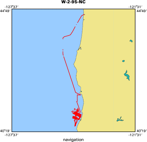
Location map
|

|
|
Bounding Coordinates
|
44.62695
-125.08788 -124.04286
40.52999
|
|
Dates
|
09/01/1995 (JD 244) to 09/15/1995 (JD 258)
|
|
Analog Materials
|
list
|
|
Index map

|
|
|
Crew
|
|
Mike Field
|
Chief Scientist, USGS Western Region
|
|
Jim Gardner
|
Co-chief Scientist, USGS Western Region
|
|
Mike Boyle
|
Electrical Technician, USGS Western Region
|
|
Larry Kooker
|
Electrical Technician, USGS Western Region
|
|
John Gann
|
Electrical Technician, USGS Western Region
|
|
Kevin O'Toole
|
Mechanical Technician, USGS Western Region
|
|
Pete Galanis
|
Watchstander, USGS Western Region
|
|
Stuart Sides
|
Watchstander, USGS Western Region
|
|
Jeff Anderson
|
Watchstander
|
|
Dan Orange
|
Watchstander
|
|
|
Equipment Used
|
|
Huntec
|
|
sidescansonar
|
|
mudseis
|
|
SIS1000
|
|
YoNav
|
|
|
Summary
|
|
We gathered Huntec digital high-resolution and
|
|
Datasonics SIS-1000 sidescan
|
|
over an inner shelf region, a shelf-to-slope region, and over the Humboldt Slide.
|
|
We collected great views of the midshelf mud belt
|
|
as well as the clinoforms that drape the outer shelf and upper slope.
|
|
These data will provide the geometrical input into a numerical model
|
|
of siliclastic sedimentation, one of the primary objectives of STRATAFORM.
|
|
|
Notes
|
|
|
Publications
|
|
Mayer, Larry, Fonseca, Luciano, Pacheco, Miguel, Galway, Sean, Vicente Martinez,
|
|
Jose, Hou, Tianhang, Orange, Dan, Gulick, Sean, Yun, Janet, Gardner, James V.,
|
|
Dartnell, Pete, Lee, Homa, and Cutter, Randy, 200?, The STRATAFORM GIS:
|
|
University of New Brunswick, Office of Naval Research.
|
|
|
Got Help?
|
For W-2-95-NC, we would appreciate any information on -- contract, days at sea, dive count, funding, information specialist, information to be derived, kms of navigation, national plan, NGDC Info, owner, ports, project number, purpose, scanned materials, seismic description, station count, station description, submersible, tabulated info.
|
|


