|
|
|
Metadata
|
|
ID
|
R-3-00-GC
|
|
Abstract
|
United States Geological Survey, Menlo Park, California.
Chief Scientist: Roberto Anima. Geophysical data
(Kleinsidescan, mudseis, GPS, GPS) of field activity
R-3-00-GC in Colorado River/Grand Canyon from 08/28/2000 to
09/05/2000
|
|
Organization
|
United States Geological Survey, Menlo Park, California
|
|
Project/Theme
|
Colorado River Sand Distribution Monitoring
|
|
Chief Scientist
|
Roberto Anima
|
|
Activity Type
|
Geophysical
|
|
Area of Operation
|
Colorado River/Grand Canyon
|
|
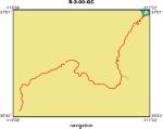
Location map
|
|
|
Bounding Coordinates
|
36.94507
-113.37013 -111.46322
35.76981
|
|
Ports
|
leave Glen Canyon Dam
arrive Diamond Creek
|
|
Dates
|
08/28/2000 (JD 241) to 09/05/2000 (JD 249)
|
|
Analog Materials
|
list
|
|
Index map

|
|
|
Information Specialist
|
|
|
Crew
|
|
Roberto Anima
|
Chief Scientist, USGS Western Region
|
|
Dave Hogg
|
Electronics Technician, USGS Western Region
|
|
Mike Hamer
|
Gis/navigator, USGS Western Region
|
|
Fred Payne
|
Electronics Technician, USGS Western Region
|
|
Joseph Rios
|
Pst, USGS Western Region
|
|
Kelly Mahoney
|
Geologist, Volunteer
|
|
Lars Neimi
|
Head Boatman,
|
|
Dennis Harris
|
Boatman,
|
|
Cindy Di Francisco
|
Cook,
|
|
|
Equipment Used
|
|
Kleinsidescan
|
|
mudseis
|
|
GPS
|
|
GPS
|
|
|
Purpose
|
|
Survey time variable sand distributions along the Colorado River
|
|
|
Information to be Derived
|
|
The distribution of sand size along the Colorado River
|
|
|
Summary
|
|
Completed side-scan survey of Colorado River/Grand Canyon from Glen Canyon Dam to Diamond Creek
|
|
|
Notes
|
|
|
Got Help?
|
For R-3-00-GC, we would appreciate any information on -- contract, days at sea, dive count, funding, kms of navigation, national plan, NGDC Info, owner, platform, project number, publications, scanned materials, seismic description, station count, station description, submersible, tabulated info.
|
|


