|
|
|
|
Metadata
|
|
ID
|
01RCE03
|
|
Also Known As
|
G-3-01-LA
|
|
Abstract
|
United States Geological Survey, St. Petersburg,
Florida,Lake Pontchartrain Basin Foundation,Eckerd College.
Chief Scientist: Jim Flocks. Geological data (vibratingcore)
of field activity 01RCE03 (G-3-01-LA) in Lake Pontchartrain
Inner Harbor Navigation Canal & Mississippi River from
05/19/2001 to 05/25/2001
|
|
Organization
|
United States Geological Survey, St. Petersburg, Florida
Lake Pontchartrain Basin Foundation
Eckerd College
|
|
Project/Theme
|
Sediment-hosted contaminants in the Lower Atchafalaya and Mississippi Rivers
|
|
Chief Scientist
|
Jim Flocks
|
|
Activity Type
|
Geological
|
|
Platform
|
Gilbert
|
|
Area of Operation
|
Lake Pontchartrain Inner Harbor Navigation Canal & Mississippi River
|
|
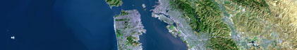
Location map
|

|
|
Bounding Coordinates
|
29.18344
-89.21670 -89.06668
29.06676
|
|
Ports
|
leave Cocodrie, Louisiana
arrive Cocodrie, Louisiana
|
|
Dates
|
05/19/2001 (JD 139) to 05/25/2001 (JD 145)
|
|
Analog Materials
|
No analog holdings.
|
|
Index map

|
|
|
Information Specialist
|
|
|
Crew
|
|
Jim Flocks
|
Chief Scientist, USGS St. Petersburg
|
|
Kate Ciembronowicz
|
Geologist/ Facs Curator, USGS St. Petersburg
|
|
Dave Bennett
|
Boat Captain , Eckard College
|
|
Greg Berman
|
Crew Hand, USGS St. Petersburg
|
|
Neil Armingeon
|
Observer (5/21/01 Only), Lake Pontchartrain Basin Foundation
|
|
|
Equipment Used
|
|
|
Purpose
|
|
To evaluate the storage and transport of particle reactive, environmentally relevant contaminates through the Mississippi River and Atchafalaya River delta complexes to the near-shore Gulf of Mexico.
|
|
|
Information to be Derived
|
|
Sediment cores will be used to evaluate the distribution and concentrations of key contaminates.
|
|
|
Summary
|
|
Collected 7 vibracores along the Mississippi River and Delta.
|
|
|
Got Help?
|
For 01RCE03, we would appreciate any information on -- analog materials, contract, days at sea, dive count, funding, kms of navigation, national plan, NGDC Info, notes, owner, project number, publications, scanned materials, seismic description, station count, station description, submersible, tabulated info.
|
|