|
|
|
Metadata
|
|
ID
|
F-6-89-GA
|
|
Abstract
|
Chief Scientists: Paul Carlson, Dennis Mann, Quentin
Hugget. Geophysical data (3dot5khz, 10khz, 2channelairgun,
gravity, magnetics, Gloriasidescan, expendablebatthermograph,
GPS, integratednavigation, RhoRho) of field activity
F-6-89-GA in Gulf of Alaska from 05/16/1989 to 06/12/1989
|
|
Project/Theme
|
Geological Long-Range Inclined Asdic (GLORIA)
|
|
Chief Scientist
|
Paul Carlson
Dennis Mann
Quentin Hugget
|
|
Activity Type
|
Geophysical
|
|
Platform
|
Farnella
|
|
Area of Operation
|
Gulf of Alaska
|
|
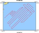
Location map
|
|
|
Bounding Coordinates
|
59.32273
-151.70876 -140.82391
54.27983
|
|
Ports
|
leave Kodiak, AK
arrive Sitkalidik Strait
leave Sitkalidik Strait
arrive Kodiak, AK-Repair G
leave Kodiak, AK
arrive Yakutat, AK
|
|
Dates
|
05/16/1989 (JD 136) to 06/12/1989 (JD 163)
|
|
Analog Materials
|
list
|
|
Index map

|
|
|
Crew
|
|
Paul Carlson
|
Chief Scientist, USGS Western Region
|
|
Dennis Mann
|
Chief Scientist, USGS Western Region
|
|
Quentin Hugget
|
Chief Scientist, IOS
|
|
Larry Kooker
|
Electronic Tech, USGS Western Region
|
|
Kaye Kinoshita
|
Navigator, USGS Western Region
|
|
Mike Hamer
|
Geologist, USGS Western Region
|
|
Rick Morgan
|
Watchstander, USGS Western Region
|
|
Derek Bishop
|
Gloria Chief, IOS
|
|
Alan Gray
|
Mech Engineer, IOS
|
|
Andy Harris
|
Gloria Watchstander, IOS
|
|
Adrian Fern
|
Computer, IOS
|
|
John Cannon
|
Captain, J. Marr
|
|
Mike Baldwin
|
Chief Engineer, J. Marr
|
|
Lee Hussey
|
1st Engineer, J. Marr
|
|
Arthur Green
|
2nd Engineer, J. Marr
|
|
Bill Wilson
|
1st Mate, J. Marr
|
|
Albert Fuller
|
2nd Mate, J. Marr
|
|
Alan Thompson
|
Bosum, J. Marr
|
|
Peter Appleyard
|
Ab, J. Marr
|
|
Colin Bettison
|
Ab, J. Marr
|
|
Kenny Coleman
|
Ab, J. Marr
|
|
Robin Searle
|
Electrician, J. Marr
|
|
Gordon McFadden
|
Cook, J. Marr
|
|
Tom Caughie
|
2nd Cook, J. Marr
|
|
Tony Zielinski
|
Steward, J. Marr
|
|
|
Equipment Used
|
|
3dot5khz
|
|
10khz
|
|
2channelairgun
|
|
gravity
|
|
magnetics
|
|
Gloriasidescan
|
|
expendablebatthermograph
|
|
GPS
|
|
integratednavigation
|
|
RhoRho
|
|
|
Notes
|
|
|
NGDC Overview
|
|
! Converted to time format with year at start.
|
|
!
|
|
DATA COLLECTION OVERVIEW (use NGDC GEODAS CD to retrieve data)
|
|
|
|
MCG Data Collection ID --- F689GA
|
|
Institution Data Collection ID --- FARN0689
|
|
NGDC ID --- 06780054
|
|
Funding --- USGS
|
|
Project, Cruise & Leg --- MV FARNELLA CRUISE 6, 1989.
|
|
Study region --- +60.00000,+54.00000,-153.00000,-140.00000
|
|
Chief Scientist(s) --- DR Q.J. HUGGETT, IOSDL
|
|
Name of vessel --- MV FARNELLA (surface ship)
|
|
Date field data collection started --- 05/25/89 KODIAK, USA
|
|
Date field data collection ended --- 06/12/89 YAKUTAT, USA
|
|
Parameters surveyed ---
|
|
Bathymetry: surveyed, contained in data file
|
|
Magnetics: surveyed, contained in data file
|
|
Gravity: surveyed, contained in data file
|
|
High-resolution seismics: (unspecified)
|
|
Deep penetration seismics: (unspecified)
|
|
Format --- (I1,A8,F5.2,4I2,F5.3,F8.5,F9.5,I1,F6.4,F6.1,I2,i1,3F6.1,I1,F5.1,F6.0,F7.1,F6.1,F5.1,A8,4I1)
|
|
Date of data input to NGDC --- 04/25/94
|
|
Contributing institution --- NATURAL ENVIRONMENT RESEARCH COUNCIL
|
|
Country --- UNITED KINGDOM
|
|
|
|
Navigation instrumentation --- GPS
|
|
Position determination method --- SATELLITE
|
|
|
|
Bathymetry instrumentation --- IOS MK3 10KHZ ECHO-SOUNDER
|
|
Additional forms of bathymetric data --- ANALOG RECORDS
|
|
General rate of bathymetry in file --- 2.0 minutes
|
|
General collection rate of bathymetry --- (unspecified)
|
|
Assumed sound velocity --- (unspecified)
|
|
Bathymetric datum code --- No correction applied (sea level)
|
|
Bathmetry interpolation scheme --- (unspecified)
|
|
|
|
Magnetics instrumentation --- (unspecified)
|
|
Additional forms of magnetics data --- (unspecified)
|
|
General rate of magnetics in file --- 2.1 minutes
|
|
General collection rate of magnetics --- (unspecified)
|
|
Magnetic sensor tow distance --- (unspecified)
|
|
Magnetic sensor depth --- (unspecified)
|
|
Two sensor horizontal separation --- (unspecified)
|
|
Residual magnetics reference field --- (unspecified)
|
|
Method of applying residual field --- (unspecified)
|
|
|
|
Gravity instrumentation --- (unspecified)
|
|
Additional forms of gravity data --- (unspecified)
|
|
General rate of gravity in file --- 2.0 minutes
|
|
General collection rate of gravity --- (unspecified)
|
|
Theoretical gravity formula --- (unspecified)
|
|
Reference system --- (unspecified)
|
|
Corrections applied --- (unspecified)
|
|
Starting land tie --- (unspecified)
|
|
Ending land tie --- (unspecified)
|
|
|
|
Seismic instrumentation --- (unspecified)
|
|
Formats of seismic data --- (unspecified)
|
|
|
Publications
|
|
Bruns, T.R., Carlson, Paul R., Stevenson, A.J., Fisher, M.A., Ryan, H.F., Mann, D.M.,
|
|
Dobson, Maxwell, Huggett, Quentin J., Parson, Lindsay M., and Fannin, N.G.T., 1990,
|
|
GLORIA images from the Gulf of Alaska and British Columbia; subduction zones, transforms,
|
|
and channels, in Carter, L.M.H., ed., USGS research on energy resources, 1990;
|
program and abstracts: U.S. Geological Survey Circular 1060, p. 11-12.
|
|
|
Carlson, Paul R., Mann, Dennis M., Huggett, Quentin J., and Bishop, Derek, 1990, GLORIA investigation
|
|
of the Exclusive Economic Zone in the Gulf of Alaska; M/V Farnella Cruise F6-89-GA, May 16 to June
|
11, 1989: U.S. Geological Survey Open-File Report 90-0071, 17 p.
|
|
|
Carlson, Paul R., Bruns, Terry R., Huggett, Quentin J., Mann, Dennis M., and
|
|
Stevenson, Andrew J., 1990, GLORIA imagery links sedimentation in Aleutian Trench to
|
|
Yakutat margin via Surveyor Channel: American Association of Petroleum Geologists Bulletin,
|
v. 74, no. 6, p. 962-963.
|
|
|
Stevenson, Andrew J., Bruns, Terry R., Carlson, Paul R., and Dobson, Maxwell R.,
|
|
1990, Sediment transport and fan deposition in the Gulf of Alaska; effects of transform
|
|
motion on deep sea sedimentation: American Association of Petroleum Geologists Bulletin,
|
v. 74, no. 6, p. 1003.
|
|
|
Bruns, Terry R., Carlson, Paul R., Stevenson, A.J., Fisher, Michael A., Ryan, H.F.,
|
|
Mann, D.M., Dobson, Maxwell R., Huggett, Quentin J., Parson, Lindsay M.,
|
|
and Fannin, N.G.T., GLORIA mosaic of the Gulf of Alaska and the British Columbia margin;
|
|
deep-sea channels, margin deformation, and the Queen Charlotte Fault: American Association
|
of Petroleum Geologists Bulletin, v. 74, no. 5, p. 620.
|
|
|
Carlson, Paul R., Bruns, T.R., Stevenson, A.J., Mann, D.M., Huggett, Quentin J.,
|
|
Wormly, U.K., and Dobson, Maxwell R., 1990, Sedimentary depositional environments in
|
|
the Gulf of Alaska from GLORIA imagery: American Association of Petroleum Geologists
|
Bulletin, v. 74, no. 5, p. 624.
|
|
|
Carlson, P.R., Bruns, T.R., Mann, D.M., and Stevenson, A.J., 1996, Gloria
|
|
imagery links sedimentaiton in Aleutian Trench and Abyssal Plain to Yakutat
|
|
Margin via deep-sea channels: Houston, TX, Gulf Publishing Co., Fifth
|
|
Circum-Pacific Energy and Mineral Resources Conference Transactions,
|
p. 695-702.
|
|
|
Got Help?
|
For F-6-89-GA, we would appreciate any information on -- contract, days at sea, dive count, funding, information specialist, information to be derived, kms of navigation, national plan, organization, owner, project number, purpose, scanned materials, seismic description, station count, station description, submersible, summary, tabulated info.
|
|